
Newtongrange, Lady Victoria Colliery


Colliery (19th Century), Museum (20th Century)
Site Name Newtongrange, Lady Victoria Colliery
Classification Colliery (19th Century), Museum (20th Century)
Alternative Name(s) Scottish Mining Museum; Lady Victoria Colliery; Lothian Coal Company Limited
Canmore ID 53619
Site Number NT36SW 22
NGR NT 33262 63693
NGR Description Centred NT3335 6355 and NT3323 6397 to NT3338 6320
Datum OSGB36 - NGR
Permalink http://canmore.org.uk/site/53619


First 100 images shown. See the Collections panel (below) for a link to all digital images.
- Council Midlothian
- Parish Cockpen
- Former Region Lothian
- Former District Midlothian
- Former County Midlothian
Dating from the 19th century, Lady Victoria Colliery ceased production in 1981 and is now the home of the Scottish Mining Museum. The colliery was named in honour of the wife of the Marquis of Lothian, who also built the neighbouring village of Newtongrange to house the miners from the pit. Originally, the shaft was sunk to a depth of 530m and, for a while, it was the deepest pit in Scotland. Later in its working life, the colliery also served as an engineering centre for the area.
Information from RCAHMS (MKO, SC) 20 June 2007
Oglethorpe, M K 2006
NT36SW 22.00 centred 3335 6355 and 3323 6397 to 3338 6320
NT36SW 22.01 centred 3344 6371 Lothian Coal Company Offices (Former SMM Visitor Centre)
NT36SW 22.02 centred 3340 6375 Gantry
NT36SW 22.03 centred 3336 6376 Time Office and Lamp Station (Former Cement Store)
NT36SW 22.04 centred 3336 6379 British Coal Archive (Former Colliery Workshop)
NT36SW 22.05 centred 3333 6376 New Visitor Centre (New Power Station and Old Power Station)
NT36SW 22.06 centred 3332 6380 Boiler House and Chimney (Original Boiler House)
NT36SW 22.07 centred 3329 6377 Dredger
NT36SW 22.08 centred 3327 6381 Fines Treatment Plant and Thickener
NT36SW 22.09 centred 3327 6377 Engine Houses Pithead Woodroad Stores
NT36SW 22.10 centred 3331 6374 Winding Engine House
NT36SW 22.11 centred 3327 6374 Headgear
NT36SW 22.12 centred 3327 6373 Mine Shaft and Railway Tunnel
NT36SW 22.13 centred 3326 6371 Pithead Building (Tub Circuit, Tippler Section, Picking Tables)
NT36SW 22.14 centred 3335 6367 South Elevator Conveyor System
NT36SW 22.15 centred 3328 6368 Dense Medium Plant
NT36SW 22.16 centred 3329 6368 Coal Elevator Shed and Hopper
NT36SW 22.17 centred 3330 6369 Old Washer Plant
NT36SW 22.18 centred 3330 6373 Smithy
NT36SW 22.19 centred 3340 6360 Central Workshops
The above subsectioning was adopted from the annotated birdseye view of the Scottish Mining Museum at Lady Victoria Colliery, Newtongrange, collection number E94228 PO.
For associated and adjacent mining village (miners' rows) of Newtongrange, see NT36SW 63 and buildings referenced individually therein.
Not to be confused with Scottish Mining Museum, Prestongrange (NT 373 736), for which see NT37SE 78.00.
Scottish Mining Museum
Lady Victoria Colliery [NAT]
OS (GIS) AIB, April 2006.
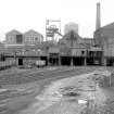
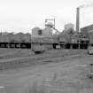
(Location cited as NT 333 636). Lady Victoria Colliery, Newtongrange. Sunk 1890-4 by the Lothian Coal Co Ltd. The surface buildings here are extensive, and are steel-framed with brick cladding or infilling. There is a very fine steam winding-engine built by Grant, Ritchie and Co Ltd, Kilmarnock in 1894, with 3ft 6ins (1.06m) by 7ft (2.13m) cylinders and Cornish drop valves. This is supplied with steam by a bank of seven Lancashire boilers. There is a tall circular-section brick chimney.
J R Hume 1976.
The Midlothian Coal Basin is shaped like a trough running approximately north-east to south-west. The Lady Victoria Colliery shaft was sunk to reach the deeper coals that its predecessors (Lingerwood, Bryans, Easthouses) could not work efficiently. The shaft itself sits between the outcrop and the floor of the basin.
The workings extended three miles (4.5km) to the east, almost to the village of Rosewell and almost two miles (3km) northwards to Eskbank. Lady Victoria Colliery was linked underground to the neighbouring Lingerwood Colliery.
An unusual characteristic of Lady Victoria Colliery is that it has only one headgear and one shaft.
Lady Victoria Colliery was connected to the Waverley Line (opened 1849), and was constructed with extensive railway marshalling yards and sidings. The colliery stopped shipping coal by rail in 1968, and the Waverley Line was closed in 1969.
Prior to the introduction of the Pithead Baths, in 1954, the miners came home dirty to a tub in front of the fire.
The miners would both start and finish their working day at the baths. Each miner had a clean and a dirty locker, which were situated on opposite sides of the showers. The pithead baths were demolished in 1986.
The 'Lady Vic Canteen' had quite a reputation locally as a good place to eat. This was probably a reflection of its good value plain home cooking (on an enormous scale) and subsidised prices. The canteen was contemporary with the baths
Information taken from Lady Victoria Scottish Mining Museum pamphlet dated 1991.
NMRS REFERENCE:
NMRS Library Cuttings
The Scotsman 8/2/92
'£5m project begins at Mining Museum - article.
(Undated) information in NMRS.
In March 1998 a detailed photographic survey of Lady Victoria Colliery was carried out by RCAHMS in partnership with the Scottish Mining Museum Trust, prior to a #3 million Lottery-funded development. This development project was completed in September 1999 and was referred to as the Phase 3 Development. It involved the development and conservation of parts of the pit-head building. The photographic survey itself focussed on the pithead area along with some more general views.
Visited by RCAHMS (MKO), January and March 1998.
(Location cited as NT 3327 6375). LADY VICTORIA Colliery (also known as THE LADY)
Location: Newtongrange
Previous Owners: Lothian Coal Company
Types of Coal: Gas, House and Steam
Sinking/Production Commenced: 1895
Year Closed: 1981
Year Abandoned: 1982
Average Workforce: 1,339
Peak Workforce: 1,765
Peak Year: 1953
Shaft/Mine Details: 1 shaft, 487m in 1948. When originally sunk, it was walled simultaneously, rendering it watertight. Originally 530m deep, it was the deepest in Scotland at the time, and was connected to neighbouring Lingerwood (NT36SW 43), preventing the need for a second shaft.
Details in 1948: Output 1,388 tons per day, 347,000 per annum. 1,080 employees. Campbell Binnie bash type washer, rewasher Baum-type, locally made. Canteen, first-aid room, ambulance. Electricity generated in own power stations, some sent to Easthouses Colliery (NT36NW 164). Report dated 15-08-1948.
Other Details: Named in honour of the wife of the Marquis of Lothian. Neighbouring Newtongrange village was built by the Marquis of Lothian to house miners to work the pit. Became showpiece pit of the Lothian Coal Company, with the largest-diameter shaft in Scotland at the time, served by a large Grant Ritchie of Kilmarnock steam winding engine. A bad fire in the winding engine house led to refurbishment in 1903. The steam winder was later powered by a boilerhouse re-equipped with 12 war-surplus Lancashire boilers dating from c.1920. Prior to the mechanisation of underground haulage, 120 ponies were employed underground. In the National Coal Board (NCB) era, the colliery also became a major engineering workshop centre for the Lothians area. Baths serving both Lady Victoria and Lingerwood (NT36SW 43) were opened in 1954, and a reinforced concrete heated walkway over the A7 trunk road connected them to the pithead. Following closure in 1981, much of the surface arrangement was rescued from demolition, and with the assistance of Lothian Region, was transformed into the Scottish Mining Museum, operating initially as a dual site with Prestongrange in neighbouring East Lothian.
M K Oglethorpe 2006.
Construction (1893)
Photographic Record (21 April 1960 - 24 December 1964)
Reference (1976)
(Location cited as NT 333 636). Lady Victoria Colliery, Newtongrange. Sunk 1890-4 by the Lothian Coal Co Ltd. The surface buildings here are extensive, and are steel-framed with brick cladding or infilling. There is a very fine steam winding-engine built by Grant, Ritchie and Co Ltd, Kilmarnock in 1894, with 3ft 6ins (1.06m) by 7ft (2.13m) cylinders and Cornish drop valves. This is supplied with steam by a bank of seven Lancashire boilers. There is a tall circular-section brick chimney.
J R Hume 1976
Publication Account (1985)
The Lothian Coal Company began to sink the Lady Victoria shaft in 1890. Originally planned to reach 531 m, uncontrollable flooding caused it to be backfilled to 503 m. The original block of buildings still survives - brick-built furnace house, winding-engine house and ancillary buildings. Seven of the second set of 12 'Lancashire' boilers remain in position, producing steam until 1982 to help power underground machinery as well as the pit-head baths and the winding-engine.
High above the colliery stand the twin symbols of a late 19th-mid 20th century colliery - the brick-built chimney and the pit-head gantry supporting the pulley wheels over which the winding-ropes passed down to the cages. The winding-engine house was the heart of the colliery. Like the original rope-drum, the present winding-engine was built by Grant Ritchie & Co Ltd,
of Kilmarnock in 1894. A massive piece of machinery, it hissed and clanked, pistons gradually turning as it began to let out or haul in the thick wire ropes. It survived as a dinosaur into the age of microelectronics, and has now become extinct, though preserved.
The Lothian Coal Company had been headed by the Marquis of Lothian, descendant of the last abbot of Newbattle, Mark Ker, who secularised his mining interests after the Reformation. To house the miners for his new pit, called after his wife, the Marquis established a company village. Built of brick from the local brickworks, Newtongrange was to become the largest pit village in Scotland. The terraced houses were laid out in a grid pattern and named accordingly - First Street, Second Street .. ; each had its flower garden in front and vegetable garden behind, with outdoor dry closet. The Company also built miners' institutions with reading rooms and libraries, football pitches and bowling greens.
Nearby Rosewell (NT 288627) is one of the most complete pit villages to survive, built even more distinctively in yellow as well as red brick. Its Roman Catholic Church, St Matthew's (1926) is built of the same yellow, industrial brick.
Information from 'Exploring Scotland's Heritage, Lothian and Borders',(1985)
Photographic Survey (1 March 1998 - 31 March 1998)
In March 1998 a detailed photographic survey of Lady Victoria Colliery was carried out by RCAHMS in partnership with the Scottish Mining Museum Trust, prior to a 3 million pound Lottery-funded development. This development project was completed in September 1999 and was referred to as the Phase 3 Development. It involved the development and conservation of parts of the pit-head building. The photographic survey itself focussed on the pithead area along with some more general views.
Photographic Survey (7 September 1999)
Project (2007)
This project was undertaken to input site information listed in 'Civil engineering heritage: Scotland - Lowlands and Borders' by R Paxton and J Shipway, 2007.
Publication Account (2007)
Lady Victoria Colliery is considered the most complete example of a late-19th century model in Europe. It is the only coherent coal-mining complex to have survived in Scotland following the cessation of deep mining in 2002, and is all the more important because of its situation on the edge of Scotland’s finest mining village, Newtongrange.
At the time of its sinking by the Lothian Coal Company in the early 1890s, its shaft was thought to be the largest diameter and deepest in the country, and was designed to extract 1200 tons of coal per day. This was achieved by a 2400 hp steam winding engine built by Grant Ritchie of Kilmarnock, in combination with a substantial steel headframe constructed by Sir William Arrol & Co. of Glasgow in 1893. At ground level, the pithead buildings comprise a central block of mostly red-brick arcades through which sidings from the adjacent Waverley line passed, allowing coal to be rapidly dispatched to markets in Edinburgh, and to mill towns in the Borders. The upper levels contain the mine-car circuit, coal-picking tables, and a coal preparation plant. Following the closure of the colliery in 1981 the site was conserved as the Scottish Mining Museum thus retaining its most important elements for posterity and providing a major public visitor attraction. An unusual surviving ‘bridge’ element is the reinforced concrete walkway over the A7 trunk road. This facility connected the pithead with the baths and canteen on the opposite side of the road. It was designed by National Coal Board Scottish Region’s Austrian architect, Egon Riss, who was also responsible for designing the new generation of superpits in Scotland (such as Rothes in Fife, Killoch in Ayrshire, and Bilston Glen nearby in Midlothian), as well as the prestigious reconstructions at Kinneil (Bo’ness) and Barony (Auchinleck).
R Paxton and J Shipway 2007
Reproduced from 'Civil Engineering heritage: Scotland - Lowlands and Borders' with kind permission of Thomas Telford Publishers.
Field Visit (April 2009 - February 2015)
The Borders Railway Project proposals are to reinstate the Newcraighall to Tweedbank section of the former Waverley Line. The reinstated railway line will be approximately 48km long and the majority of the route will use the existing railway embankment.
Several field surveys, archaeological evaluations and standing building surveys were undertaken by CFA Archaeology from April 2009 until February 2015.
CFA Archaeology

