
Chalkieside


Enclosed Settlement (Prehistoric)
Site Name Chalkieside
Classification Enclosed Settlement (Prehistoric)
Canmore ID 53402
Site Number NT36NE 8
NGR NT 36677 68120
Datum OSGB36 - NGR
Permalink http://canmore.org.uk/site/53402


- Council East Lothian
- Parish Inveresk (East Lothian)
- Former Region Lothian
- Former District East Lothian
- Former County Midlothian
NT36NE 8 NT 36677 68120
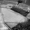
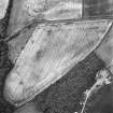
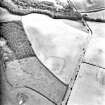
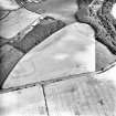
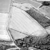
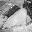
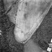
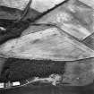
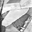
NT 3667 6812. Situated on the slightly sloping S face of a cultivated field, approximately 70m of the E side and 80m of the S side of a rectangular crop mark can be seen on air photographs. Further unintelligible marks can be seen at the N end of the E side. There is nothing to be seen on the ground and no surface finds have been made. Site surveyed at 1:2500 from APs.
Visited by OS (RD) 1 March 1971
This probably rectangular ditched enclosure is one of at least twenty enclosures in Mid- and East Lothian which are superficially comparable with timber-house sites of the Northumberland coastal plain, dating from the Iron Age.
G Maxwell 1970
Information to follow.
RCAHMS (KB) 1 March 2000
NT3667 6812 Site identified during an archaeological assessment carried out by CFA Archaeology Ltd.
Mhairi Hastie, 2006.
Field Visit (1 March 1971)
NT 3667 6812. Situated on the slightly sloping S face of a cultivated field, approximately 70m of the E side and 80m of the S side of a rectangular crop mark can be seen on air photographs. Further unintelligible marks can be seen at the N end of the E side. There is nothing to be seen on the ground and no surface finds have been made. Site surveyed at 1:2500 from APs.
Visited by OS (RD) 1 March 1971
Aerial Photographic Transcription (1990)
An aerial transcription was produced from oblique aerial photographs. Information from Historic Environment Scotland (BM) 31 March 2017.
Desk Based Assessment (2006)
NT3667 6812 Site identified during an archaeological assessment carried out by CFA Archaeology Ltd.
Mhairi Hastie, 2006.
Aerial Photographic Transcription (15 March 2019)
An interpretative transcription, or mapping, of information on oblique aerial photographs was produced on 15 March 2019.

