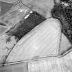
 |
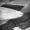
On-line Digital Images |
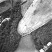
SC 1736284 |
RCAHMS Aerial Photography |
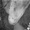
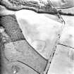
Oblique aerial view centred on the cropmarks of the settlements and quarry, taken from the SSW. |
22/7/2003 |
Item Level |
|
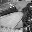 |
On-line Digital Images |
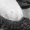
SC 1736286 |
RCAHMS Aerial Photography |
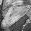
Oblique aerial view centred on the cropmarks of the settlement with the cropmarks of the quarry adjacent, taken from the SSE. |
22/7/2003 |
Item Level |
|
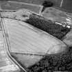 |
On-line Digital Images |
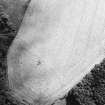
SC 1736287 |
RCAHMS Aerial Photography |
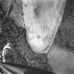
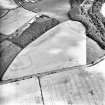
Oblique aerial view centred on the cropmarks of the settlements and quarry, taken from the ESE. |
22/7/2003 |
Item Level |
|
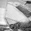 |
On-line Digital Images |
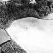
SC 1736288 |
RCAHMS Aerial Photography |
Oblique aerial view centred on the cropmarks of the settlements and quarry, taken from the E. |
22/7/2003 |
Item Level |
|
 |
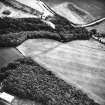
On-line Digital Images |
SC 1736404 |
RCAHMS Aerial Photography |
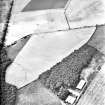
Chalkieside, enclosures: oblique air photograph. |
1994 |
Item Level |
|
 |
On-line Digital Images |
SC 1736405 |
RCAHMS Aerial Photography |
Chalkieside, enclosures: oblique air photograph. |
1994 |
Item Level |
|
 |
On-line Digital Images |
SC 1736406 |
RCAHMS Aerial Photography |
Chalkieside, enclosures: oblique air photograph. |
1994 |
Item Level |
|
 |
On-line Digital Images |
SC 1736413 |
RCAHMS Aerial Photography |
Oblique aerial photograph |
1994 |
Item Level |
|
 |
On-line Digital Images |
SC 1736414 |
RCAHMS Aerial Photography |
Oblique aerial photograph |
1994 |
Item Level |
|
 |
On-line Digital Images |
SC 1736448 |
RCAHMS Aerial Photography |
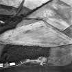
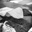
Chalkieside and Salters' Road, oblique aerial view, taken from the E, centred on the cropmarks of an enclosure and a possible road. |
13/8/1996 |
Item Level |
|
 |
On-line Digital Images |
SC 1736449 |
RCAHMS Aerial Photography |
Chalkieside and Salters' Road, oblique aerial view, taken from the NNE, centred on the cropmarks of an enclosure and a possible road. |
13/8/1996 |
Item Level |
|
 |
On-line Digital Images |
SC 1736450 |
RCAHMS Aerial Photography |
Chalkieside and Salters' Road, oblique aerial view, taken from the WNW, centred on the cropmarks of an enclosure and a possible road. |
13/8/1996 |
Item Level |
|
 |
On-line Digital Images |
SC 1736497 |
RCAHMS Aerial Photography |
Oblique aerial photograph |
1981 |
Item Level |
|
 |
On-line Digital Images |
SC 1736498 |
RCAHMS Aerial Photography |
Oblique aerial photograph |
1981 |
Item Level |
|
 |
On-line Digital Images |
SC 1736500 |
RCAHMS Aerial Photography |
Oblique aerial photograph |
1981 |
Item Level |
|
 |
On-line Digital Images |
SC 1784779 |
RCAHMS Aerial Photography |
Oblique aerial view. |
1988 |
Item Level |
|
 |
On-line Digital Images |
SC 1784780 |
RCAHMS Aerial Photography |
Oblique aerial view. |
1988 |
Item Level |
|
 |
On-line Digital Images |
SC 1784781 |
RCAHMS Aerial Photography |
Oblique aerial view. |
1988 |
Item Level |
|
 |
On-line Digital Images |
SC 1784782 |
RCAHMS Aerial Photography |
Oblique aerial view. |
1988 |
Item Level |
|
|
On-line Digital Images |
AT 003465 |
Historic Environment Scotland |
Imagery and Mapping Files for Aerial Photo Transcription |
15/3/2019 |
Item Level |
|
 |
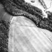
On-line Digital Images |
SC 2445314 |
Records of the Ordnance Survey, Southampton, Hampshire, England |
Chalkieside, NT36NE 50, Ordnance Survey index card, Recto |
1958 |
Item Level |
|


