
Chalkieside


Settlement (Prehistoric)
Site Name Chalkieside
Classification Settlement (Prehistoric)
Alternative Name(s) Chalkieside Quarry
Canmore ID 53374
Site Number NT36NE 50
NGR NT 36931 68249
Datum OSGB36 - NGR
Permalink http://canmore.org.uk/site/53374


- Council East Lothian
- Parish Inveresk (East Lothian)
- Former Region Lothian
- Former District East Lothian
- Former County Midlothian
NT36NE 50 NT 36931 68249
Scheduled as Chalkieside Quarry, enclosure.
Information from Historic Scotland, scheduling document dated 28 July 1995.
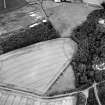
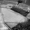
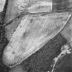
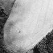
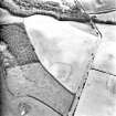
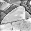
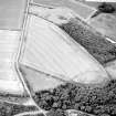
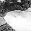
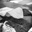
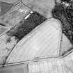
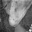
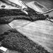
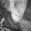
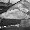
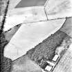
Oblique aerial photography has revealed the cropmarks of an enclosure 300m SSE of Chalkieside farmhouse (NT36NE 39). It comprises a possible sub-rectangular enclosure defined by an arc of ditch on the W and SW sides and it measures at least 90m across with a possible entrance in the SW side. The cropmarks of four enclosures have been recorded in the surrounding area (NT36NE 7, NT36NE 8, NT36NE 15, NT36NE 51 ) and the cropmarks of the possible 'Salters' Road' passes immediately to the SW of the enclosure (NT36NE 72).
Information from RCAHMS (KJ) 23 February 2000.
Site identified during an archaeological assessment carried out by CFA Archaeology Ltd.
Mhairi Hastie, 2006.
Aerial Photography (27 July 1979)
Aerial Photography (1988)
Aerial Photographic Transcription (1990)
An aerial transcription was produced from oblique aerial photographs. Information from Historic Environment Scotland (BM) 31 March 2017.
Aerial Photographic Interpretation (23 February 2000)
Oblique aerial photography has revealed the cropmarks of an enclosure 300m SSE of Chalkieside farmhouse (NT36NE 39). It comprises a possible sub-rectangular enclosure defined by an arc of ditch on the W and SW sides and it measures at least 90m across with a possible entrance in the SW side. The cropmarks of four enclosures have been recorded in the surrounding area (NT36NE 7, 8, 15 and 51) and the cropmarks of the possible 'Salters' Road' passes immediately to the SW of the enclosure (NT36NE 72).
Information from RCAHMS (KJ) 23 February 2000.
Desk Based Assessment (2006)
Site identified during an archaeological assessment carried out by CFA Archaeology Ltd.
Mhairi Hastie, 2006.
Aerial Photographic Transcription (15 March 2019)
An interpretative transcription, or mapping, of information on oblique aerial photographs was produced on 15 March 2019.

