
Plora Burn


Farmstead (Period Unassigned), Garden (Period Unassigned)(Possible), Tower House (Medieval)
Site Name Plora Burn
Classification Farmstead (Period Unassigned), Garden (Period Unassigned)(Possible), Tower House (Medieval)
Canmore ID 53101
Site Number NT33NE 11
NGR NT 3609 3629
Datum OSGB36 - NGR
Permalink http://canmore.org.uk/site/53101


- Council Scottish Borders, The
- Parish Traquair
- Former Region Borders
- Former District Tweeddale
- Former County Peebles-shire
NT33NE 11 3609 3629
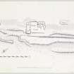
NT 359 360: Tower, Plora Burn. The remains shown on plan comprise the ruins of a tower-house, with associated outbuildings and terraces; all the buildings are now reduced to their lowest courses and are overgrown with vegetation.
The principal component is a group of buildings which occupies two sides of a courtyard. The tower stands at the NE end of the NW range and appears to have measured about 32' by about 22' overall. Part of the SW wall, exposed by excavation at the date of visit, was found to be built in rubble masonry laid in lime mortar, and had a thickness of 4'3". Much of the SE wall has been removed, perhaps by quarrying.
Even less remains of the other buildings of this group. The SW side of the courtyard is occupied by a building of two main apartments, measuring about 54' by about 20' overall, while a third building, measuring about 40' by about 20' overall, returns at right angles from the NW end of the SW range to join the SW wall of the tower.
An old roadway runs through the remains from NE to SW, and between this old road and the modern track that bounds the settlement on its SE side there are three terraces. At the SW end of the middle terrace there are the remains of a rectangular building measuring about 22' in width and having a present length of 26'; the NE wall has disappeared and the building may originally have been longer. These terraces are probably garden terraces, like the ones at Neidpath Castle (NT24SW 22).
About 50 yds SW of the main complex of buildings there are the remains of what was probably a corn-drying kiln. A considerable part of the kiln chamber remains, but is filled with debris. The present maximum diameter of the chamber, which is in the shape of an inverted cone, is 10'6"; the flue was on the SE side.
Immediately above the kiln, a small platform has been formed in the hill-side.
There are traces of further platforms and of enclosures outside the surveyed area, while about a quarter of a mile to the NE there may be seen the foundations of four rectangular buildings, which may have been associated with the tower.
Plora was a stead of the Forest of Ettrick, and there must therefore have been a settlement here in medieval times, but substantial buildings are unlikely to have been erected until the conversion of the forest leases to feus in the 16th c, to which period the tower may tentatively be ascribed. Latterly, at least, the property was divided, and there are references both to Wester Plora and to Easter Plora.
A drawing of 1838 suggests that at that time the tower was still roofed, but the outbuildings were ruinous.
RCAHMS 1967, visited 1959
NT 3610 3628. This site is generally as described.
Visited by OS (WDJ) 5 July 1961 and (BS) 5 September 1974
Possible 17th century garden.
N Hynd 1984
"The ruins of an old farm steading.."
Name Book 1859-60-3
Annotated Plora (in ruins), an enclosure with an unroofed building built into its N corner is depicted on the 1st edition of the OS 6-inch map (Selkirkshire 1859-60-3, sheet vi). The fragmentary remains of two walls are shown on the current edition of the OS 1:10560 map (1964).
Information from RCAHMS (SAH) 17 August 2000
Sbc Note
Visibility: This is an upstanding earthwork or monument.
Information from Scottish Borders Council

