
Knockdavie Castle


House (17th Century)
Site Name Knockdavie Castle
Classification House (17th Century)
Alternative Name(s) Stenhouse
Canmore ID 52866
Site Number NT28NW 9
NGR NT 2118 8822
Datum OSGB36 - NGR
Permalink http://canmore.org.uk/site/52866


- Council Fife
- Parish Burntisland
- Former Region Fife
- Former District Kirkcaldy
- Former County Fife
NT28NW 9 2118 8822.
(NT 2118 8822) Knockdavie Castle (NR) (remains of)
OS 6" map, (1967)
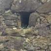
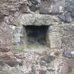
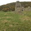
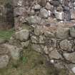
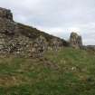
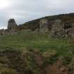
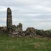
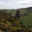
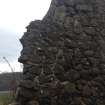
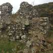
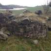
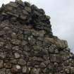
Knockdavie Castle is now a complete ruin. It has been a small 17th century house, oblong on plan, measuring externally 67 1/4' E-W by 19 3/4' with rubble-built walls 2'7" thick. On the N is a semi-circular projection for a turnpike stair.
D MacGibbon and T Ross 1887-92; RCAHMS 1933.
Knockdavie Castle, in a ruinous condition, is as described.
Visited by OS (W D J) 11 March 1959.
No change to previous field report.
Visited by OS (S F S) 17 December 1975.
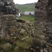
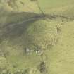
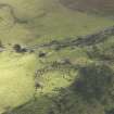
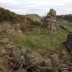
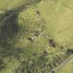
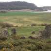
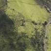
The monument consists of the remains of a small 17th century house which has had two floors and stands on a small piece of level ground on the shoulder of a hill. MacGibbon and Ross suggest the castle belonged to a Douglas in the 17th century, known as an opponent of the Covenanters. It is sited on a raised mound 1.5m high.
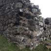
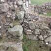
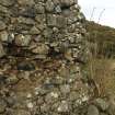
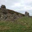
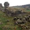
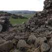
The building is approximately oblong on plan, measuring 22m E-W by 12m N-S. The masonry is random rubble with lime mortar. There are substantial upstanding portions in the east and west ends and the ground plan is easily read. The ground floor was divided into two by a partition wall. The NW angle stands to a height of c.5-6m from exterior ground level. Much of this west end has fallen into the interior. In the north wall are the lower courses of a turnpike stair. The west portion may have had a vaulted basement and the top of a debris blocked doorway can be seen in the south west wall. The south wall is fragmentary, the main portion surviving in
the south east. Here there is a door space and a mural cupboard.
There are the remains of a rectangular structure built onto the south east angle which drops to a lower level, measuring c.3.5m square. There are vague footings to the west and south of the castle, although there is insufficient detail to make out individual structures.
Imformation from Historic Scotland, scheduling document dated 20 January 1992.
Field Visit (26 May 1925)
No. 70 Knockdavie Castle
Knockdavie Castle, which stands on high broken ground almost 2 miles north-north-west of Burntisland, is now a complete ruin. It has been a small 17th century house, oblong on plan, lying east and west and measuring externally 67 ¼ feet by 19 ¾ feet, with rubble walls 2 feet 7 inches thick. On the north is a semi-circular projection for a turnpike stair.
RCAHMS 1933, visited 26 May 1925.

