 |
On-line Digital Images |
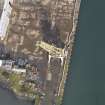
DP 143438 |
RCAHMS Aerial Photography Digital |
Vertical aerial view of 'Cromwell's Dyke' harbour, looking to the N. |
27/9/2012 |
Item Level |
|
 |
On-line Digital Images |
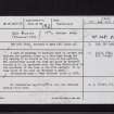
SC 2444136 |
Records of the Ordnance Survey, Southampton, Hampshire, England |
Burntisland Harbour, 'Cromwell's Dyke', NT28NW 30.2, Ordnance Survey index card, Recto |
1958 |
Item Level |
|
 |
On-line Digital Images |
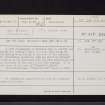
SC 2444137 |
Records of the Ordnance Survey, Southampton, Hampshire, England |
Burntisland Harbour, 'Cromwell's Dyke', NT28NW 30.2, Ordnance Survey index card, Recto |
1958 |
Item Level |
|
 |
On-line Digital Images |
SC 2444138 |
Records of the Ordnance Survey, Southampton, Hampshire, England |
Burntisland Harbour, 'Cromwell's Dyke', NT28NW 30.2, Ordnance Survey index card, Recto |
1958 |
Item Level |
|
|
All Other |
551 166/1/1 |
Records of the Ordnance Survey, Southampton, Hampshire, England |
Archaeological site card index ('495' cards) |
1947 |
Sub-Group Level |
|


