
Burntisland Harbour


Harbour (17th Century) - (19th Century)
Site Name Burntisland Harbour
Classification Harbour (17th Century) - (19th Century)
Alternative Name(s) Burntisland Docks; Cromwell's Dyke; Portus Cratiae; River Forth
Canmore ID 52799
Site Number NT28NW 30
NGR NT 23020 85414
NGR Description Centred NT 23020 85414
Datum OSGB36 - NGR
Permalink http://canmore.org.uk/site/52799


- Council Fife
- Parish Burntisland
- Former Region Fife
- Former District Kirkcaldy
- Former County Fife
NT28NW 30.00 centred 23020 85414
NT28NW 30.01 NT 2298 8568 'Herring Craig' pier
NT28NW 30.02 NT 2281 8562 'Cromwell's Dyke' harbour
NT28NW 30.03 NT 232 855 electric cranes
NT28NW 30.04 NT 2300 8542 hand crane
NT28NW 30.05 NT 23171 85416 East Dock, gates
NT28NW 30.06 NT 23104 85472 Ferry Pier, waiting room (Granton Ferry)
NT28NW 30.07 NT 23046 85479 Ferry Pier, office (Granton Ferry)
NT28NW 30.08 NT 23061 85317 Outer Harbour
NT28NW 30.09 NT 22858 85573 Inner Harbour
NT28NW 30.10 NT 23326 85502 East Dock
NT28NW 30.11 NT 23008 85608 West Dock
NT28NW 30.12 NT 23115 85233 East Breakwater, Beacon ('Burntisland 1')
NT28NW 30.13 NT 23029 85204 West Breakwater, Beacon ('Burntisland 2')
NT28NW 30.14 NT 22960 85344 Old West Breakwater, Beacon ('Burntisland 3')
NT28NW 30.15 NT 22998 85392 Old Ferry Pier, Beacon ('Burntisland 4')
NT28NW 30.16 NT 23031 85200 to NT c. 22936 85355 West Breakwater
NT28NW 30.17 NT 22963 85340 to NT c. 22874 85450 Old West Breakwater
NT28NW 30.18 NT 23110 85227 to NT c. 23198 85278 East Breakwater
NT28NW 30.19 NT 22994 85382 to NT c. 23064 85469 Ferry Pier and Slipway (Granton Ferry)
NT28NW 30.20 NT 23110 85561 West Dock, Engine House
NT28NW 30.21 NT 22950 85541 West Dock, Customs Watch House (Office)
For Cromwellian artillery fortification (East Head Fort) at NT 2306 8548, see NT28NW 29.
Not to be confused with the 'old pier' at the 'Bath House' (NT 2410 8621), for which see NT28NW 65.
For (former, adjacent) aluminium preparation plant (NT 226 862 to NT 229 862), see NT28NW 165.
For Granton Harbour (centred NT 23747 77701), the southern terminus of the Granton-Burntisland railway (train) ferry service, see NT27NW 28.00.
(Centred: NT 2295 8560) On a plan of Burntisland, dated about 1745, the harbour is shown occupying the same area as the Inner Harbour and the West Dock of the present harbour.
Information from J Elphinstone's Plan of Burntisland, scale 12 1/2 inches to 1 mile.
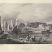
Harbour, formerly Portus Cratiae. Agricola found it 'the most commodious haven upon the north coast of the Forth'. At the time of the Charter of 1585 the harbour was being built and repaired and it is said to have been repaired again by Oliver Cromwell.
Name Book 1854.
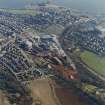
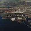
Burntisland harbour originally consisted of a basin protected by an island, and was described in 1703 as the 'best, largest and safest in the Forth'. It has a long history and served as the N terminal of a ferry across the Firth which ran at successive periods from Leith (NT27NE 57.00), Newhaven (NT27NE 76.00) and Granton (NT27NW 28.00). Today, however, nothing survives of archaeological interest, although the general outline of the place can be read into the modern layout. Thus, the quay on the W side of the Inner Harbour evidently conforms with the so-called 'Cromwell's Dyke' (NT28NW 30.02), while the street frontage N and NE of the dock as far as the SE end of Harbour Place (all of which is marked as 'Shore' in Wood's Town Atlas) represents the extent of the basin in these directions, but no structural remains may be identified in either locality as dating from before the middle of the 19th century. 'Cromwell's Dyke' is now masked by a shipbuilding yard and made ground, while the island (together with the piers that formed the harbour entrance) has been disguised by modern construction. The 'Shore' has made ground in front of it and the 'Herring Craig' has vanished from what is now the inner dock. The former ferry-pier, as it stood in 1895, has disappeared, its site being covered by the dock that opens to the NE out of the outer harbour; the existing ferry-slip dates from after 1895. The course of these changes may be followed by comparing Wood's plan of 1824, the 6-inch OS map surveyed in 1854, the 25-inch OS map surveyed in 1895, and OS plan NT2285-2385.
A Graham 1971.
This 19th-century dock and harbour complex was formerly the northern terminus of the train ferry service from Granton (NT27NW 28.00). It occupies the sites of the 16th century harbour and 17th century 'Cromwell's Dyke'.
B Lenman 1975.
Built 1876-1902 for coal exporting. A large harbour consisting of two wet docks and a tidal basin, into which the Burntisland shipyard launches. Interesting features incluse a wooden-jib post-crane and the former waiting room for the ferry from Granton, Edinburgh (NT27NW 28.00).
J R Hume 1976.
The Forth Ports Authority (FPA) was formed in 1968 to control the ports of Leith (NT27NE 57), Grangemouth (NS98SW 7), Burntisland (NT28NW 30), Methil (NT39NE 11), Kirkcaldy (NT29SE 44) and Granton (NT27NW 28), from headquarters at Leith. Between 1968 and 1983 over £40 million was spent on facilities. In 1982 over 27.5 million tonnes of cargo (of varied types) passed through the Firth of Forth. The FPA also controls the Forth Navigation Service, and is the pilotage authority. The FPA fleet provides towage at Leith, Granton and the Forth ports.
Situated on the South shore of Fife, the impounded Burntisland docks are chiefly important for the import of bauxite for the adjacent British Alcan alumina plant (NT28NW 165). To allow the discharge of larger vessels than was previously the case, bauxite is discharged over the sides of anchored ships into purpose-built barges of 8000t capacity, which are brought into the harbour to be unloaded by grab. Loads of up to 33,000t are handled from vessels of up to 38,000 dwt. Other commodities handled include caustic soda (imported) and alumina (exported).
Principal details are as follows:
Access: half-tidal entrance 18.2m wide. The gates are normally opened between 3hrs before HW and HW.
Area: total water 13.7ha, total land 15.0ha.
East Dock: water area 4.6 ha, quayage 443m. (No transit sheds).
The West Dock is leased to other port users, and a considerable area of land is available for industrial or oil-related development.
Total cargo handled in 1982 was 254,414t (244,062t inwards, and 10,352t outwards).
[Forth Ports Authority] 1983.
Following the closure of the adjacent alumina plant, this harbour is primatily used as a base for vessels engaged in marine construction works (including buoy-laying). It is also a base for recreational diving, and sees limited naval use, largely in connection with the adjacent degaussing range.
Information from RCAHMS (RJCM), 3 May 2006.
Project (2007)
This project was undertaken to input site information listed in 'Civil engineering heritage: Scotland - Lowlands and Borders' by R Paxton and J Shipway, 2007.
Publication Account (2007)
Burntisland, the best natural harbour on the Forth estuary, was known in ancient times as Portus Gratiae. In ca.1540 James V caused a bulwarks and piers to be constructed within it. The west quay was reputed to have been built by Cromwell and developments continued into the 19th century with shipbuilding and herring and whale fisheries. By 1836 Farnie’s dry dock, 200 ft long with a 44 ft wide gate, existed. Nothing of the early harbour now exists. In 1876 the West Dock was opened and continued in use until 1962 when its entrance was widened to 80 ft and new gates were fitted. Burntisland also exported coal in large quantities, mainly through the larger East Dock, which was opened in 1903.
A new industry began in 1917 when the British Aluminium Company opened a new plant for the processing of imported bauxite ore from West Africa, now demolished.
Today the harbour is operated privately by the Burntisland Shipbuilding Company, who have modernised it for use on oil industry projects and shipbuilding.In 1850 the harbour had the distinction of being the Fife terminal of the world’s first public train ferry from Granton designed by Thomas Grainger, but with an ingenious loading mechanism accommodating the state of the tide designed by Thomas Bouch.
The Leviathan ferry-boat, built by Robert Napier & Sons on the Clyde, was used only for goods wagons except on its opening day when it transported a railway carriage with passengers. In 1862 the North British Railway took over the ferry from the Edinburgh, Perth & Dundee. The ferry continued in use until the opening of the Forth Bridge in 1890.
R Paxton and J Shipway 2007
Reproduced from 'Civil Engineering heritage: Scotland - Lowlands and Borders' with kind permission from Thomas Telford Publishers.

