
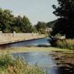
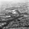
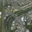
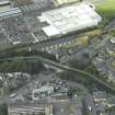
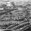
Edinburgh, Union Canal, Lanark Road Aqueduct


Aqueduct (Period Unassigned)
Site Name Edinburgh, Union Canal, Lanark Road Aqueduct
Classification Aqueduct (Period Unassigned)
Alternative Name(s) Edinburgh And Glasgow Union Canal; Slateford Road Bridge
Canmore ID 52572
Site Number NT27SW 101
NGR NT 2222 7086
Datum OSGB36 - NGR
Permalink http://canmore.org.uk/site/52572


- Council Edinburgh, City Of
- Parish Edinburgh (Edinburgh, City Of)
- Former Region Lothian
- Former District City Of Edinburgh
- Former County Midlothian
NT27SW 101 2222 7086
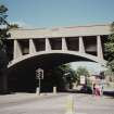
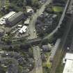
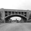
A concrete arch, carrying the Union Canal over Lanark Road.
J Gifford, C McWilliam and D Walker 1984.
This aqueduct is known as the Prince Charlie Aqueduct, possibly due to the fact that the Pretender set up camp nearby in 1745 whilst awaiting the surrender of the city of Edinburgh. It was rebuilt in 1937 and, when viewed from the Slateford Road, over which it carries the canal, can be seen to constitute one of the better examples of concrete bridges of its period. A flight of steps leads down from it.
H Brown 1997.
This aqueduct is marked on the 1st Edition of the OS 6-inch map (Edinburghshire 1855, sheet 6), as well as on the current edition of the OS 1:10000 map (1988) and the OS 1:10000 raster map (ND).
Information from RCAHMS (MD) 1 February 2001.

