
Edinburgh, High Street, Luckenbooths


Shop(S) (14th Century)
Site Name Edinburgh, High Street, Luckenbooths
Classification Shop(S) (14th Century)
Alternative Name(s) Buith Raw
Canmore ID 52535
Site Number NT27SE 7
NGR NT 2572 7361
Datum OSGB36 - NGR
Permalink http://canmore.org.uk/site/52535


- Council Edinburgh, City Of
- Parish Edinburgh (Edinburgh, City Of)
- Former Region Lothian
- Former District City Of Edinburgh
- Former County Midlothian
NT27SE 7 2572 7361.
(Name: NT 2572 7361) Luckenbooths (NR) (Site of)
OS 1/1250 plan, (1970)
This name applied to a four-storeyed tenement, mostly timber fronted, which stretched along the N side of St Giles' Cathedral, being separated from it by a narrow passage in which, between the buttresses of the church were placed the open stalls, called "krames". When first built, in 1440, the tenement was of 2 storeys and was called the "Buith Raw"; it was heightened in the 16th or 17th century. The Luckenbooths were demolished in 1817, to widen the High Street.
RCAHMS 1951.
No trace. No further information.
Visited by OS (J L D) 25 December 1953.
REFERENCE;
Sources: Dean of Guild Bundle 1811 25.4.1811
Pet. of William Henderson, Sec to British Linen Co
Luckenbooths shop next to Byres Close
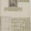
Plans and elevation encl fine. Usigned. 4 floors and shops.
Sources: Dean of Guild Bundle 1811 12.9.1811
Pet of James Stevenson, merchant
Luckenbooths
Complicated set of plans and elevations & sections
At least one elevation is of complete block
Unsigned
Source: Dean of Guild Bundle 1813 January-June 3.6.1813
Pet. Robert Neil, merchant
Luckenbooths
Alterations to shop front
Plan & elevation, unsigned.
Sources: Dean of Guild 14.4.1814
Pet. Messrs Boyd and Hogg.
Opposite the Luckenbooth.
Minor alterations - shop front.
Plan and elevation, unsigned.
Publication Account (1951)
81. The Luckenbooths, High Street.
This.name was given to a four-storeyed tenement, timber-fronted for the most part, which stretched along the N.side of St. Giles' Church being separated from it by a narrow passage in which, between the buttresses of the church, were placed the open stalls that were called "krames." When first built, in 1440, the tenement was of two storeys only, and was known as the "Buith Raw"; it was heightened in the 16th or 17th century. The intrusion of this building into the High Street and the consequent narrowing of the thoroughfare was a long-standing cause of resentment, the earliest recorded objector having been William Dunbar, the poet; the Luckenbooths, however, continued to stand until 1817, when they were demolished.
RCAHMS 1951
Publication Account (1981)
This name was given to a row of four-storeyed tenements which were timber-fronted, located on the north side of St. Giles Church. Only a narrow passage separated the Luckenbooths from the buttresses of the church. When first built, perhaps as early as 1386 (Miller, 1886, 371), the tenements were only of two storeys and were called the Buth Raw (RCAM, 1951, 127). The intrusion of the Luckenbooths and the tolbooth on to the High Street caused resentment, for it greatly narrowed passage in that thoroughfare and consequently they were swept away along with the tollbooth in 1817.
Information from ‘Historic Edinburgh, Canongate and Leith: The Archaeological Implications of Development’ (1981).
Watching Brief (30 March 2006 - 30 November 2006)
An archaeological watching brief was undertaken on the machine and hand excavation of an area of the Royal Mile, extending from the George IV Bridge at the North end of the High Street to Cockburn Street to the south of the High Street in Edinburgh's Old Town. The works were carried out between 30th March and 24th November 2006 and were the culmination of road improvement works that began in 2005/6 on George IV Bridge. Six cellar walls, a substantial multi phased wall postulated to be the remains of the old Tolbooth and Luckenbooths of medieval or post-medieval date and a Well were identified during the extensive road works on the High Street. No physical remains of the documented Guardhouse which was originally located in the middle of the High Street were uncovered during the works.
AOC Archaeology 2008 (S. Lynchehaun, M. Cross)

