
Edinburgh, Canongate, Girth Cross


Boundary Marker (Period Unassigned)
Site Name Edinburgh, Canongate, Girth Cross
Classification Boundary Marker (Period Unassigned)
Alternative Name(s) Girs Cross; Grass Cross; Holyrood Abbey
Canmore ID 52358
Site Number NT27SE 33
NGR NT 26739 73910
Datum OSGB36 - NGR
Permalink http://canmore.org.uk/site/52358


- Council Edinburgh, City Of
- Parish Edinburgh (Edinburgh, City Of)
- Former Region Lothian
- Former District City Of Edinburgh
- Former County Midlothian
NT27SE 33 2673 7391.
(NT 2673 7391) Girth Cross (NR) (site of)
OS 25"map, (1968)
The Girth Cross, which has also been called the "Abbey" or "South" Cross at various times, marked the W limit of the Girth of Holyrood, the greatest sanctuary in Scotland, and the last to disappear. It is shown on a map of 1573 as an ornamental shaft elevated on a flight of steps and was extant until after 1767.
RCAHMS 1951; H Hannah 1927.
No trace.
Visited by OS (J L D) 25 December 1953.
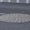
See NMRs Historical File, under The Canongate - The Girth Cross. Entry consists of one page of information with two pen ank ink sketches showing the Cross and the pattern of paving blocks that is said to mark the position of the Cross.
In the frame room is Gordon of Rothiemay's Map, 1647.
Publication Account (1951)
THE GIRTH CROSS AND HOLYROOD SANCTUARY.
In front of the Abbey gatehouse rose the Girth Cross, also known as the South or Abbey Cross to distinguish it from another cross standing further W. Until after 1767 the Abbey Cross marked the W. limit of the Girth of Holyrood, the greatest sanctuary in Scotland and the last to disappear (13). The boundaries of the sanctuary were extensive, but the habitations in which the later refugees dwelt were clustered round Holyrood; and although those which stood in St. Anne's Yards. to the S.E. of the Palace have long since disappeared, some of the others still survive in the triangular group of old buildings, known as Abbey Strand, that stand between the site of theWatergate and the access to the gatehouse.
RCAHMS 1951
(13)On the sanctuary of Holyrood see O.E.C., xv, pp. 55-98.

