
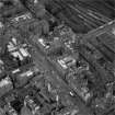
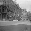
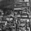
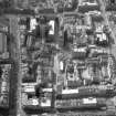
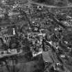
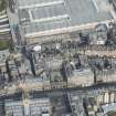
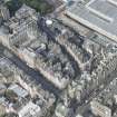
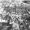
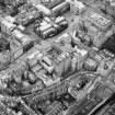
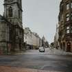
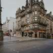
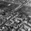
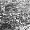
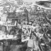
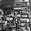
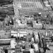
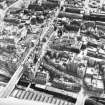
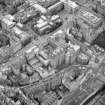
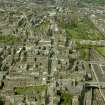
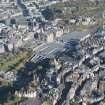
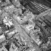
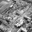
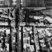
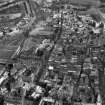
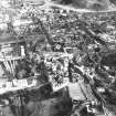
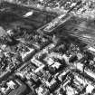
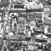
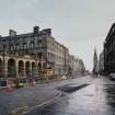
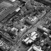
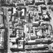
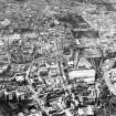
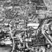
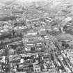
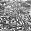
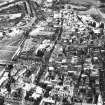
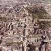
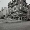
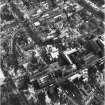
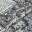
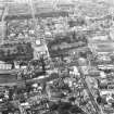
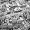
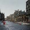
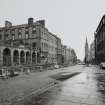
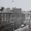
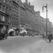
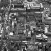
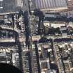
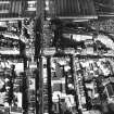
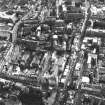
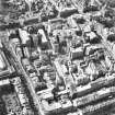
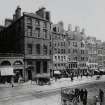
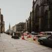
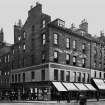
Edinburgh, High Street, North Bridge To Lawnmarket, General


General View
Site Name Edinburgh, High Street, North Bridge To Lawnmarket, General
Classification General View
Alternative Name(s) Currour's Close; Royal Bank Close; St Ann Street; Slater's Close; Lee's/leye's Close; Cranston Close; Tron Picture House
Canmore ID 52255
Site Number NT27SE 229
NGR NT 25821 73625
Datum OSGB36 - NGR
Permalink http://canmore.org.uk/site/52255


First 100 images shown. See the Collections panel (below) for a link to all digital images.
- Council Edinburgh, City Of
- Parish Edinburgh (Edinburgh, City Of)
- Former Region Lothian
- Former District City Of Edinburgh
- Former County Midlothian
REFERENCE:
SCOTTISH RECORD OFFICE
Relating to Royal Bank Close:
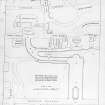
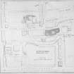
RHP 5556 R Burn 1802 -plan and elevation for improveing entry to the Royal Bank of Scotland (possibly located near Tron Church/Hunter's Square).
SCOTTISH RECORD OFFICE
Relating to Currour's Close:
Jedge Warrant in favour of Mark ker for alterations to the entries and passages of the above property.
1577 GD 90/5/2
REFERENCE:
Sources: Dean of Guild Bundle 1811 28.2.1811
Pet. of Charles Ritchie, Ironmonger
High Street north side to east of Anchor Close, also Swans Close
Alterations to shop front - (wrought?) iron balcony
Balustrades shown below windows on third floor
Plan showing relative positions of Anchor &Swans Close
Plan and elevation of shop & front to High Street
Stair next to shop. "Stair to ware rooms belonging to the Society of Gents' servants"
Sources: Dean of Guild Bundle 1813 January-June 29.4.1813
Pet. James Hay, Ws and others, proprietors of tenement in bishops Land, north side of High Street
"said tenement of land having been burnt down by the later fite and become ruinous"
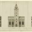
Seven plans of all floors and Elevation, all signed by Thomas Bonnar, 16th March 1813
Sources: Dean of Guild Bundle 1813 January-June 27.5.1813
Pet. James Bridges WS.
405 High Street.
Plan showing alterations and repairs. Unsigned.
Sources: Dean of Guild 18.11.1813
Pet. Andrew Steele, WS, and Robert Bayne, merchant, Leith.
Shop in High Street to west of Carrubbers Close.
Minor alterations to shop front.
Elevation, initialled.
Sources: Dean of Guild 9.12.1813
Pet. James Hay, WS, and others
West End of Bishops Land
To repair and reconstruct a ruinous tenement which appears to estend over part of
Carrubbers Close
Plan and section enclosed. signed J.B., 11 Aug 1813
[Thomas Brown]
Sources: Dean of Guild 14.4.1814
Pet. Messrs Boyd and Hogg.
Opposite the Luckenbooth.
Minor alterations - shop front.
Plan and elevation, unsigned.
Sources: Dean of Guild 14.4.1814
Pet. William Walker and others
Head of Byres Close - High Street (fronting)
Minor alteration - stair interior
Plan and elevation unsigned - in same hand as petition of Boyd & Hogg, High Street,
14.4.1814
Sources: Dean of Guild 9.6.1814
Pet. Alexander Henderson, seedsman
Hogs Land, North side of High Street
Elevation of shop front, unsigned
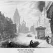
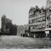
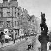
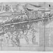
Edinburgh, St Ann Street.
Street formed c.1770 and descended steeply from Prince's street immediately West of North Bridge. It was suppressed in 1816 by town council who built a new terrace of houses set back 12 ft from bridge and intended to improve the view of the Register House from it. It has since been suppressed.
Edinburgh, St Ann Street.
NMRS REFERENCE.
Historical File:
6 pages of text giving details of evolution of St Ann Street, filed under: 'NORTH BRIDGE STREET NEW BUILDINGS'.
NMRS REFERENCE.
Historical File:
24 pages of text giving details of North Bridge and refernces to St Ann Street, filed under: 'NORTH BRIDGE [NEW] AND STREET'.
NMRS Notes.
Possibly former site of Slater's Close.
NMRS REFERENCE
Slater's Close
Ran north from the Square, (Milne's Square) sold to the town probably in connection with the building of the old North Bridge.
NMRS REFERENCE
Lee's or Leye's Close
Lay at the East or the NE corner of Milne's Square; lost in the construction of the Old Bridge.
NMRS HISTORICAL FILE
Milne's Square.
Lee's Close, Slater's Close, Cranston Close all lost in construction of North Bridge.
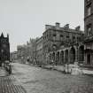
Edinburgh, Lawnmarket, 'Old House'.
LOR/EARLSHALL CEILINGS/3: Fragment of /1.
LOR/EARLSHALL CEILINGS/4: Survey of decorated panelling at the 'Old House, Lawnmarket'.
Insc: 'Painted ceiling of Old House, Lawnmarket, recently pulled down' [back, in pencil].
Floral, bird and animal designs.
Ink and paint on linen. n/s n/d.
LOR/EARLSHALL CEILINGS/5: F.S. damask design for stencilling - at Earlshall??
Pencila and paint on green paper.
n/s n/d n/insc.
4 pages relating to this.
NMRS REFERENCE:
Printroom:
Soc Antiq Scot - Sir Daniel Wilson's collection of drawings etc. 'Old Edinburgh' vol 1-5 engravings.
Unable to locate at time of upgrade 15.2.2000.
NMRS REFERENCE:
Plans:
City Architect's plan store, drawer 1000 contains:
a) Photograph of the back of the buildings on the West side of the old Shakespear Square, prior to the building of the 'North Bridge Station Hotel' shews Waterloo Place and the Calton Hill Monuments, and in the foreground the roof of the Fruit and Vegetable Markets.
National buildings Record: photostat copy of (a) above.
Unable to locate at time of upgrade 15.2.2000.

