
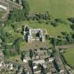
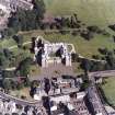
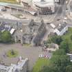
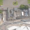
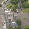
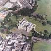
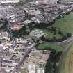
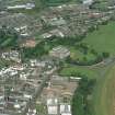
Edinburgh, Abbey Strand, Abbey Sanctuary


Building (16th Century)
Site Name Edinburgh, Abbey Strand, Abbey Sanctuary
Classification Building (16th Century)
Alternative Name(s) Abbey Strand, Eastern Building
Canmore ID 52248
Site Number NT27SE 222
NGR NT 26796 73937
Datum OSGB36 - NGR
Permalink http://canmore.org.uk/site/52248


- Council Edinburgh, City Of
- Parish Edinburgh (Edinburgh, City Of)
- Former Region Lothian
- Former District City Of Edinburgh
- Former County Midlothian
Publication Account (1951)
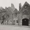
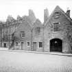
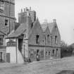
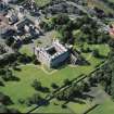
90. Abbey Strand.
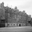
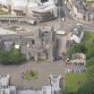
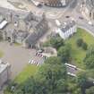
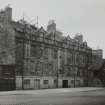
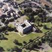
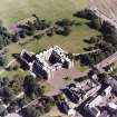
It will be convenient to begin the Inventory of domestic buildings at the E. end of the Canongate. On the N. side of Abbey Strand* there are two contiguous 17th-century tenements, which Lord Rosebery acquired in 1935 and presented to the State in order to ensure their preservation. The E. member of the pair, which is known as "Lucky Spence's house," (l) looks older than its neighbour although it is actually the more recent of the two, the W. building having undergone modernisation from time to time.
WESTERN BUILDING. The architectural history of this building dates back to the end of the 15th or the early years of the 16th century. In its first form it stood three storeys and an attic in height, was oblong on plan, and measured 76 ft. from E. to W. by 24 ft. from N. to S. The ground floor may have been cellarage and, as at present, there may have been a through transe. Each of the upper floors accommodated two dwellings of hall-and-chamber character, those on the first floor being entered from external stone stairways. Each stair was carried on a segmented arch buttressed against the N. wall of the building, and. gave access to turnpikes in corbelled and engaged rounds which led to the houses on the upper floor. The doorways to these turret stairs had delicately-moulded jambs of a character assignable to the first half of the 16th century. The E. doorway is still in position, but the one on the W. was taken down and rebuilt to serve as an entrance to a common turnpike formed in later years (infra). Subsequently both halls had direct access from the street on the S. by forestairs placed at the E. end of each dwelling. One of these stairs, that on the E. side, is still in use. On the E. and W. walls the remains of water-tabling indicate that there were wooden galleries on these elevations, and it seems possible that similar galleries also occurred on the N. side. The original windows appear to have been of small size, and to judge from the existing evidence on the S. elevation near the N. end, at the first-floor level, they seem to have been set some considerable height above the floor. One original window, now built up, is noticeable in the W. gable above the remains of the water-table course. Immediately above this window the line of the old crow-stepped gable can still be traced, and at the other end of the building a projecting skew-put gives the line of the wall-head level. The main feature within each hall was a large fireplace, with moulded jambs and lintel, which measured 7 ft. 9 in. long by 4 ft. 5 in. high.
The building suffered in the general conflagration of 1544 and on its reconstruction it was extended 11ft. northwards. From the outer wall of this extension there projected a turret and turnpike which became the common stair of the reorganised dwellings. At this period, too, a further extension was built to the E.; this was 21 ft. square on plan and two storeys and a garret in height. The ground floor contained a kitchen with an arched fireplace of late 16th century type which may originally have belonged to the manse of the chaplain of St. Leonard's Hospital.** This extension became the nucleus of the eastern building (infra).
Various alterations and enlargements in the fenestration of the S. elevation have upset the 17th century appearance of this facade. Especially notable, however, are two groups of large windows on the first-floor level, which belong to the reorganisation carried out after the partial destruction of 1544.They have moulded jambs and were originally furnished with leaded lights and oak shutters. Each window was protected by a projecting iron grille, as indicated by the bar-holes in the masonry. The windows with the plain chamfers are of late 17th century date and bespeak a reorganisation of that time, when pine panelling and heavy plaster cornices were introduced into the rooms. Apparently there were at least two large windows on the second floor, each disposed above its neighbour of the first-floor level; otherwise the fenestration appears to have been small. At the centre of the building at this level there was a moulded stone housing for a coat of arms. In the early part of the 19th century the building was heightened by a storey, and on the street frontage the ground-floor elevation was reset and faced with freestone ashlar.
EASTERN BUILDING. This building appears to have been constructed in the first half of the 17th century. As has already been said the plan, which is somewhat L-shaped, incorporates the 16th century addition to the W. building. The block to the E. is 64 ft. long by 21 ft. wide and is set with its crow-stepped gable to the street, an arrangement which gave rise to the triple gable of this facade. This street elevation has been reset on the original lines by the Ministry of Works, and it incorporates an arched coach-entrance of a type similar to those that are to be seen on the back elevation of White Horse Close (No. 93). A noticeable feature on the E. face is the fireplace projection, and at the S.E. corner there is the indication of another building which ran E. and linked up with the garden wall of the Palace. The windows on the first-floor level are of 17th-century character and have chamfered rybats; those on the ground floor are for the most part restorations. There are two entrances to the first floor of this building from the outside. The one giving access from the street is by the old stairway which served the easternmost house on the first floor of the western building; this stairway is partially roofed and forms an entrance porch. The other entrance is by a forestair on the W. side of the E. wing, the head of this stair being furnished with a wood-boarded and slated porch. Within the building the first room on the main floor had a wooden barrel-vaulted ceiling, and in the S. room of the E. wing there is an enriched plaster ceiling divided into six compartments at every corner of which there is a circular panel. Some wooden beams bearing painted decoration, which came from Caroline Park (2), have been built into the corresponding room on the floor below.
RCAHMS 1951, visited c.1941
(1) Allan Ramsay, Poems (ed. 1721), i, pp. 33-9. (2) Inventory of Midlothian and West Lothian, No. 41.
*'Strand' originally meant a gutter.
**This manse, which is mentioned in the Accounts of the Lord High Treasurer for 1541, was burned by the English in 1544 and was still ruinous in 1561, but had been rebuilt by 1570 (O.E.C., xxiii, pp.122-5.
Standing Building Recording (13 May 2002 - 24 May 2002)
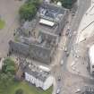
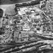
NT 2678 7393 A programme of standing building recording was undertaken at Abbey Strand in May and June 2002. This involved the compilation of a photographic record and baseline architectural investigation of the buildings on the N side of Abbey Strand. Four main phases of development were identified:
Phase 1 Early 16th century
Phase 2 Early 17th century
Phase 3 Pre-1647
Phase 4 Mid- to late 17th century
These phases were sub-divided into periods of a decade each.This survey is not a complete record of the building complex,and is intended as a baseline record and as a framework for any further recording.
G Ewart, D Gallagher, & D Stewart 2002
Sponsor: Historic Scotland
Kirkdale Archaeology
Standing Building Recording (10 August 2011 - 18 November 2011)
NT 2679 7393 A programme of work was carried out 10 August – 18 November 2011 on the adjoining buildings on the N side of Abbey Strand between the foot of the Canongate and the precincts of the Palace of Holyroodhouse.
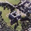
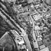
Period 1 (1490–1570) Abbey Strand lies in the triangular space at the foot of the Canongate. Here the High Street led both to the palace and to the Watergate, the principal entry to the city from the E. The building lay in the precinct of Holyrood and its sanctuary but outside the main ceremonial gate of the abbey. The main block consisting of a three-storey building plus a probable attic space, 23.3m long by 7.5m wide, was built during this period. The principal N–S partition running through the building, currently denoted at ground level by the W wall of the pend, making two units, the E slightly larger than the W. Both units had a turnpike stair in their NE corner. The E one partially survives but the W one no longer exists. The surviving elaborate first floor door faces N. An arch in the room below may have supported a stair. There appears to be a blocked door on the ground floor opening from the internal E stair.
Period 2 (1570–c1630) During this period the medieval building was completely transformed for use as a high status house for courtiers. This building and the adjacent abbey gatehouse would have formed the dominant group of buildings before the entry to the palace. The entry to upper floors was from the garden to the N, which was adjacent to the royal privy garden.
Period 3 (c1630–1700) This was a period of prosperity and expansion during which the building continued to be used as a high status dwelling. The main block and the pend were extended c3.4m N. The SW–NE angle of the W wall of the extension suggests that it was constructed against an adjacent structure or boundary. The turnpike stairs continued to be used, with their N-facing doors providing access to the first floor of the N extension.
Period 4 (c1700–1916) An extra storey was added to both the main block and the N extension. The W turnpike stair was removed and the N stair built. The door from the turnpike stair was reused as the front door for the new stair. The NE jamb was added and the alteration of windows to doors at the E end of the N face of the N extension allowed access. The building was mainly used for accommodation and service activity during this period, beginning with the provision of housing for some of the respectable, though comparatively impoverished, gentry that sought refuge from imprisonment for debt in the Holyrood sanctuary. The area then declined following the construction of the New Town in the late 18th century, as the Old Town was abandoned by respectable society. The area became increasingly industrialised and Abbey Strand was subdivided to provide cheap accommodation for workers. The ground floor had a number of taverns.
Period 5 (1916–35) The building was renovated by the architect William Ross and the first clear internal plan of the building produced. The exterior was restored, the density of occupation in the tenement reduced and the ground floor public houses closed. The top floor of the main block and N extension were also removed and the size of the attic reduced. A small number of windows were altered, with those on the third floor converted to dormers.
Period 6 (1935–63) The building was declared unfit for human habitation, internal partitions were removed and the NE jamb demolished. Major renovations were also carried out on the buildings to the E of the main block, including the replacement of stonework around windows and doors, and work on the roof over the kitchen, shop and N extension. Most of the Period 3 roof beams were retained but the sarking and slates were replaced.
Archive: RCAHMS (intended)
Funder: Royal Collection Enterprises Ltd
Gordon Ewart, Kirkdale Archaeology
Dennis Gallagher,
2012
Dendrochronology
NT 26796 73937 An historic building recording programme at Abbey Strand by Kirkdale Archaeology for the Royal Collection Trust serendipitously coincided with the SESOD project. Eight oak timbers were analysed for SESOD. This assemblage is of very mixed character with little intra-assemblage cross matching, no doubt reflecting the complex evolution of the building. Two or possibly three, of the Abbey Strand SESOD samples are from oak sled runners re-used in the building: ABS003 and ABS016 have been dendro-dated and are Norwegian in origin. Unfortunately, there is no sapwood on either sample. They were made from trees felled sometime after AD 1537. The only other dated Abbey Strand SESOD sample is timber ABS142 with a felling date in the winter of AD 1580/81. This matches best with Danish reference data, unusual given most 16th-century dendro-dated oak timber in Edinburgh comes from Norway. The five other SESOD samples from Abbey Strand did not match each other or any other oak samples from the site and could not be dated. They include younger oaks than represented in the Scandinavian material and there may be some native Scottish oak amongst them. Two other oak timbers from the Abbey Strand project have been dated by Anne Crone and proved to be Scandinavian imports of 15th- and 16th-century date (Crone 2021): all Abbey Strand dendrochronological results will be presented in the site publication as well as in the SESOD project publication. See also the SESOD overview (p6).
Archive: NRHE (intended)
Funder: Historic Environment Scotland
Coralie Mills – Dendrochronicle
(Source: DES Volume 23)

