
Edinburgh, Flodden Wall, Telfer Wall


Town Wall (Period Unassigned)
Site Name Edinburgh, Flodden Wall, Telfer Wall
Classification Town Wall (Period Unassigned)
Alternative Name(s) Telfer Wall; Old City Wall
Canmore ID 52145
Site Number NT27SE 14
NGR NT 25 73
Datum OSGB36 - NGR
Permalink http://canmore.org.uk/site/52145


- Council Edinburgh, City Of
- Parish Edinburgh (Edinburgh, City Of)
- Former Region Lothian
- Former District City Of Edinburgh
- Former County Midlothian
NT27SE 14 25 73
Town Wall components:
NT27SE 14.01 NT 2530 7330 Gateway (West Port)
NT27SE 14.02 NT 25341 73222 Tower (Flodden Tower)
NT27SE 14.03 NT 2572 7324 Gateway; Town Wall (Bristo Port)
NT27SE 14.04 NT 2590 7331 Gateway (Potterrow Port)
NT27SE 14.05 NT 2619 7354 Gateway (Cowgate Port)
NT27SE 14.06 NT 2614 7370 Gateway (Netherbow Port)
NT27SE 14.07 NT 2571 7324 Gateway (New Port)
NT27SE 14.08 NT 2570 7312 Gateway (Forrest Road)
NT27SE 14.09 NT 261 737 Gateway (Leith Wynd Port)
NT27SE 14.10 NT 260 738 Gateway (College Church Postern)
NT27SE 14.11 NT 259 738 Gateway (New Port)
For Roman coin, apparently found in removal of this wall, see NT27SE 53.
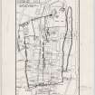
The old town had, in turn, three walls. The very early one enclosed little more than the High Street and the closes and wynds turning off it, and as the town grew it provided no protection for the mass of the citizens. When in the year 1513 news reached them of the Scots defeat at Flodden, frantic efforts were made to enclose a much greater area with the hasitly-erected defence we now call the Flodden Wall. By the beginning of the 17th century not only was this wall showing signs of age and of its too hurried construction, but once again the city had outgrown it, so a third and final fortification, Telfer's Wall, took in more ground to the south, including George Heriot's Hospital.
Over the years almost all traces of these walls with their "ports" have disappeared. Recently, on ground cleared ready for the building of their new museum, the Society of Antiquaries replaced the last remaining fragment of Flodden Wall adjoining Bristo Port with a row of concrete posts, while a few years earlier a length of wall which had been encased within extensions to the Royal Scottish Museum, was at first shown among other exhibits, then boxed in and the lower courses are still preserved in the basement.
In contrast, the Heriot Trustees have respected and preserved the last surviving corner tower of the Flodden Wall at the head of the Vennel and to the south of it, along Heriot Place, a long and imposing stretch of Telfer's Wall at its full height. Needing every yard of their ground they have had to build hard against the old tower, somewhat dwarfing it when seen from the south. But at least it is still intact with its original embrasures for defence-although incongruously during last century a large ornamental window was knocked in it 'by order of the Council'.
E S Towill.
Scheduled as 'Edinburgh Town Wall, Flodden wall and Telfer Wall, Heriot Place... a tower of the Flodden Wall and a section of the Telfer Wall, the remains of parts of two of Edinburgh's late medieval town walls, dating to circa 1513 and 1630 respectively. The tower lies on the side of the Vennel at NT 2534 7322, and the section of the Telfer Wall adjoins the tower and runs SE down the E side of Heriot Place from NT 2535 7322 to NT 2545 7308'.
Information from Historic Scotland, scheduling document dated 4 February 2003.
See NMRS Historical Filed, The Telfer Wall, Old City Wall
EXTERNAL REFERENCE:
City Architect's Plan Store
Drawer No.54 Tracing from a drawing prepared by Mr Gow dated, December 2, 1893 for repairs to the wall.
Publication Account (1951)
60. The Telfer Wall.
An account of the building of the Telfer Wall- really an extension of the Flodden Wall (No. 59) -together with a description of its course will be found in the Introduction ([RCAHMS 1950] p. lxv). All that now survives of it is a stretch running S.E. for a distance of 130 yds. along the E. side of the Vennel from the tower mentioned at the beginning of No. 59. It is rather thicker than the Flodden Wall, and is built of much larger stones. From the demolished part material has been taken and re-used to construct the S. end of the W. boundary-wall of Heriot's Hospital, which follows the course of the Telfer Wall.
RCAHMS 1951

