
Edinburgh Castle, Princes Street Gardens, Wellhouse Tower


Tower (14th Century)
Site Name Edinburgh Castle, Princes Street Gardens, Wellhouse Tower
Classification Tower (14th Century)
Canmore ID 52072
Site Number NT27SE 1.12
NGR NT 25087 73618
Datum OSGB36 - NGR
Permalink http://canmore.org.uk/site/52072


- Council Edinburgh, City Of
- Parish Edinburgh (Edinburgh, City Of)
- Former Region Lothian
- Former District City Of Edinburgh
- Former County Midlothian
Wellhouse Tower (NR) (Ruin) (NAT).
OS 1/500 plan, (1895); OS 1/1250 plan, (1947).
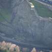
Built in 1362. All that remains is a stretch of walling extending some 50 feet NE from a circular bastion adjoining the NE corner of the Tower itself. Little more than the E end of the Tower remains, being two storeys in height. (RCAHMS 1951).
Visited by OS(JLD) 22 October 1953.
(NT 2508 7361). Portions of this Tower remain at the foot of the Castle crags.
The stretch of walling described above, has been stated on Midlothian 3 NE 1.29 as being a remnant of the Castle Wall, and does not appear to constitute part of the Tower itself.
Visited by OS(JLD) 29 December 1953.
As described in previous field report.
Visited by OS(SFS) 10 November 1975.
NT 2511 7362 On the top of the NW corner of the first recess in the path up from the Water Tower is a corner block, of a string-course, laid upside down. The block is 0.15m thick, by 0.31m wide and around 1.24m long. Half of the edge is chamfered and carved with a series of equilateral triangles.
C A-Kelly 2000
Publication Account (1951)
The Well-House
The lowest part of the Castle is the 14th century Well-House Tower, which stands in West Princes Street Gardens and covers the N side of the base of the Castle Rock. It was supplied by a spring, known as St Margaret’s Well, which, in 1867, was led to a fountain placed at the junction of the tower and the end of the wall mentioned on p. 13 [RCAHMS 1951]. Up to 1821 the spring supplemented the draw wells of the castle (RCAHMS 1951 en.41). The tower itself stands a little apart from the Rock, leaving room behind for a covered passage, which has evidently been walled in and closed by gates at either end.
When the gardens were laid out in the time of George IV an accumulation of soil was removed from the back of the Tower to make way for a path, and the covered way was then exposed with the sally-port at its W end. This was secured by a draw-bar and other protection. The port opened out inside a chasm in the rock about 20ft wide in which a scrambling stair rose to a fissure which is crowned, about half-way up the rock and immediately above the Tower, by a platform known as the Crane Bastion, or popularly as Wallace’s Cradle [NT27SE 1.13]. A human skull, much shattered as though by a fall, was found on the steps near some other bones. A trench on the E side of the Tower disclosed a deal coffin containing the skeletons of a male and two females, thought to be the remains of a man named Sinclair and his two sisters who, in 1628, had been drowned in the North Loch for incest [NT27SE 1.30]. In and about the tower were found coins of Oliver Cromwell and Edward III, as well as a single penny thought to date from the reign of Edward I. Numerous fragments of bomb shells, and a 48lb shot found embedded in a breach in one wall, bore witness to the battering sustained by the tower in 16th century and later sieges (en.42).
Little more than the E end of the Tower stands today, the maximum height being two storeys. On plan the structure has consisted of a main block, running E and W and measuring externally about 38 ft by 30 ft, from the NE corner of which a wing about 10 ft square, apparently intended to contain the well, projects diagonally, the opposite corner on the SE being similarly offset, not for symmetry but to permit access from the upper floor of the main block across the top of the covered way. The masonry is rubble, quarried on the spot, relieved by imported dressings of freestone. The upper part of the outer walls of the wing are set back in a manner characteristic of the 14th century. The only windows left are two narrow lights with chamfered jambs and lintels facing the covered way.
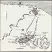
The plan and construction of the building show that it combined the functions of well-house and gatehouse (p.3). A gatehouse implies an enclosure, and there is evidence for an enclosure or apron in front of the Castle more than a quarter of a century before this tower came to be built. In the sheriff’s account for the year 1336-7 (en.43) the first entry for the constabulary of Edinburgh runs "De mota castri de Edenburghe cum quadam placea Warda ibidem, que solebant valere xiij s. per annum, non respondet quia dicta mota edijicatur, et dicta placea iacet in communi ante portam, ita quod nihil potuit inde levari." The mota is, of course, the Castle Rock itself and the Warda is evidently an enclosure* in front of the gate. Both Rock and enclosure had apparently been previously let for grazing, but the former was now being built on while the latter had become a waste, possibly "propter destruccionem guerre "-the same reason as caused the revenue from other subjects to fail for the time being. An entry in the Warden's accounts for the year 1339-40 (en.44), which speaks of "making modewalls [i.e. earthen ramparts] around the castle", indicates the nature of the boundary if it does not actually' specify its repair.
The construction of the Well-House Tower in 1362 was probably the prelude to rebuilding the wall of the enclosure in stone, and the area covered by the enclosure itself at this stage can be inferred. On the N. its wall started at the Well-House Tower and ran N.E., skirting the S. shore of the North Loch for a distance of some 850 ft.; at this point it turned S., ascended the Castle Bank and crossed the Castle Hill at the water-reservoir. From there it descended the S. side of the Castle Bank, on the line taken by the upper end of Castle Wynd, as far as the S. side of Johnston Terrace, where it turned W., half-way down the slope, to meet the wall of the Barras (en.45). There is also some reason for believing that an extension of this S. section of the enclosure wall ran eastwards to join up with the S. boundary ofthe burgh. The descriptive epithets "sub muro castri" and "subtus murum castri" came to be applied to the suburb of Grassmarket, which grew up immediately to the S., and it is tempting to believe that the "murus castri" referred to was the combined S. wall of the ward and its eastward extension.
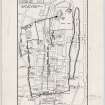
The fact that in 1530 two burgh properties, one situated in Grassmarket and the other on the Castle Hill, are said to be bounded by the Castle Bank, in one case on the N., and in the other on the W., rather suggests that the enclosure was by this time no longer complete. This inference is supported by the view of 1573 (Fig. 61) and by Slezer's drawing of ante 1697, to the extent that no wall is shown on the S. while that on the E. is no more than a garden wall; again, the view of 1544 (Fig. 59), drawn from such a position that the N. stretch of the wall is hidden, does not show the stretch on the E. which ran S. from the North Loch to the Castle Hill. Gordon's map of 1647 (Fig. 67), on the other hand, shows the N. stretch as angled, and its return on the E. as the outer wall of a lane terminating at the uppermost houses on the N. side of the Castle Hill; while from the houses on the opposite side, there is a garden wall running S. on the E. side of Castle Wynd. A similar wall bounds a series of eight gardens behind the buildings of the Grassmarket. Our latest authority is Maitland, who wrote before1753; he traces the course of the wall from the fragments visible in his time (see p. lxiv), and does not mention the S. side of the enclosure although he does refer to its continuation to the E.
All that survives to-day is a stretch of walling extending 50 feet N.E. from a circular bastion adjoining the N.E. corner of the Well-House Tower. Maitland further records that "The small Halfmoon between the End of the Wall and the Tower, seems to have been added since the Erection of the said Wall and Tower," and his inference is probably correct as the projection may have been formed to contain the well once the tower itself had fallen into ruin. He continues "And without the said Tower, to the Westward, at the Distance of about eighty Yards seems to have been an Outwork, by the Remains of a strong stonern Wall adjoining to the Castle Rock". This was probably a barbican intended to canalise the approach to Well-House and Ward.
RCAHMS 1951, p.11-13 (part of No. 1); Fig. 210
Archaeological Evaluation (September 2005)
NT 2508 7361 Historic building survey, desk-based assessment and test evaluation were undertaken between September and December 2005 at the medieval Wellhouse Tower (NT27SE 1.12), which was, in places, in danger of localised collapse. Prior to this work, the building was attributed to the 14th-century 'Golden Age' of Edinburgh Castle, though little research had been undertaken on its use or the reason for its dereliction.
The desk-based assessment looked mainly at cartographic sources and early artistic depictions. The most important results suggest that the tower was already in ruins by the late 17th century and that it had small S and E extensions that do not survive.
The building recording included stone-by-stone illustration of the surviving medieval masonry. Analysis suggests that the 14thcentury building was altered during use and may have been at least three storeys high, with a dedicated square well-tower to the NE. Considerable 'conservation' work has been undertaken on the Wellhouse in the 19th and 20th centuries.
Evaluation, totalling 10m2, uncovered some evidence for the position of the NW corner of the building. A cobbled surface was uncovered at the SW corner, which suggests that the tower may have protected a path down the edge of Castle Rock. A substantial sandstone wall was exposed in the interior of the building, which suggests later alteration and use.
Finds include 14th/15th-century pottery, most from a late medieval reduced gritty jug.
Report to be lodged with Edinburgh SMR and NMRS.
Sponsor: City of Edinburgh Council.
G Geddes 2005

