
Edinburgh, 336 West Granton Road, Granton Gasworks


Gas Works (19th Century) - (20th Century)
Site Name Edinburgh, 336 West Granton Road, Granton Gasworks
Classification Gas Works (19th Century) - (20th Century)
Alternative Name(s) Pilton; 4 Marine Drive; 11 West Shore Road
Canmore ID 52043
Site Number NT27NW 20
NGR NT 22350 76800
NGR Description Centred NT 22350 76800
Datum OSGB36 - NGR
Permalink http://canmore.org.uk/site/52043
Ordnance Survey licence number AC0000807262. All rights reserved.
Canmore Disclaimer.
© Copyright and database right 2024.
- Correction
- Favourite

SC 418272
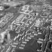
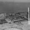
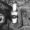
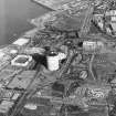
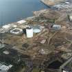
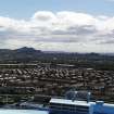
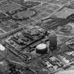
General oblique aerial view.
RCAHMS Aerial Photography
1991
© Crown Copyright: HES

SC 583518
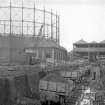
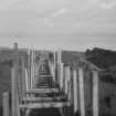
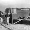
Edinburgh, Granton Gasworks View from W of Gasholder No.1, Pumping and Meter Houses (centre) and Railway under construction, No. 1 and 2 Purifier Houses in background
© RCAHMS

DP 061388
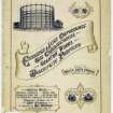
Commemorative cover illustration for Granton Works with gasholder and scroll.
1903
© RCAHMS

DP 074356
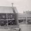
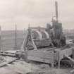
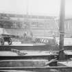
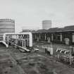
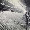
View of machinery during the construction of Granton Gas Works. Titled: 'Portable Engine, Stone Crusher and Concrete Mixer. 11th April 1900'.
Scottish Gas
11/4/1900
© RCAHMS

DP 074357
View of machinery, Granton Gas Works Titled: 'Mortar Mill for mixing cement for Retort House and Coal Store. 11th April 1900'.
Scottish Gas
11/4/1900
© RCAHMS

DP 102660
View of plant house during the constructions of Granton Gasworks in 1902. PHOTOGRAPH ALBUMS NO.207: SCOTTISH GAS COLLECTION, GRANTON GASWORKS ALBUMS
8/4/1902

SC 1437816
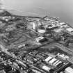
Granton Gas Works Edinburgh, Midlothian, Scotland. Oblique aerial photograph taken facing North/East. This image was marked by AeroPictorial Ltd for photo editing.
Aero Pictorial
23/6/1949
© Courtesy of HES (Aero Pictorial Collection)

SC 1491989
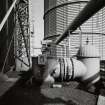
Edinburgh, Granton Gasworks, Rateau Booster House, interior View from NW showing rear view of motors of Rateau Turbo Booster nos 3 and 4 built by Bryan Donkin Co Ltd of Chesterfield. The ducts bring fresh air from outside to cool the motors
Records of the Royal Commission on the Ancient and Historical Monuments of Scotland (RCAHMS), Edinbu
6/10/1998
© Crown Copyright: HES

SC 1505003
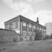
Edinburgh, Granton Gasworks, Coal Store and Plant House No.2 General view of truncated former Coal Store Building from SW showing former Plant House No.2 at S end of range. Now used as general storage area
Records of the Royal Commission on the Ancient and Historical Monuments of Scotland (RCAHMS), Edinbu
6/10/1998
© Crown Copyright: HES

SC 1505006
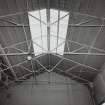
Edinburgh, Granton Gasworks, Coal Store Building, interior View of former Coal Store Building from N showing modern roof truss structure, right hand bay, of 3 bay building. Now used as a general store
Records of the Royal Commission on the Ancient and Historical Monuments of Scotland (RCAHMS), Edinbu
6/10/1998
© Crown Copyright: HES

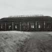
SC 1505010
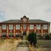
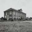
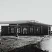
Edinburgh, Granton Gasworks, Station Building General view of rear of Station Building from SE showing no.3 gasholder on right, original boundary wall and former railway sidings area in foreground
Records of the Royal Commission on the Ancient and Historical Monuments of Scotland (RCAHMS), Edinbu
6/10/1998
© Crown Copyright: HES

SC 1505036
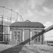
Edinburgh, Granton Gasworks, Meter House View from W, gasholder no.1 (c.1899) behind with common feed leg (left)
Records of the Royal Commission on the Ancient and Historical Monuments of Scotland (RCAHMS), Edinbu
6/10/1998
© Crown Copyright: HES

SC 1505038
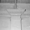
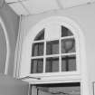
Edinburgh, Granton Gasworks, Meter House, interior Detail of typical pilaster and cornice. This detail is similar to the Pumping Station
Records of the Royal Commission on the Ancient and Historical Monuments of Scotland (RCAHMS), Edinbu
6/10/1998
© Crown Copyright: HES

SC 1532005
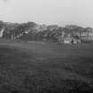
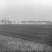
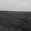
Photograph recording the site of Granton Gasworks, Edinburgh, prior to construction, looking NW towards the buildings in the NW corner of the site.
Scottish Gas
10/1898
© Courtesy of HES (Granton Gasworks Collection)

SC 1573572
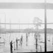
Edinburgh, Granton Gasworks, Waterless gasholder under construction "Bottom Plate in position looking S", Purifier Houses and Meter House in background
Scottish Gas
3/9/1929
© Courtesy of HES (Scottish Gas Collection)

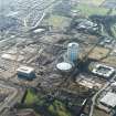
SC 1678783
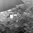
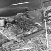
Oblique aerial view centred on the gasworks with the country house adjacent, taken from the ESE.
RCAHMS Aerial Photography
12/3/2003
© Crown Copyright: HES

SC 1678788
Oblique aerial view centred on the gasworks with the country house adjacent, taken from the SW.
RCAHMS Aerial Photography
12/3/2003
© Crown Copyright: HES

SC 1678805
Oblique aerial view centred on the gasworks with the country house adjacent, taken from the WNW.
RCAHMS Aerial Photography
12/3/2003
© Crown Copyright: HES

SC 1678809
Oblique aerial view centred on the gasworks with the country house adjacent, taken from the S.
RCAHMS Aerial Photography
12/3/2003
© Crown Copyright: HES

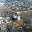
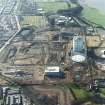
SC 1679411
Oblique aerial view centred on the gasworks, taken from the ESE.
RCAHMS Aerial Photography
3/11/2000
© Crown Copyright: HES

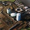
SC 1679423
Oblique aerial view centred on the gasworks, taken from the WSW.
RCAHMS Aerial Photography
3/11/2000
© Crown Copyright: HES

DP 345624
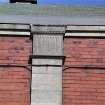
Standing building survey, Detail view of coal store block exterior, Granton Gasworks, Edinburgh
Records of AOC Archaeology Group, archaeologists, Loanhead, Midlothian, Scotland
5/2001
© AOC Archaeology Group

DP 345633
Standing building survey, Detail view of coal store block exterior, Granton Gasworks, Edinburgh
Records of AOC Archaeology Group, archaeologists, Loanhead, Midlothian, Scotland
5/2001
© AOC Archaeology Group

DP 345642
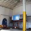
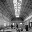
Standing building survey, General interior view, Granton Gasworks, Edinburgh
Records of AOC Archaeology Group, archaeologists, Loanhead, Midlothian, Scotland
5/2001
© AOC Archaeology Group

DP 345676
Standing building survey, Detail view of coal store block exterior, Granton Gasworks, Edinburgh
Records of AOC Archaeology Group, archaeologists, Loanhead, Midlothian, Scotland
5/2001
© AOC Archaeology Group

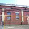
DP 345678
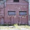
Standing building survey, General view of coal store block exterior, Granton Gasworks, Edinburgh
Records of AOC Archaeology Group, archaeologists, Loanhead, Midlothian, Scotland
5/2001
© AOC Archaeology Group

DP 345729
Standing building survey, General interior view, Granton Gasworks, Edinburgh
Records of AOC Archaeology Group, archaeologists, Loanhead, Midlothian, Scotland
5/2001
© AOC Archaeology Group

DP 345735
Standing building survey, General interior view, Granton Gasworks, Edinburgh
Records of AOC Archaeology Group, archaeologists, Loanhead, Midlothian, Scotland
5/2001
© AOC Archaeology Group

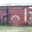
DP 345788
Standing building survey, Detail view of workshop exterior, Granton Gasworks, Edinburgh
Records of AOC Archaeology Group, archaeologists, Loanhead, Midlothian, Scotland
6/2001
© AOC Archaeology Group

DP 345812
Standing building survey, Detail view of workshop exterior, Granton Gasworks, Edinburgh
Records of AOC Archaeology Group, archaeologists, Loanhead, Midlothian, Scotland
6/2001
© AOC Archaeology Group

DP 345814
Standing building survey, Detail view of workshop exterior, Granton Gasworks, Edinburgh
Records of AOC Archaeology Group, archaeologists, Loanhead, Midlothian, Scotland
6/2001
© AOC Archaeology Group

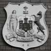
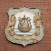
SC 2661606
Edinburgh, Granton Gasworks, Rateau Booster House Detail of cast iron plaque to left of main door showing the Edinburgh City coat of arms bearing the legend 'Nisi Dominus Frustra' (translation 'Without the Lord, all is in vain')
Records of the Royal Commission on the Ancient and Historical Monuments of Scotland (RCAHMS), Edinbu
6/10/1998
© Crown Copyright: HES

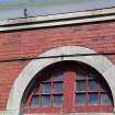
SC 2661634
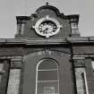
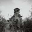
Edinburgh, Granton Gasworks, Station Building Detail of Clock Tower on Station Building from W. This has since suffered storm damage (January 1999)
Records of the Royal Commission on the Ancient and Historical Monuments of Scotland (RCAHMS), Edinbu
6/10/1998
© Crown Copyright: HES

SC 2661645
Edinburgh, Granton Gasworks, Engine shed/ workshops, interior Detail of E wall roof support corbel and projecting bolts which carried (now removed) brackets for overhead belt shaft drive
Records of the Royal Commission on the Ancient and Historical Monuments of Scotland (RCAHMS), Edinbu
6/10/1998
© Crown Copyright: HES

SC 2661650
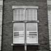
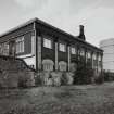
Edinburgh, Granton Gasworks, Pumping Station View of typical window with ventilation grill below
Records of the Royal Commission on the Ancient and Historical Monuments of Scotland (RCAHMS), Edinbu
6/10/1998
© Crown Copyright: HES

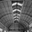
SC 2661659
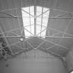
Edinburgh, Granton Gasworks, Meter House, interior View from E showing pavilion roof structure and unmaintained clerestory glazing (building dis-used on date of survey). Two Connersville Meters by WC Holmes and Co. of Huddersfield (1949) are visible in middle background
Records of the Royal Commission on the Ancient and Historical Monuments of Scotland (RCAHMS), Edinbu
6/10/1998
© Crown Copyright: HES

SC 2661669
Edinburgh, Granton Gasworks, Gasholder No. 1 View from W of one of two original inlet or outlet valves of gasholder no.1 (c.1899 - whether inlet of outlet could not be ascertained on date of survey). On the date of survey, this functioned as the working leg of no.1 holder which allows gas both in and out. Gas distribution, on the date of survey, was controlled remotely from Newcastle
Records of the Royal Commission on the Ancient and Historical Monuments of Scotland (RCAHMS), Edinbu
6/10/1998
© Crown Copyright: HES

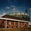
SC 436657
Edinburgh, Granton Gasworks, Meter House, interior View from E showing pavilion roof structure and unmaintained clerestory glazing (building dis-used on date of survey). Two Connersville Meters by WC Holmes and Co. of Huddersfield (1949) are visible in middle background
6/10/1998
© RCAHMS

SC 436658
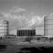
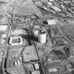
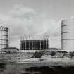
North area of Granton Gasworks, Edinburgh. General view from S of gasholders 2, 1 and 3 with Meter House (left) and Pumping Station (right). The red brick structure (right) is the remains of the redundant cooling water pumps. This has lost its wooden cooling tower. Left and right structures since demolished.
6/10/1998
© RCAHMS

SC 582933
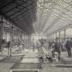
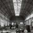
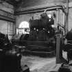
Edinburgh, 336 West Granton Road, Granton Gasworks, Interior View showing Browett and Lindley Compound generating set
Papers of Professor John R Hume, economic and industrial historian, Glasgow, Scotland
1981
© HES. Reproduced courtesy of J R Hume

SC 583520
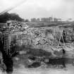
Edinburgh, Granton Gasworks No.1 and 2 Purifier Houses under construction
© RCAHMS

DP 052686
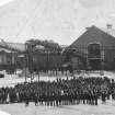
Group or possible family portrait during the construction of the Granton Gasworks.
Scottish Gas
12/9/1901
© RCAHMS

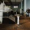
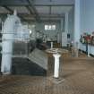
SC 1504996
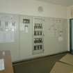
Edinburgh, Granton Gasworks, Rateau Booster House with Control Room over, interior View of control room panel
Records of the Royal Commission on the Ancient and Historical Monuments of Scotland (RCAHMS), Edinbu
6/10/1998
© Crown Copyright: HES

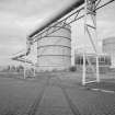
SC 1505000
Edinburgh, Granton Gasworks, Jet Booster compound General elevated view from W showing gas holders, former Coal Store building and Jet Booster compound. The direct feeds are on the right, feeding the town with pipeline gas. The unit in the right foreground is the Ferranti 'skid' or portable unit supplying the pipeline to Ferranti's at Crewe Toll
Records of the Royal Commission on the Ancient and Historical Monuments of Scotland (RCAHMS), Edinbu
6/10/1998
© Crown Copyright: HES

SC 1505015
Edinburgh, Granton Gasworks, Station Building, interior View of circular stairwell leading from platform level to footbridge access on first floor (footbridge now removed and access blocked)
Records of the Royal Commission on the Ancient and Historical Monuments of Scotland (RCAHMS), Edinbu
6/10/1998
© Crown Copyright: HES

SC 1505029
Edinburgh, Granton Gasworks, Pumping Station View of doorway from N
Records of the Royal Commission on the Ancient and Historical Monuments of Scotland (RCAHMS), Edinbu
6/10/1998
© Crown Copyright: HES

SC 1505040
Edinburgh, Granton Gasworks, Meter House, interior View from NW showing original wood dado panelling in SE corner. This detail is similar to the Pumping Station
Records of the Royal Commission on the Ancient and Historical Monuments of Scotland (RCAHMS), Edinbu
6/10/1998
© Crown Copyright: HES

SC 1505051
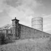
Edinburgh, Granton Gasworks, Boundary Wall View from SE of original E boundary wall incorporating the engine shed and mechanics workshop. Gasholder no.3 is in the background
Records of the Royal Commission on the Ancient and Historical Monuments of Scotland (RCAHMS), Edinbu
6/10/1998
© Crown Copyright: HES

SC 1531994
Photograph recording the site of Granton Gasworks, Edinburgh, prior to construction, looking NE from the SW corner of the site.
Scottish Gas
10/1898
© Courtesy of HES (Granton Gasworks Collection)

SC 1531995
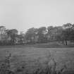
Photograph recording the site of Granton Gasworks, Edinburgh, prior to construction, looking N along the E side of the site.
Scottish Gas
10/1898
© Courtesy of HES (Granton Gasworks Collection)

SC 1531998
Photograph recording the site of Granton Gasworks, Edinburgh, prior to construction, showing the SE of the site with the road bridge over the Caledonian Railway Granton Branch in the left background.
Scottish Gas
10/1898
© Courtesy of HES (Granton Gasworks Collection)

SC 1531999
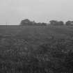
Photograph recording the site of Granton Gasworks, Edinburgh, prior to construction, looking SW over the S part of the site towards Granton Mains Farm.
Scottish Gas
10/1898
© Courtesy of HES (Granton Gasworks Collection)

SC 1532007
Photograph recording the site of Granton Gasworks, Edinburgh, prior to construction, looking E to W across the site.
Scottish Gas
10/1898
© Courtesy of HES (Granton Gasworks Collection)

SC 1532029
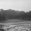
Photograph of the coast west of Granton Gasworks, Edinburgh, prior to the construction of the gasworks. The top of a house, possibly Craigroyston House, just appears above the trees in the background.
Scottish Gas
10/1898
© Courtesy of HES (Granton Gasworks Collection)

SC 1532035
Photograph recording the site of Granton Gasworks, Edinburgh, at the start of construction, looking N across the NW corner of the site.
Scottish Gas
7/3/1899
© Courtesy of HES (Granton Gasworks Collection)

SC 1573573
Edinburgh, Granton Gasworks Waterless gasholder under construction "Lowering the Bottom Plate"
Scottish Gas
8/1929
© Courtesy of HES (Scottish Gas Collection)

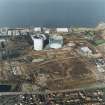
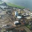
SC 1677368
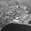
Oblique aerial view centred on the office and works with the harbour, industrial estate and gas works adjacent, taken from the E.
RCAHMS Aerial Photography
2/5/2001
© Crown Copyright: HES

SC 1678786
Oblique aerial view centred on the gasworks with the country house adjacent, taken from the W.
RCAHMS Aerial Photography
12/3/2003
© Crown Copyright: HES

SC 1678787
Oblique aerial view centred on the gasworks with the country house adjacent, taken from the WSW.
RCAHMS Aerial Photography
12/3/2003
© Crown Copyright: HES

SC 1678798
Oblique aerial view centred on the gasworks, taken from the ESE.
RCAHMS Aerial Photography
12/3/2003
© Crown Copyright: HES

SC 1678799
Oblique aerial view centred on the gasworks, taken from the E.
RCAHMS Aerial Photography
12/3/2003
© Crown Copyright: HES

SC 1678801
Oblique aerial view centred on the gasworks with the country house adjacent, taken from the NE.
RCAHMS Aerial Photography
12/3/2003
© Crown Copyright: HES

SC 1678807
Oblique aerial view centred on the gasworks with the country house adjacent, taken from the SW.
RCAHMS Aerial Photography
12/3/2003
© Crown Copyright: HES

DP 345662
Standing building survey, General view of coal store block exterior, Granton Gasworks, Edinburgh
Records of AOC Archaeology Group, archaeologists, Loanhead, Midlothian, Scotland
5/2001
© AOC Archaeology Group

DP 345696
Standing building survey, General view of coal store block exterior, Granton Gasworks, Edinburgh
Records of AOC Archaeology Group, archaeologists, Loanhead, Midlothian, Scotland
5/2001
© AOC Archaeology Group

DP 345740
Standing building survey, General view of coal store block exterior, Granton Gasworks, Edinburgh
Records of AOC Archaeology Group, archaeologists, Loanhead, Midlothian, Scotland
5/2001
© AOC Archaeology Group

DP 345778
Standing building survey, General view from roof showing Arthur's Seat and Edinburgh Castle, Granton Gasworks, Edinburgh
Records of AOC Archaeology Group, archaeologists, Loanhead, Midlothian, Scotland
5/2001
© AOC Archaeology Group

SC 2661610
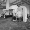
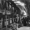
Edinburgh, Granton Gasworks, Rateau Booster House, interior View from NW showing Rateau Boosters 1 - 4. The intrinsically safe swithgear is on the right. The Rateau Boosters are used for filling the gasholders and for the distribution of gas throughout Edinburgh
Records of the Royal Commission on the Ancient and Historical Monuments of Scotland (RCAHMS), Edinbu
6/10/1998
© Crown Copyright: HES

SC 2661612
Edinburgh, Granton Gasworks, Jet Booster compound General elevated view from W showing gas holders, former Coal Store building and Jet Booster compound. The direct feeds are on the right, feeding the town with pipeline gas. The unit in the right foreground is the Ferranti 'skid' or portable unit supplying the pipeline to Ferranti's at Crewe Toll
Records of the Royal Commission on the Ancient and Historical Monuments of Scotland (RCAHMS), Edinbu
6/10/1998
© Crown Copyright: HES

SC 2661619
Edinburgh, Granton Gasworks, Coal Store and Plant House No.2 General view of truncated former Coal Store Building from SW showing former Plant House No.2 at S end of range. Now used as general storage area
Records of the Royal Commission on the Ancient and Historical Monuments of Scotland (RCAHMS), Edinbu
6/10/1998
© Crown Copyright: HES

SC 2661623
Edinburgh, Granton Gasworks, Coal Store Building, interior View of former Coal Store Building from N showing modern roof truss structure, right hand bay, of 3 bay building. Now used as a general store
Records of the Royal Commission on the Ancient and Historical Monuments of Scotland (RCAHMS), Edinbu
6/10/1998
© Crown Copyright: HES

SC 2661627
Edinburgh, Granton Gasworks, Station Building General view from W showing the original gas lamps (moved from elsewhere) and the now blocked footbridge access to the first floor. This has been blocked and a round headed window inserted. The clock suffered storm damage in early 1999
Records of the Royal Commission on the Ancient and Historical Monuments of Scotland (RCAHMS), Edinbu
6/10/1998
© Crown Copyright: HES

SC 2661628
Edinburgh, Granton Gasworks, Station Building General view of rear of Station Building from SE showing no.3 gasholder on right, original boundary wall and former railway sidings area in foreground
Records of the Royal Commission on the Ancient and Historical Monuments of Scotland (RCAHMS), Edinbu
6/10/1998
© Crown Copyright: HES

SC 2661629
Edinburgh, Granton Gasworks, Station Building General view from N looking towards the W frontage of Station Building across former railway sidings. Note the platform, original boundary wall and former gas lamp posts (not original site). The covered platform area was infilled and offices built. It was at that time that the overbridge was removed and the first floor access was blocked. The clock above the blocked access suffered storm damage in early 1999
Records of the Royal Commission on the Ancient and Historical Monuments of Scotland (RCAHMS), Edinbu
6/10/1998
© Crown Copyright: HES

SC 2661646
Edinburgh, Granton Gasworks, Pumping Station General view from N. Supports for gasholder no.1 on extreme right. The overhead pipe is the standby leg for gasholder no. 3. The filling leg is visible in the background
Records of the Royal Commission on the Ancient and Historical Monuments of Scotland (RCAHMS), Edinbu
6/10/1998
© Crown Copyright: HES

SC 2661651
Edinburgh, Granton Gasworks, Pumping Station, interior View of pavilion roof structure with original clerestory glazing removed
Records of the Royal Commission on the Ancient and Historical Monuments of Scotland (RCAHMS), Edinbu
6/10/1998
© Crown Copyright: HES

SC 2661654
Edinburgh, Granton Gasworks, Meter House General view from N with standby leg no.1 (left) and common feed on left and right for the other holders (gasholder nos. 2 and 3)
Records of the Royal Commission on the Ancient and Historical Monuments of Scotland (RCAHMS), Edinbu
6/10/1998
© Crown Copyright: HES

SC 2661656
Edinburgh, Granton Gasworks, Meter House General view from SW with gasholders nos. 1 (c.1899) and 3 (c.1969) behind. The pipes are the common leg gas flow and return to gasholders installed in c.1969
Records of the Royal Commission on the Ancient and Historical Monuments of Scotland (RCAHMS), Edinbu
6/10/1998
© Crown Copyright: HES

SC 2661666
Edinburgh, Granton Gasworks, N area, general view General view from S of gasholders 2, 1 and 3 with Meter House (left) and Pumping Station (right). The red brick structure (right) is the remains of the redundant cooling water pumps. This has lost its wooden cooling tower
Records of the Royal Commission on the Ancient and Historical Monuments of Scotland (RCAHMS), Edinbu
6/10/1998
© Crown Copyright: HES

SC 2661675
Edinburgh, Granton Gasworks, Boundary Wall View from SE of original E boundary wall incorporating the engine shed and mechanics workshop. Gasholder no.3 is in the background
Records of the Royal Commission on the Ancient and Historical Monuments of Scotland (RCAHMS), Edinbu
6/10/1998
© Crown Copyright: HES

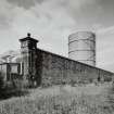
SC 2661677
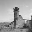
Edinburgh, Granton Gasworks, Boundary Wall View of boundary wall turret, NE corner of site from SW
Records of the Royal Commission on the Ancient and Historical Monuments of Scotland (RCAHMS), Edinbu
6/10/1998
© Crown Copyright: HES

SC 583546
Edinburgh, Granton Gasworks. Copy of original photograph held at Granton Gasworks showing opening ceremony.
© RCAHMS

DP 052692
View of station buildings under construction. PHOTOGRAPH ALBUMS NO.207: SCOTTISH GAS COLLECTION: GRANTON GASWORKS ALBUMS
Scottish Gas
31/7/1901
© RCAHMS

DP 052703
View of quarry, Granton Gas Works. Page 29: 'New Quarry from South West Corner 11th September 1900'.
Scottish Gas
10/7/1899
© RCAHMS

DP 102661
View of retort house during the construction of Granton Gasworks. PHOTOGRAPH ALBUMS NO.207: SCOTTISH GAS COLLECTION, GRANTON GASWORKS ALBUMS
Scottish Gas
30/5/1906

SC 1438531
Scottish Gas Board, Granton Gas Edinburgh, Midlothian, Scotland. Oblique aerial photograph taken facing North. This image was marked by AeroPictorial Ltd for photo editing.
Aero Pictorial
23/5/1957
© Courtesy of HES (Aero Pictorial Collection)

SC 1438534
Scottish Gas Board, Granton Gas Edinburgh, Midlothian, Scotland. Oblique aerial photograph taken facing South.
Aero Pictorial
23/5/1957
© Courtesy of HES (Aero Pictorial Collection)

SC 1491991
Edinburgh, Granton Gasworks, Rateau Booster House Detail of cast iron plaque to right of main door showing the Leith coat of arms with the legend 'Persevere'
Records of the Royal Commission on the Ancient and Historical Monuments of Scotland (RCAHMS), Edinbu
6/10/1998
© Crown Copyright: HES

SC 1504997
Edinburgh, Granton Gasworks, Rateau Booster House, interior View from NW showing Rateau Boosters 1 - 4. The intrinsically safe swithgear is on the right. The Rateau Boosters are used for filling the gasholders and for the distribution of gas throughout Edinburgh
Records of the Royal Commission on the Ancient and Historical Monuments of Scotland (RCAHMS), Edinbu
6/10/1998
© Crown Copyright: HES

SC 1505001
Edinburgh, Granton Gasworks, Jet Booster compound View of jet booster compound (c.1966) and high pressure gas intake pipes. The Jet Boosters keep the holder gas stocks up during peak demand (using a venturi valve)
Records of the Royal Commission on the Ancient and Historical Monuments of Scotland (RCAHMS), Edinbu
6/10/1998
© Crown Copyright: HES

SC 1505009
Edinburgh, Granton Gasworks, Station Building General view from W showing the original gas lamps (moved from elsewhere) and the now blocked footbridge access to the first floor. This has been blocked and a round headed window inserted. The clock suffered storm damage in early 1999
Records of the Royal Commission on the Ancient and Historical Monuments of Scotland (RCAHMS), Edinbu
6/10/1998
© Crown Copyright: HES

SC 1505011
Edinburgh, Granton Gasworks, Station Building General view from N looking towards the W frontage of Station Building across former railway sidings. Note the platform, original boundary wall and former gas lamp posts (not original site). The covered platform area was infilled and offices built. It was at that time that the overbridge was removed and the first floor access was blocked. The clock above the blocked access suffered storm damage in early 1999
Records of the Royal Commission on the Ancient and Historical Monuments of Scotland (RCAHMS), Edinbu
6/10/1998
© Crown Copyright: HES

SC 1505017
Edinburgh, Granton Gasworks, Station Building, interior View light above door to (latterly) the transmission and records office in NW portion of building, ground floor from W
Records of the Royal Commission on the Ancient and Historical Monuments of Scotland (RCAHMS), Edinbu
6/10/1998
© Crown Copyright: HES

SC 1505020
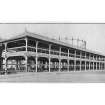
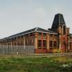
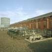
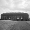
Edinburgh, Granton Gasworks, Engine shed/mechanics workshops General view of 2 by 17 bay engine shed/ mechanics workshops from SW
Records of the Royal Commission on the Ancient and Historical Monuments of Scotland (RCAHMS), Edinbu
6/10/1998
© Crown Copyright: HES

SC 1505021
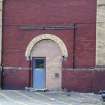
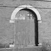
Edinburgh, Granton Gasworks, Engine shed/ mechanics workshop Detail of arched doorway in W frontage
Records of the Royal Commission on the Ancient and Historical Monuments of Scotland (RCAHMS), Edinbu
6/10/1998
© Crown Copyright: HES

SC 1505034
Edinburgh, Granton Gasworks, Meter House General view from N with standby leg no.1 (left) and common feed on left and right for the other holders (gasholder nos. 2 and 3)
Records of the Royal Commission on the Ancient and Historical Monuments of Scotland (RCAHMS), Edinbu
6/10/1998
© Crown Copyright: HES

SC 1505047
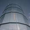
Edinburgh, Granton Gasworks, Gasholder No.3 View of german design M.A.N. waterless gasholder no.3 (c.1969). Stock gauge is visible
Records of the Royal Commission on the Ancient and Historical Monuments of Scotland (RCAHMS), Edinbu
6/10/1998
© Crown Copyright: HES

SC 1505050
Edinburgh, Granton Gasworks, W area of site View of surviving standard gauge railway track on W part of site, Gasholder No.2 and the flow and return legs to the three gasholders from SW
Records of the Royal Commission on the Ancient and Historical Monuments of Scotland (RCAHMS), Edinbu
6/10/1998
© Crown Copyright: HES

SC 1505053
Edinburgh, Granton Gasworks, Boundary Wall View from NW of E boundary wall, turret detail
Records of the Royal Commission on the Ancient and Historical Monuments of Scotland (RCAHMS), Edinbu
6/10/1998
© Crown Copyright: HES

SC 1531996
Photograph recording the site of Granton Gasworks, Edinburgh, prior to construction, looking W along the S boundary of the site. Buildings in the background include cottages near Granton Mains and the lodge at the entrance to Granton House.
Scottish Gas
10/1898
© Courtesy of HES (Granton Gasworks Collection)


First 100 images shown. See the Collections panel (below) for a link to all digital images.
- Council Edinburgh, City Of
- Parish Edinburgh (Edinburgh, City Of)
- Former Region Lothian
- Former District City Of Edinburgh
- Former County Midlothian
Location formerly cited as centred NT 22437 77079.
NT27NW 20.01 NT 22612 76990 Fitting Shop
NT27NW 20.02 NT 22336 76753 Control House
NT27NW 20.03 NT 22428 76839 Store Block
NT27NW 20.04 NT 22638 76845 Railway Station
NT27NW 20.05 NT 22437 77079 Gate Lodge
NT27NW 20.06 NT 22441 77091 No. 1 Gasholder
Gas Works [NAT] (at NT 2213 7688)
Gasholders [NAT] (at NT 2252 7706)
Gasholders [NAT] (at NT 2201 7698)
OS 1:10,000 map, 1987.
RCAHMS REFERENCE
76 photograph albums containing progress photographs of every aspect of architectural and technical construction undertaken by the Company at Granton including the opening ceremony etc 1899-1931.
(Undated) information in NMRS.
NT 2231 7696 Prior to residential redevelopment, linear evaluation trenching in July and August 2002 on two areas within the site of the former Granton Gasworks failed to uncover significant archaeological features or artefacts.
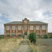
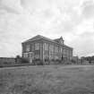
A programme of standing building recording was required as a condition of planning consent on two buildings to the N of the site: the Pump House and Meter House. The two buildings were part of the first major construction of works which began in 1899 and were of a balanced Edwardian design in a red terracotta brick and steel-framed construction. The programme of building recording produced elevation drawings and a written and photographic record prior to their demolition. Access to the interior of these buildings was denied for health and safety reasons. (AOC 3479, AOC 3518)
Archive to be deposited in the NMRS.
Sponsor: Lattice Property Holdings.
Martin Cook and D Sproat (AOC) 2002.
Standing Building Recording (May 2001 - August 2001)
NT 2231 7696 Prior to the redevelopment of Granton Gasworks (NMRS NT27NW 20) a programme of standing building recording and historical research was carried out in May, June and August 2001.
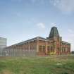
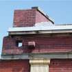
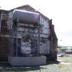
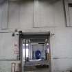
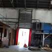
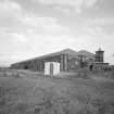
A standing building survey and analysis was carried out at three of the remaining early 20th-century buildings: the coal store block erected between 1898 and 1903; the workshops building erected between 1903 and 1910; and the TRANSCO control house building erected in the 1930s. A section of the stone boundary wall to the NE was also recorded.
The buildings were once part of a large complex of industrial buildings constructed in the early 20th century and designed by Walter Ralph Herring for the Edinburgh & Leith Gas Commissioners' Company. Many of Herring's original buildings on the 106? acre site have already been demolished, hence the programme of building recording aims to be a 'preservation by record' of an incomplete heritage.
Sponsor: Lattice Properties.
D Sproat 2001
Photographic Survey
Photographs taken during the construction of Granton Gasworks showing every technical and architectural aspect of the building. HES holds 76 albums and a set of glass negatives.

