
Edinburgh, West Shore Road, Granton Castle


Castle (Medieval)
Site Name Edinburgh, West Shore Road, Granton Castle
Classification Castle (Medieval)
Alternative Name(s) Royston House; Royston Castle; West Shore Road; Roystoun Castle; Old Granton House
Canmore ID 52042
Site Number NT27NW 2
NGR NT 2258 7727
Datum OSGB36 - NGR
Permalink http://canmore.org.uk/site/52042


- Council Edinburgh, City Of
- Parish Edinburgh (Edinburgh, City Of)
- Former Region Lothian
- Former District City Of Edinburgh
- Former County Midlothian
NT27NW 2 2258 7727.
(NT 2258 7727) Granton Castle (NR) (site of)
OS 1:10,000 map, (1975)
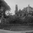
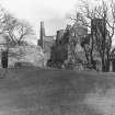
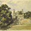
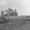
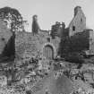
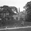
Royston House or Granton Castle was demolished recently. The nucleus of the house was a late 16th century structure built on the L-plan, and which was considerably altered in the 17th century by the extension of a W wing. S and E of the house were quadrangular garden enclosures, while to the N lay the courtyard which contained outbuildings.
RCAHMS 1929.
All traces of this building have been removed, and only a small fragment of the NE corner of the courtyard wall remains at NT 2258 7730.
Visited by OS (J L D) 30 November 1953.
No change to previous field report.
Visited by OS (B S) 26 November 1975.
A trial trench across the site of the 16th century castle (demolished after 1914) showed that all archaeological deposits had been destroyed. 2.55m of modern infill overlay marine alluvial silts.
Sponsor: City of Edinburgh District Council.
M Collard 1992.
(NT 225 772) A desk-based assessment and walkover survey were carried out in September 2002 on the site of a proposed primary school. This showed that Granton Castle and features of its designed landscape lay within the proposed development area, including a B-Listed doocot and a boundary wall (NT27NW 15). The area previously occupied by Granton Castle lies within an area of quarrying. There were no visible traces of the castle, but the doocot and boundary walls are still standing and appear to be in good condition.
Report lodged with Edinburgh SMR and the NMRS.
Sponsor: City of Edinburgh Council.
M Johnson 2003.
NT 225 772 An archaeological watching brief was undertaken in January 2006 during ground-breaking works between Waterfront Broadway and West Shore Road, Granton. A stone culvert was recorded running E-W across the site. No other features of archaeological interest were uncovered.
The archive will be deposited with the NMRS.
Sponsor: Waterfront Edinburgh Ltd
A Curtis 2006.
Demolished c 1920's
From NMRS Architectural Catalogue Slip, RMB
Previous to 1740, when the Duke of Argyll, propriotor of the Barony of Royston purchased the Barony of Granton, Granton Castle was known as Granton House. After 1740 it was renamed Royston House when the previous Royston House became Caroline Park House. Granton Castle was also known as Old Granton House and Royston Caslte.
From NMRS Architecture Catalogue Slip:
RIAS Collection, Henry Kerr's photographs, two old prints of exterior of Granton Castle
Dr Thomas Ross manuscript notes
Field Visit (25 August 1920)
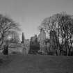
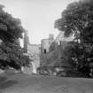
Royston House, or Granton Castle.
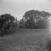
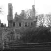
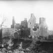
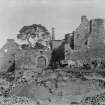
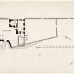
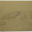
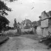
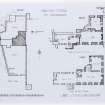
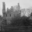
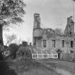
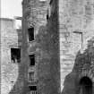
On the rising ground bordering the shore of the Firth of Forth, between the western wharf and the chemical works and immediately south of the shore road, the ruin of Royston House or Granton Castle (Fig. 30) formerly rose above the high walls of its enclosures. Since the following account was prepared the place has been entirely demolished, but for that very reason it has been thought desirable to retain the description, which accordingly deals with the buildings on the accompanying plan as they existed at the date of the visit.
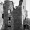
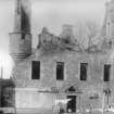
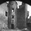
The site commands a wonderful panorama of the Firth, looking over to the wooded uplands of the Fifeshire coast. The buildings are grouped round a courtyard at the north-western angle of the site, where a rocky outcrop of no great height gave a good foundation and a certain amount of protection. The nucleus of the house is a late 16th-century structure built on an L-plan, with a circled stair-tower projecting within the re-entrant angle. The main block, 43 by 26 feet, lies almost east and west; the jamb or wing, 22 by 21 feet, projects northward in continuation of the east gable. The house was considerably altered in the 17th century by throwing out to the west a wing of less width than the main block, but in continuation of the south wall. South and east of the house are quadrangular garden enclosures, while to the north lies the courtyard, which, following the contour of the rock, is irregular in shape, and has been at one time almost totally enclosed by the house and by subsidiary structures. The courtyard is entered from the west by a wide gateway with semicircular head; the jambs and head are wrought with a very bold edge roll and flanking hollow. Above the head there is an empty panel-space within a moulded border. On either side of the gateway are narrow openings in the courtyard wall which appear to be for observation. Externally a small plat or terrace of masonry, which has been described as a mounting block, adjoins the entrance on its north side. The outbuildings were mainly two-storeyed structures. The north-western outbuilding, though it is roofless, is otherwise fairly complete and is altogether a better building than its neighbours. It is oblong on plan, and is rubble-built with polished dressings. The gables are crow-stepped, and the chimney-copes are moulded. The east gable of the adjoining structure on the east has been heightened. It contains a narrow window with a pointed head which has a somewhat ecclesiastical appearance, discounted, however, by its rough construction. Eastward of this, at the north-east angle, but outside the enclosure, are the remains of a small pavilion and terrace fronting the estuary.
The house has been roughcast and is built of rubble, mainly of freestone, with polished rounded or moulded freestone dressings. In height there were three storeys and a garret. The gables are crow-stepped; from the eastern and south-western angles circled turrets project on continuous corbelling of four members, and, being roofed, provided little circular chambers opening off the third floor apartment. The loops for musketry in the turret walls are the only defensive features on the building. The arrises at the original voids were merely rounded off, and sometimes, where later and larger windows are contrived, this treatment is adhered to, but in other later windows a richer effect is obtained by mouldings. This is particularly noticeable in the stair-turret, where the original entrance at ground level and the windows at first- and second-floor levels have elaborately moulded architraves, while the two tiers of windows between these and the eaves course are simply rounded.
The mouldings generally are of the transition type, in which Gothic and Renaissance contours are combined.
The entrance is in the stair-tower; it has a boldly wrought architrave, circled at the upper angles, and surmounted by a little moulded cornice, above which is an empty panel-space with a moulded border. In the north gable oft he wing a second entrance has been inserted, and opens into a vaulted cellar which occupies the northern 12 feet of the wing, and is the only vaulted portion of the nucleus.
The wheel-stair was altered at a later period to the scale-and-platt type; it ascended from ground- to third-floor level. The ground floor of the earlier portion contained originally only two apartments, one in the wing, the other in the main block, and this arrangement was repeated on the first floor. The heavy west gable was built to contain the kitchen fireplace and flue, but, on the formation of a new kitchen within the addition, the flue and fireplace were done away with.
The addition is a two-storeyed oblong block, which contains on the ground floor a vaulted kitchen furnished with a large fireplace, oven, and sink in the west gable. Above the kitchen are two public rooms, reached from the kitchen by a new forestair on the south. The former kitchen was then improved by the formation of larger windows and the provision of a garden door. This is a typically Renaissance feature, with a heavily moulded architrave shouldered at the head and with moulded horizontal and raking cornices. The centre portion of the tympanum, which was most probably inscribed, is missing. On the first floor the Hall was thrown open to the new apartments, and the south windows were enlarged and symmetrically disposed. At this level the old west gable contains a mural closet provided with a fireplace, while at the north-east angle of the north wing there is a garderobe with window and lamp recess, but no flue. The upper floors are inaccessible.
RCAHMS 1929, visited 25 August 1920.
Watching Brief (6 December 2017 - 31 January 2018)
An archaeological watching brief was carried out at land 120m south of 20 West Shore Road, Granton, Edinburgh during ground-works for the construction of 11 temporary nest houses and a temporary social hub. The development area encompasses the site of the 16th century Granton Castle, which was demolished in the late 1920s and the underlying rock on which it was situated quarried away. The watching brief identified a fragment of wall which appears to relate to a curving feature depicted on the 1914 Ordnance Survey map. There were no features, artefacts or deposits of archaeological significance identified.
Information from Stuart Mitchell and Magnus Kirby (CFA Archaeology Ltd) April 2018. OASIS ID: cfaarcha1-315143
Note (19 February 2018)
For associated site records, see:
Granton Castle, Dovecot and Boundary Wall NT27NW 15, Canmore ID 52037
Caroline Park House, Walled Garden NT27NW 3.02, Canmore ID 236077

