 |
On-line Digital Images |
DP 149193 |
Records of the Royal Commission on the Ancient and Historical Monuments of Scotland (RCAHMS), Edinbu |
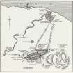
Map of 'Medieval Edinburgh, Canongate and Leith'. |
1951 |
Item Level |
|
 |
On-line Digital Images |
DP 168174 |
Records of the Royal Commission on the Ancient and Historical Monuments of Scotland (RCAHMS), Edinbu |
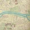
Extract from the 1:500 scale Ordnance Survey map of Edinburgh and its Environs, sheet 12 (1853) annotated with the positions of the medieval bridge over the Water of Leith (NT27NE 7) and St. Ninian's bridge chapel (NT27SE 8.00) at the N end of the bridge. |
9/1853 |
Item Level |
|
 |
On-line Digital Images |
SC 2442770 |
Records of the Ordnance Survey, Southampton, Hampshire, England |
Edinburgh, Leith, Old Bridge Of Leith, NT27NE 7, Ordnance Survey index card, page number 1, Recto |
1958 |
Item Level |
|


