
Edinburgh, Leith Docks


Dock(S) (Post Medieval)
Site Name Edinburgh, Leith Docks
Classification Dock(S) (Post Medieval)
Alternative Name(s) Leith Harbour; Water Of Leith; Port Of Leith; Firth Of Forth; Outer Forth Estuary
Canmore ID 51975
Site Number NT27NE 57
NGR NT 26770 77370
NGR Description Centred NT 26770 77370
Datum OSGB36 - NGR
Permalink http://canmore.org.uk/site/51975


- Council Edinburgh, City Of
- Parish Edinburgh (Edinburgh, City Of)
- Former Region Lothian
- Former District City Of Edinburgh
- Former County Midlothian
NT27NE 57.00 centred 2677 7737
Location also formerly cited as NT 25 77 to NT 27 76.
For (predecessor) Leith, Shore, Harbour (centred NT 2710 7663), see NT27NE 1566.
NT27NE 57.01 NT 26192 77986 and NT 26178 77984 West Breakwater, Lighthouse [Beacon] and Signal Tower
NT27NE 57.02 NT 26338 78223 East Breakwater, Lighthouse [Beacon]
NT27NE 57.03 NT 26501 77830 New Entrance Lock
NT27NE 57.04 NT 27200 77200 Imperial Dock
NT27NE 57.05 NT 27659 76700 Edinburgh Dock
NT27NE 57.06 NT 26886 76866 Victoria Dock
NT27NE 57.07 NT 2619 7800 to NT 2547 7724 West Breakwater
NT27NE 57.08 NT 2633 7823 to NT 2650 7801 East Breakwater
NT27NE 57.09 NT 2699 7670 East Old Dock, Dock Entrance (watching brief, 1996)
NT27NE 57.10 NT 2650 7750 Western Harbour (Leith Roads)
NT27NE 57.11 NT 27559 76765 Swing Bridge between Albert and Edinburgh Docks
NT27NE 57.12 Cancelled: see NT27NE 126.01
NT27NE 57.13 NT 27780 76767 Edinburgh Dock, Hydraulic Pumping Station
NT27NE 57.14 NT 26985 76895 Victoria Dock Entrance, Customs Watch House (Watch Office)
NT27NE 57.15 NT 27150 76925 Albert Dock, Workshops
NT27NE 57.16 NT 27050 77030 Albert Dock Basin
NT27NE 57.17 NT 27768 76627 Edinburgh Dock, Dry Dock
NT27NE 57.18 NT 27147 76863 Albert Dock, Prince of Wales Dry Dock
NT27NE 57.19 NT 27134 76935 Albert Dock, Prince of Wales Dry Dock, Hydraulic Power Station
NT27NE 57.20 NT 27600 76930 Cancelled: see NT27NE 57.23.
NT27NE 57.21 NT 27550 76710 Edinburgh Dock, Warehouse
NT27NE 57.22 NT 27840 76440 Edinburgh Dock, Transit Shed
NT27NE 57.23 NT 27585 76902 Imperial Dock, Grain Elevator
NT27NE 57.24 NT 27720 76639 Edinburgh Dry Dock, Pumping House
NT27NE 57.25 NT 27227 76782 Tower Place, Harbour and Docks Office (Forth Ports Authority headquarters)
NT27NE 57.26 NT 27148 76863 Albert Dock, Alexandra Dry Dock
NT27NE 57.27 NT 2717 7677 Tower Place, North of Scotland, Orkney and Shetland Steam Navigation Co, Offices
NT27NE 57.28 unlocated Power Station
NT27NE 57.29 NT 27010 76720 East Old Dock, Warehouse
NT27NE 57.30 NT 27025 76520 1-31 Commercial Wharf, The Cooperage (No. 9 Bond, Ronaldson's Wharf)
NT27NE 57.31 unlocated Store
NT27NE 57.32 NT 26590 76808 West Old Dock
NT27NE 57.33 NT 26987 76693 East Old Dock, Rennie's Entrance (Lock, swing bridge and winch)
NT27NE 57.34 NT 27111 76851 Alexandra Dry Dock, Hydraulic Power Station
NT27NE 57.35 NT 26966 76718 East Old Dock, New Customs Office
NT27NE 57.36 NT 2699 7675 East Old Dock, Blue Ships' Building (office)
NT27NE 57.37 NT 2703 7677 East Old Dock, Blue Marine Building (office)
NT27NE 57.38 NT 27377 76861 Albert Dock
NT27NE 57.39 NT 27230 76959 Albert Dock, Crane
NT27NE 57.40 NT 27226 76947 Albert Dock, Hydraulic Capstan
NT27NE 57.41 NT 26859 76721 East Old Dock (including cranes)
NT27NE 57.42 NT 27085 76817 Victoria Swing Bridge
NT27NE 57.43 NT 27006 76679 Old East Dock, Lock Keeper's Lodge (1C Dock Place, Waterfront Wine Bar)
NT27NE 57.44 NT 26477 77944 Harbour Master's Office and Port Entrance Control Tower ('Pagoda')
NT27NE 57.45 NT 26136 77945 to NT 26189 77868 to NT 26434 77874 Dam (Western Harbour)
NT27NE 57.46 NT 26760 77560 and NT 26755 77540 Entrance Basin, Pilot Station and Landing Stage
NT27NE 57.47 NT 2685 7744 Entrance Basin
NT27NE 57.48 NT 26959 76896 Victoria Dock, Lock Gates
NT27NE 57.49 NT 26987 77430 Imperial Dock, Dry Dock
NT27NE 57.50 NT 27243 76989 Albert Dock, Custom House
NT27NE 57.51 NT 26638 76881 West Old Dock, West Dry Dock
NT27NE 57.52 NT 26683 76870 West Old Dock, East Dry Dock
NT27NE 57.53 NT 27160 76960 Albert Dock, Old Entrance Lock
NT27NE 57.54 NT 26970 77350 Imperial Dock, Old Entrance Lock
NT27NE 57.55 NT 279 769 Eastern Embankment (East Sands of Leith)
NT27NE 57.56 NT 27525 76860 Albert Dock, (Transit) Shed at North-East corner
NT27NE 57.57 NT 27262 77017 Swing bridge between Albert Dock and Imperial Dock
NT27NE 57.58 NT 27180 76955 Swing bridge between Albert Dock and Albert Dock Basin
NT27NE 57.59 NT 27063 76854 Victoria Bridge
NT27NE 57.60 NT 27399 76745 Albert Dock, Travelling Cranes
See also
NT27NE 43 NT 26885 77757 Martello Tower (Leith Roads)
NT27NE 89.00 NT 27030 76584 67 Commercial Street, Custom House
NT27NE 117 Centred NT 26016 77051 Caledonia Flour Mills (Chancelot Mill)
NT27NE 121 NT 2699 7650 Sandport Street, Dry Dock (Leith Harbour; Water of Leith)
NT27NE 162 Centred NT 2785 7710 Black Rocks (coast defence) Battery
NT27NE 286 NT 270 765 Public House [apparently unlocated]
NT27NE 290 NT 27078 76550 Bernard Street Bridge (Water of Leith)
NT27NE 542 NT 26968 76652 1-11 Dock Place, Warehouse and Offices
NT27NE 663 NT 27186 76705 1-4 Tower Place, Leith Sailors' Home
NT27NE 831 NT 26948 76432 Tolbooth Wynd, Bridge
NT27NE 846 NT 2732 7656 Constitution Street, Warehouse
NT27NE 861 NT 2686 7678 Victoria Quay, The Scottish Office
NT27NE 1007 NT 2703 7676 East Old Dock, Engineering Works
NT27NE 1424 NT 25786 77120 Mulberry Harbours (construction area)
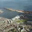
NT27NE 1474 NT 26620 77084 Ocean Terminal (retail centre: HMRY Britannia berthed alongside)
NT27NE 1565 NT 27204 76739 National Dock Labour Board offices (Tower Place)
NT27NE 1567 Centred NT 27400 77300 Imperial Dock, Scottish Agricultural Industries (SAI) Fertiliser Depot
NT27NE 1568 NT c. 268 764 Dry Dock (Robert Dryburgh, 1774)
For (integral) Henry Robb's Shipbuilding Yard (subsequently Robb Caledon and later Multiflex), see:
NT27NE 126.00 centred NT 26600 77000 Shipbuilding Yard
NT27NE 126.01 NT 26724 76990 Paint Shed
For (integral) boatbuilding yard on Water of Leith, see:
NT27NE 1007.00 Centred NT 27020 76750 Boatbuilding Yard
NT27NE 1007. 01 NT 27024 76767 Dry Dock
For (associated) Granton Harbour, see:
NT27NW 28.00 centred NT 23747 77701 Harbour
NT27NW 28.01 NT 23880 77683 to NT 23752 77135 Middle pier and pilot house
NT27NW 28.02 NT 23810 77863 to NT 23148 77489 Western breakwater and esparto wharf
NT27NW 28.03 NT 23934 77888 to NT 24071 77059 Eastern breakwater
NT27NW 28.04 NT 2393 7790 Eastern breakwater, lighthouse (beacon)
NT27NW 28.05 NT 2381 7788 Western breakwater, lighthouse (beacon)
NT27NW 28.06 NT 23829 77658 Middle Pier, lighthouse (beacon)
NT27NW 28.07 NT 2377 7727 Railway Station
NT27NW 28.08 NT 2377 7735 Middle Pier, building
NT27NW 28.09 NT 23803 77566 Stone-built Warehouse
For (adjoining) Newhaven Harbour, see:
NT27NE 76.00 centred NT 25459 77146 Newhaven Harbour
NT27NE 76.01 NT 25545 77188 Fish Market
NT27NE 76.02 NT 25437 77241 Western lighthouse
NT27NE 76.03 NT 25481 77241 Eastern lighthouse
NT27NE 76.04 NT 25409 77150 Breakwater
For survey report (dated 13 April 2005) on the MV Ocean Mist (floating vessel in Leith Docks), see MS/2284.
Leith Docks [NAT] (name centred NT 2663 7740)
OS 1:10,000 map, 1985.
ENGINEERS: John Mylne 1643 - 45
Robert Mylne - reclaimed foreshore 1669
John Rennie 1800 - East & West Docks
NMRS PRINTROOM:
Inglis Photograph Collection, Acc no 1994/90
Two detailed plans of shore/dock area showing sewage plan and proposed overflow.
REFERENCE:
Scottish Record Office:
RHP 9312-9315, 9331-9343 1828-1914 - plans
(Undated) information in NMRS.
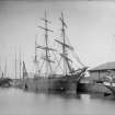
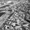
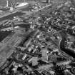
(Location cited as NT 27 77). Leith Harbour. The original harbour was the quayed mouth of the Water of Leith, protected and extended by piers, and this was first modernised by the construction of the East and West Old Docks (1800-6 and 1810-17, engineer John Rennie). These have been filled in, but the entrance gates and two-leaf, cast-iron swing bridge (NT27NE 62) at the entrance to the East Old Dock (NT 270 767) survive.
The Victoria Dock (NT27NE 57.06: 268 768) followed in 1847-51 (engineer J M Rendel). The Prince of Wales Graving Dock (NT27NE 104: 272 269) was added in 1858 and the Albert Dock (NT27NE 63: 274 768) was completed in 1869 (engineers Rendel and Robertson), the first dock in Scotland with hydraulic cranes. The Edinburgh Dock (NT27NE 57.05: 227 767) was built for coal shiment in 1877-81, and the final wet dock, the Imperial Dock (NT27NE 57.04: 273 772) was completed 1896-8. A second large graving dock, the Alexandra, was added beside the Prince of Wales Dock in 1896, engineer Peter Whyte.
Interesting features include a hydraulic crane on Albert Dock, the two hydraulic pumping stations, one of them on Edinburgh Dock (1898) and the other beside the drydocks, an iron bowed-trus swing bridge (NT27NE 61) between the two sides of the harbour, and a mobile hydraulic crane (Cowans Sheldon, 1903) at the W end of Victoria Dock.
Along the S side of the Old Docks is a long 4-storey rubble range of bonded warehouses, with, at the E end, a four-storey and attic, 7-by-12-bay office and warehouse block.
J R Hume 1976.
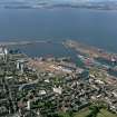
The Forth Ports Authority (FPA) was formed in 1968 to control the ports of Leith (NT27NE 57), Grangemouth (NS98SW 7), Burntisland (NT28NW 30), Methil (NT39NE 11), Kirkcaldy (NT29SE 44) and Granton (NT27NW 28), from headquarters at Leith. Between 1968 and 1983 over £40 million was spent on facilities. In 1982 over 27.5 million tonnes of cargo (of varied types) passed through the Firth of Forth. The FPA also controls the Forth Navigation Service, and is the pilotage authority. The FPA fleet provides towage at Leith, Granton and the Forth ports.
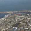
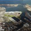
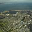
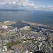
Situated close to Edinburgh, Leith has the water depth, land area and technical facilities not available further North. Its modern lock [NT27NE 57.03] operates on a 24-hour basis, and leads into a large impounded dock complex handling liner services for dry and bulk cargoes, as well as oil-related traffic and cruise vessels; container traffic is developing. Fully loaded vessels of about 25,000 dwt can be readily handled. Mechanised facilities are maintained for the discharge of bulk grain and fertiliser as well as coal export. The FPA has concentrated grain handling at Leith; there are outward shipments of feed and malting barley (including intervention stock). In 1982, the port achieved a turnover of nearly two million tonnes. Principal details are as follows:
Access: 24-hour access by entrance lock 259m long and 31.6m wide between fenders. The depth over the outer sill is 12.3m at MHWS, the water level being maintained constant at all times. The inner (predecessor) entrance [NT27NE 57.17] of the dock system is 18.2m wide.
Imperial Basin [NT27NE 57.19]: common user berth (bunkering facilities). Quayage 200m.
Imperial Dock [NT27NE 57.04]: grain-handling, break-bulk and bulk discharge. Water area 8ha, quayage 1100m, floor area of transit sheds 13, 139 sq. m. Three travelling grain elevators are provided.
Albert Dock [NT27NE 57.20]: container and R-Ro berths. Water area 4.5ha, quayage 677m, floor area of transit sheds 9,824 sq. m. Container compound, break bulk sheds, and road and rail access.
Victoria Dock [NT27NE 57.06]: water area 2ha, quayage 558m, road access.
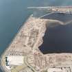
Western Harbour [NT27NE 57.10]: water area 68ha, quayage 296m, road access.
Nos. 8 and 10 berths harbour: quayage 305m, floor area of transit sheds 2313 sq. m.
No. 6 berth harbour: Ro-Ro berth. Quayage 149m, floor area of transit sheds 1404 sq. m.
Imperial dry dock [NT27NE 57.21]: 167.6 x 21.3 x 7.3m.
Alexandra dry dock [NT27NE 57.22]: 100.6 x 14,5 x 5.6m.
Edinburgh dry dock [NT27NE 57.16] (privately owned): 91.4 x 12.2 x 5.7m.
Imperial grain warehouse: 55,880t.
Western Harbour grain warehouse(privately owned): 53,848t.
Bulk cargoes of various types are handled at Imperial Dock [NT27NE 57.04], where the port's unique and sophisticated Siwertell unit allows dust-free discharge of bulk phosphates and potash at a rate of 300t per hour. The fully automatic coal coal-handling plant on the N side of the Edinburgh dock NT27NE 57.05 can load vessels of to 7,200 dwt at rates of up to 3,000t per hour. Grain handling can been concentrated at Imperial Dock, where Leith has the only public grain elevator on the East coast of Scotland; three mobile suction towers discharge vessels at a rate of over 600t per hour. Dust extraction and pelletisation plants have been added to the storage facilities.
General cargoes handled include fruit and vegetables, and forest products. Cruise liners regularly occupy the specialist berth in the Western Harbour, where there is a customs clearance hall. The Western Harbour is also the base for pipelaying vessels and associated coating plants. Offshore tugs and supply vessels are repaired at maintenance facilities within the port.
Total cargo handled in 1982 was 1,948,996t (1,048,640t inwards, and 990,356t outwards).
(Illustrative map and photographs: table of principal tenant companies).
[Forth Ports Authority] 1983.
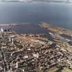
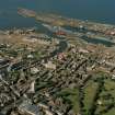
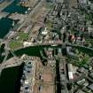
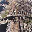
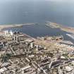
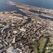
The harbour at Leith is a large commercial port with a series of docks, dry docks, cranes, depots and stores. It is well maintained and the Victorian developments are still extant. Victoria Dock lies in front of the new Scottish Office and is now out of use as a commercial dock.
Site recorded by GUARD during the Coastal Assessment Survey for Historic Scotland, 'The Firth of Forth from Dunbar to the Coast of Fife' 23rd February 1996.
Publication Account (1951)
223. Leith: its Port and Streets.
The original harbour of the seaport mentioned in the 12th century Great Charter of Holyrood was simply the lower reach of the Water of Leith, and it did not extend farther down-stream than Broad Wynd. The docks and warehouses that now exist between this former limit and the foreshore have all come into being in the last two centuries, and the street on the E. bank of the stream is still known as "The Shore." Previous to the time of its destruction at the hands of the English in 1547 Leith, like other Scottish seaports, was a very small place. This is clearly shown by the extent of the fortifications thrown up in the following year by Monsieur D'Esse, commander of the French troops supporting the Regent, Queen Marie de Guise-Lorraine, which actually enclosed the whole area of the town. This system, which was octagonal in shape, straddled the mouth of the river, a timber bridge placing the two banks in communication. The works consisted of a rampart and ditch, strengthened at the corners by eight projecting bastions, two of which, built of stone and situated respectively at the Sandport in North Leith and at the W. end of the present Bernard Street* in South Leith, guarded the approach to the harbour. From the second of these, which was known as Ramsay's Mount, the rampart trended eastwards, parallel with Bernard Street, to a bastion situated where the Corn Exchange Buildings now stand. It then turned S.S.W. and followed the line of Constitution Street as far as a fourth bastion, placed at the junction with Coatfield Lane. From this point it ran towards a fifth bastion at the top of the Kirkgate. The position of the sixth bastion is uncertain. The seventh stood on the W. bank of the river. The eighth appears to have stood where the Citadel (No. 230) rose a century later. In the rampart were seven gates or" ports," that of St. Anthony, situated at the S. end of the Kirkgate, being the principal entry on the landward side. The scanty remains of two counterworks are noted under No. 247.
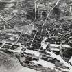
Notwithstanding the facts that the Queen-Regent interested herself in Leith and occupied a house there and that several members of the Court followed her example, the port still appears as very small in comparison with Edinburgh in a contemporary drawing of the siege of the capital in1573 (Fig. 61). North Leith, for instance, on the left bank of the stream, is merely a village on the water-front, while South Leith, on the opposite bank, is shown as a little town built round two main cross-streets. The two communities had been united by a bridge as early as 1439, the name Old Bridgend, which attaches to the junction of Coalhill and Sheriffbrae, indicating the position of one end. The same drawing shows the fortifications of 1548 and 1581 still enclosing the town, as they continued to do for the better part of two centuries after the date at which it was made.
In 1650 Sir David Leslie, commander of the Scottish forces that were opposing Cromwell, threw up a strong earthen breastwork between the capital and its port. This became the path known as the Walk, and ultimately developed into the principal means of communication between the two towns. It is now a street, Leith Walk, which traverses a densely built-up area.
For one reason and another** the growth of Leith was long retarded, and at the end of the reign of George I. the seaport covered less ground than the S. part of the burgh of Edinburgh. Within a century, however, it expanded greatly as a result of improvements made to the harbour; and the rate of expansion increased further after 1832, when the passing of the Reform Bill removed many of the disabilities under which the port had previously laboured.
RCAHMS 1951, visited c.1941
*The position now occupied by Numbers 32-5, The Shore
**E.g., the ravages of the plague of 1645-6,which carried off two-thirds of the population
Publication Account (1985)
Most major dock-systems in Scotland were provided with gates to keep the water-level within as high as possible even at low tide. The original harbour, however, first mentioned in the 12th century Great Charter of Holyrood, simply lined both sides of the Water of Leith along 'The Shore'. It was here that George IV disembarked when he visited Edinburgh in 1822. First these quays were extended and protected by piers, then John Rennie engineered the now filledin East (1800-6) and West (1810-17) Old Docks. The East Dock entrance gate and cast-iron swing-bridge survive (NT 270767). Other docks followed during the second half of the 19th century-Victoria Dock (1847-51), Prince of Wales Graving Dock (1858), Albert Dock (1869), Edinburgh Dock (1877-81: for shipping coal), Imperial Dock (1896-8), Alexandra Graving Dock (1896).
Though much modernised and extended, Leith Docks retain their essentially 19th century layout; they also retain some ofits more particular features. A fine iron swing-bridge joins the two sides of the harbour, across
the river; a hydraulic crane survives at the western end of Albert Dock; warehouses, bonds and office-blocks still line the edge of the Old Docks. Street names betray trading links-e.g. Baltic Street, Elbe Street; whilst the elegant buildings on Commercial Street, Bemard Street and Constitution Street (Custom House, banks, shipping offices, Exchange Building) reflect the prosperity that was once Leith.
Far out towards the new dock gates stands a Martello Tower (NT 268777)-forlorn sentinel and reminder of the Napoleonic Wars, and once isolated on its offshore skerry. And tucked in behind the western breakwater lies the little tidal fishing harbour of Newhaven (NT 254771). Begun in 1812, the L-haped pier, ending in a octagonal lighthouse, dates from 1825; the curved breakwater from 1876-78.
Information from 'Exploring Scotland's Heritage: Lothian and Borders', (1985).
Project (2007)
This project was undertaken to input site information listed in 'Civil engineering heritage: Scotland - Lowlands and Borders' by R Paxton and J Shipway, 2007.
Publication Account (2007)
Leith, the port of Edinburgh, is one of the oldest seaports in the United Kingdom and, from the time of a recorded
mention in ca.1329, for nearly 500 years, consisted of quays adjoining the Water of Leith. From the beginning of the 19th century the port developed as a system of enclosed docks, as follows:
Dock name Date Length and breadth (ft) Depth on sill (ft) Entrance width (ft) ngineer Approx.cost (£)
East 1800–06 750X300 13MHWN 36 J. Rennie 300 000
West 1810–17 750X300 13MHWN 36 J. Rennie
Victoria 1846–52 750X300 20 60 J. Rendel 180 000
Prince
of Wales (dry) 1859 382X70 Disused for many years 60 000
Albert 1862–69 1100X450 22 60 J. Rendel & G. Robertson 350 000
Edinburgh 1874–81 1500X650 22 60 A. M. Rendel & G. Robertson 500 000
Edinburgh
(dry) 1881 300X40 A. M. Rendel & G. Robertson Not known
Alexandra
(dry) 1896 335X48 A. M. Rendel & G. Robertson
Imperial 1897–1904 1900X550 27 70 P. Whyte, Leith Docks 700 000
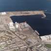
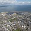
From 1826–29 the eastern pier followed by the western pier and breakwater were built immediately north of the East and West Docks to the design and under the direction of William Chapman, with a timber deck above a rubblework for the former (see cross-section 3-51), at a cost of about £240 000. James Leslie acted as clerk of works. Telford was brought in as costs escalated and reported in 1828 that the order of expenditure was not justified by the trade but his advice was ignored. In 1852 these piers were extended as part of the expansion of the port. By 1896, as a preliminary to building the Imperial Dock, Peter Whyte had designed and directed the provision of a 30 ft high sea wall, 4400 ft long containing almost the whole harbour and of an unusual design.
Large concrete blocks were used on the sea face, the toe blocks for which are 6 ft X 6 ft X 8 ft long. From 1936–42 the western harbour was created with the building of the east and west breakwaters and a wider pier entrance.
In 1969, the year after the Forth Ports Authority was established, the port reached its present form with the completion of the state-of-the-art new entrance lock 850 ft 158long and 110 ft wide which transformed the whole harbour into a deepwater port capable of accommodating ships of 35 ft draught at any high tide. The lock was constructed within an immense cofferdam 1700 ft long. A sealing dam about 1000 ft long was constructed to maintain the level of the impounded water within the harbour. The consulting engineers were Rendel Palmer & Tritton and the main contractor was Edmund Nuttall, Sons & Co.
R Paxton and J Shipway 2007
Reproduced from 'Civil Engineering heritage: Scotland - Lowlands and Borders' with kind permission of Thomas Telford Publishers.

