
Carnethy Hill


Cairn (Prehistoric)
Site Name Carnethy Hill
Classification Cairn (Prehistoric)
Canmore ID 51912
Site Number NT26SW 6
NGR NT 20382 61918
Datum OSGB36 - NGR
Permalink http://canmore.org.uk/site/51912


- Council Midlothian
- Parish Penicuik (Midlothian)
- Former Region Lothian
- Former District Midlothian
- Former County Midlothian
NT26SW 6 2038 6191.
(NT 2038 6191) Cairn (NR)
OS 6" map (1957)
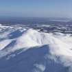
This cairn of bare stones, on the summit of Carnethy Hill, is circular, 70' (21.3m) in diameter and 8' (1.9m) high. Although disturbed superficially in places, the core has apparently not been opened.
RCAHMS 1929; 1988, visited 1913
The cairn measures 23.0m in diameter and 1.9m in height; it has nine small pit shelters and a modern marker cairn on its summit.
Surveyed at 1:10,000.
Visited by OS (MJF) 21 February 1979
Note (1988)
NT26SW 6 2038 6191.
On the summit of Carnethy Hill (576m OD) there is a large cairn of loose stones about 1.9m high. The perimeter of the cairn is now considerably spread, but in 1929 it was circular and measured 21.3m in diameter.
RCAHMS 1988
(RCAHMS 1929, 157, No. 208)

