 |
On-line Digital Images |
DP 106321 |
Scotland's Rural Past |
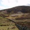
Grain Burn: looking SW, showing Penicuik / Logan estate boundary wall overlying the SE edge of the enclosure |
11/4/2009 |
Item Level |
|
 |
On-line Digital Images |
DP 106322 |
Scotland's Rural Past |
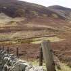
Grain Burn: looking SW towards enclosure (centre) and Grain Hill (rear) |
11/4/2009 |
Item Level |
|
 |
On-line Digital Images |
DP 106323 |
Scotland's Rural Past |
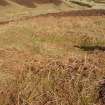
Grain Burn: square structure and lazy beds in NW of enclosure |
11/4/2009 |
Item Level |
|
 |
On-line Digital Images |
SC 1248695 |
Scotland's Rural Past |
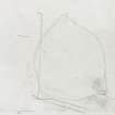
Grain Burn: measured survey drawn at 1:500 by Midlothian Field Group (drawn up by Jane Murray) |
4/1983 |
Item Level |
|
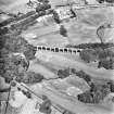 |
On-line Digital Images |
SC 1680738 |
RCAHMS Aerial Photography |
Aerial view. |
1981 |
Item Level |
|
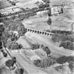 |
On-line Digital Images |
SC 1680739 |
RCAHMS Aerial Photography |
Aerial view. |
1981 |
Item Level |
|
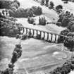 |
On-line Digital Images |
SC 1680740 |
RCAHMS Aerial Photography |
Aerial view. |
1981 |
Item Level |
|
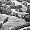 |
On-line Digital Images |
SC 1680741 |
RCAHMS Aerial Photography |
Aerial view. |
1981 |
Item Level |
|
 |
On-line Digital Images |
SC 2442743 |
Records of the Ordnance Survey, Southampton, Hampshire, England |
Grain Burn, NT26SW 46, Ordnance Survey index card, Recto |
1958 |
Item Level |
|


