 |
On-line Digital Images |
SC 566139 |
|
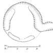
Drawing of Castlelaw Hill ring-ditch house (fig.2). |
2000 |
Item Level |
|
 |
On-line Digital Images |
DP 006537 |
Records of the Royal Commission on the Ancient and Historical Monuments of Scotland (RCAHMS), Edinbu |
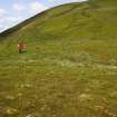
General view from S |
6/6/2005 |
Item Level |
|
 |
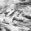
On-line Digital Images |
SC 1680712 |
RCAHMS Aerial Photography |
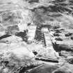
General oblique aerial view centred on the rifle range with the remains of the fort, trenches, ring-ditch house and rig adjacent, taken from the SSE. |
9/2/2004 |
Item Level |
|
 |
On-line Digital Images |
SC 1680713 |
RCAHMS Aerial Photography |
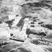
General oblique aerial view centred on the rifle range with the farmhouse and farmsteading and the remains of the fort, trenches, ring-ditch house and rig adjacent, taken from the SSE. |
9/2/2004 |
Item Level |
|
 |
On-line Digital Images |
SC 1680714 |
RCAHMS Aerial Photography |
General oblique aerial view centred on the rifle range with the farmhouse and farmsteading and the remains of the fort, trenches, ring-ditch house and rig adjacent, taken from the SE. |
9/2/2004 |
Item Level |
|
 |
On-line Digital Images |
SC 2442740 |
Records of the Ordnance Survey, Southampton, Hampshire, England |
Castlelaw Hill, NT26SW 44, Ordnance Survey index card, Recto |
1958 |
Item Level |
|
 |
On-line Digital Images |
SC 2442741 |
Records of the Ordnance Survey, Southampton, Hampshire, England |
Castlelaw Hill, NT26SW 44, Ordnance Survey index card, Recto |
1958 |
Item Level |
|


