 |
On-line Digital Images |
SC 1734191 |
RCAHMS Aerial Photography |
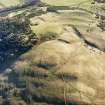
Oblique aerial view of trenches, palisaded settlement and rig, taken from N. |
17/11/2005 |
Item Level |
|
 |
On-line Digital Images |
SC 1734192 |
RCAHMS Aerial Photography |
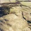
Oblique aerial view of trenches, palisaded settlement and rig, taken from NW. |
17/11/2005 |
Item Level |
|
 |
On-line Digital Images |
SC 1734211 |
RCAHMS Aerial Photography |
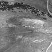
Aerial view |
1981 |
Item Level |
|
|
Digital Files (Non-image) |
GV 008417 |
Records of the Royal Commission on the Ancient and Historical Monuments of Scotland (RCAHMS), Edinbu |
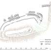
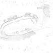
Castle Knowe palisaded settlement, 1:1000 plan |
31/7/2006 |
Item Level |
|
 |
On-line Digital Images |
SC 2151062 |
Records of the Royal Commission on the Ancient and Historical Monuments of Scotland (RCAHMS), Edinbu |
Castle Knowe palisaded settlement, 1:1000 plan |
31/7/2006 |
Item Level |
|
 |
On-line Digital Images |
SC 2151758 |
Records of the Royal Commission on the Ancient and Historical Monuments of Scotland (RCAHMS), Edinbu |
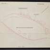
Castle Knowe palisaded settlement, 1:300 plan |
21/8/1982 |
Item Level |
|
 |
On-line Digital Images |
SC 2442697 |
Records of the Ordnance Survey, Southampton, Hampshire, England |
Castle Knowe, NT26SW 21, Ordnance Survey index card, page number 1, Recto |
1958 |
Item Level |
|
 |
On-line Digital Images |
SC 2442698 |
Records of the Ordnance Survey, Southampton, Hampshire, England |
Castle Knowe, NT26SW 21, Ordnance Survey index card, page number 2, Verso |
1958 |
Item Level |
|
 |
On-line Digital Images |
SC 2442699 |
Records of the Ordnance Survey, Southampton, Hampshire, England |
Castle Knowe, NT26SW 21, Ordnance Survey index card, Recto |
1958 |
Item Level |
|
 |
On-line Digital Images |
SC 2442700 |
Records of the Ordnance Survey, Southampton, Hampshire, England |
Castle Knowe, NT26SW 21, Ordnance Survey index card, Recto |
1958 |
Item Level |
|
 |
On-line Digital Images |
SC 2442701 |
Records of the Ordnance Survey, Southampton, Hampshire, England |
Castle Knowe, NT26SW 21, Ordnance Survey index card, Recto |
1958 |
Item Level |
|
 |
On-line Digital Images |
SC 2442702 |
Records of the Ordnance Survey, Southampton, Hampshire, England |
Castle Knowe, NT26SW 21, Ordnance Survey index card, Recto |
1958 |
Item Level |
|
|
All Other |
551 166/1/1 |
Records of the Ordnance Survey, Southampton, Hampshire, England |
Archaeological site card index ('495' cards) |
1947 |
Sub-Group Level |
|


