 |
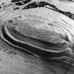
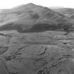
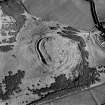
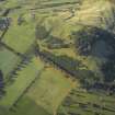
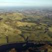
On-line Digital Images |
SC 337218 |
|
Oblique aerial view of fort. |
|
Item Level |
|
 |
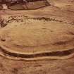
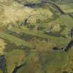
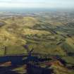
On-line Digital Images |
SC 450991 |
John Dewar |
Oblique aerial view of Castle Law fort and settlement. |
|
Item Level |
|
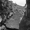 |
On-line Digital Images |
SC 450992 |
|
View of souterrain entrance and stairs. |
|
Item Level |
|
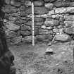 |
On-line Digital Images |
SC 450993 |
|
View of interior of beehive chamber in souterrain showing rock-cut hearth. |
|
Item Level |
|
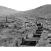 |
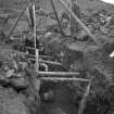
On-line Digital Images |
SC 503875 |
|
Excavation of souterrain |
|
Item Level |
|
 |
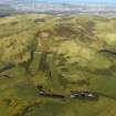
On-line Digital Images |
SC 563298 |
John Dewar |
Oblique aerial view of Castle Law fort and settlement. |
1973 |
Item Level |
|
 |
On-line Digital Images |
SC 563306 |
Vere Gordon Childe |
View of Castle Law fort and settlement showing the souterrain during the excavation in 1932. Dr Margaret E C Stewart is in the photograph. |
1932 |
Item Level |
|
 |
On-line Digital Images |
SC 771152 |
|
Oblique aerial view. Digital image of ML/3412/CS. |
|
Item Level |
|
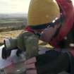 |
On-line Digital Images |
DP 006032 |
Records of the Royal Commission on the Ancient and Historical Monuments of Scotland (RCAHMS), Edinbu |
James Hepher with alidade. |
15/11/2005 |
Item Level |
|
 |
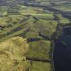
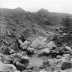
On-line Digital Images |
SC 993181 |
RCAHMS Aerial Photography |
Scanned image of oblique aerial view centred on the remains of the fort and settlement with rig adjacent, taken from the W. |
3/11/2000 |
Item Level |
|
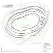 |
On-line Digital Images |
DP 006983 |
Records of the Royal Commission on the Ancient and Historical Monuments of Scotland (RCAHMS), Edinbu |
Castlelaw, Fort, 1:1000 scale plan. |
|
Item Level |
|
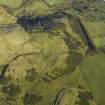 |
On-line Digital Images |
DP 012040 |
RCAHMS Aerial Photography Digital |
Oblique aerial view centred on the remains of the palisaded settlement, cultivation terraces and rig, taken from the SW. |
17/11/2005 |
Item Level |
|
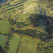 |
On-line Digital Images |
DP 012041 |
RCAHMS Aerial Photography Digital |
General oblique aerial view centred on the remains of the palisaded settlement, cultivation terraces, fort and rig with the rifle ranges adjacent, taken from the ESE. |
17/11/2005 |
Item Level |
|
 |
On-line Digital Images |
DP 012042 |
RCAHMS Aerial Photography Digital |
General oblique aerial view centred on the remains of the palisaded settlement, cultivation terraces, fort and rig with the rifle ranges, farmhouse and farmsteading adjacent, taken from the ENE. |
17/11/2005 |
Item Level |
|
 |
On-line Digital Images |
DP 012044 |
RCAHMS Aerial Photography Digital |
General oblique aerial view centred on the rifle ranges with the farmhouse and farmsteading and remains of the rig, fort, cultivation terraces and palisaded settlement adjacent, taken from the SW. |
17/11/2005 |
Item Level |
|
 |
On-line Digital Images |
DP 012045 |
RCAHMS Aerial Photography Digital |
General oblique aerial view centred on the rifle ranges, farmhouse and farmsteading and the remains of the rig, fort, cultivation terraces and palisaded settlement, taken from the SE. |
17/11/2005 |
Item Level |
|
 |
On-line Digital Images |
DP 012046 |
RCAHMS Aerial Photography Digital |
General oblique aerial view centred on the rifle ranges with the farmhouse and farmsteading and remains of the rig, fort, cultivation terraces and palisaded settlement adjacent, taken from the WNW. |
17/11/2005 |
Item Level |
|
 |
On-line Digital Images |
DP 012047 |
RCAHMS Aerial Photography Digital |
General oblique aerial view centred on the rifle ranges, farmhouse and farmsteading and the remains of the rig, fort, cultivation terraces and palisaded settlement, taken from the SW. |
17/11/2005 |
Item Level |
|
 |
On-line Digital Images |
DP 012048 |
RCAHMS Aerial Photography Digital |
General oblique aerial view centred on the rifle ranges, farmhouse and farmsteading and the remains of the rig, fort, cultivation terraces and palisaded settlement, taken from the SW. |
17/11/2005 |
Item Level |
|
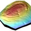 |
On-line Digital Images |
SC 1059248 |
Records of the Royal Commission on the Ancient and Historical Monuments of Scotland (RCAHMS), Edinbu |
Screenshot of the digital terrain model (DTM) of Castlelaw Fort. |
22/2/2007 |
Item Level |
|
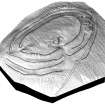 |
On-line Digital Images |
SC 1059249 |
Records of the Royal Commission on the Ancient and Historical Monuments of Scotland (RCAHMS), Edinbu |
Screenshot taken from the 3D visualisation of Castlelaw Fort. Shows the digitised plane table drawing of the fort draped over the 3D topographic surface of the fort. |
22/2/2007 |
Item Level |
|
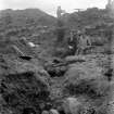 |
On-line Digital Images |
SC 1168421 |
Historic Buildings and Monuments/Scottish Development Department photographs |
Excavation - V G Childe on extreme right of view |
1931 |
Item Level |
|
 |
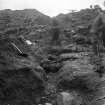
On-line Digital Images |
SC 1168422 |
Historic Buildings and Monuments/Scottish Development Department photographs |
Excavation |
1931 |
Item Level |
|
 |
On-line Digital Images |
SC 1168423 |
Historic Buildings and Monuments/Scottish Development Department photographs |
Excavation |
1931 |
Item Level |
|


