 |
On-line Digital Images |
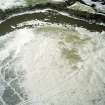
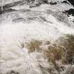
SC 993179 |
RCAHMS Aerial Photography |
Scanned image of oblique aerial view centred on the remains of the palisaded enclosure, taken from the NNW. |
9/2/2004 |
Item Level |
|
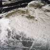 |
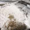
On-line Digital Images |
SC 1734013 |
RCAHMS Aerial Photography |
Oblique aerial view centred on the remains of the palisaded enclosure, taken from the NNE. |
9/2/2004 |
Item Level |
|
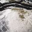 |
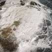
On-line Digital Images |
SC 1734014 |
RCAHMS Aerial Photography |
Oblique aerial view centred on the remains of the palisaded enclosure, taken from the NNW. |
9/2/2004 |
Item Level |
|
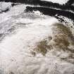 |
On-line Digital Images |
SC 1734015 |
RCAHMS Aerial Photography |
Oblique aerial view centred on the remains of the palisaded enclosure, taken from the W. |
9/2/2004 |
Item Level |
|
 |
On-line Digital Images |
SC 1734016 |
RCAHMS Aerial Photography |
Oblique aerial view centred on the remains of the palisaded enclosure, taken from the WSW. |
9/2/2004 |
Item Level |
|
 |
On-line Digital Images |
SC 1734017 |
RCAHMS Aerial Photography |
Oblique aerial view centred on the remains of the palisaded enclosure, taken from the SE. |
9/2/2004 |
Item Level |
|
 |
On-line Digital Images |
SC 1734018 |
RCAHMS Aerial Photography |
Oblique aerial view centred on the remains of the palisaded enclosure, taken from the ESE. |
9/2/2004 |
Item Level |
|
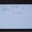 |
On-line Digital Images |
SC 2442461 |
Records of the Ordnance Survey, Southampton, Hampshire, England |
Woodhouselee Hill, NT26NW 31, Ordnance Survey index card, Recto |
1958 |
Item Level |
|
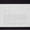 |
On-line Digital Images |
SC 2442462 |
Records of the Ordnance Survey, Southampton, Hampshire, England |
Woodhouselee Hill, NT26NW 31, Ordnance Survey index card, Recto |
1958 |
Item Level |
|


