 |
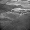
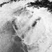
On-line Digital Images |
SC 563296 |
RCAHMS Aerial Photography |
Oblique aerial view. |
1992 |
Item Level |
|
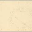 |
On-line Digital Images |
DP 149890 |
Records of the Royal Commission on the Ancient and Historical Monuments of Scotland (RCAHMS), Edinbu |
Plane-table survey: Hillend Fort. |
12/4/1956 |
Item Level |
|
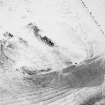 |
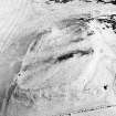
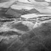
On-line Digital Images |
SC 1733942 |
RCAHMS Aerial Photography |
Oblique aerial photograph |
1986 |
Item Level |
|
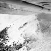 |
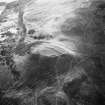
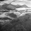
On-line Digital Images |
SC 1733943 |
RCAHMS Aerial Photography |
Oblique aerial photograph |
1986 |
Item Level |
|
 |
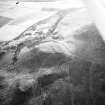
On-line Digital Images |
SC 1733944 |
RCAHMS Aerial Photography |
Oblique aerial photograph |
1986 |
Item Level |
|
 |
On-line Digital Images |
SC 1733945 |
RCAHMS Aerial Photography |
Oblique aerial photograph |
1986 |
Item Level |
|
 |
On-line Digital Images |
SC 1734071 |
RCAHMS Aerial Photography |
Oblique aerial photograph |
1982 |
Item Level |
|
 |
On-line Digital Images |
SC 1734072 |
RCAHMS Aerial Photography |
Oblique aerial photograph |
1982 |
Item Level |
|
 |
On-line Digital Images |
SC 1734073 |
RCAHMS Aerial Photography |
Oblique aerial photograph |
1982 |
Item Level |
|
 |
On-line Digital Images |
SC 1734074 |
RCAHMS Aerial Photography |
Oblique aerial photograph |
1982 |
Item Level |
|
 |
On-line Digital Images |
SC 2442438 |
Records of the Ordnance Survey, Southampton, Hampshire, England |
Hillend, NT26NW 20, Ordnance Survey index card, Recto |
1958 |
Item Level |
|
 |
On-line Digital Images |
SC 2442439 |
Records of the Ordnance Survey, Southampton, Hampshire, England |
Hillend, NT26NW 20, Ordnance Survey index card, page number 1, Recto |
1958 |
Item Level |
|
 |
On-line Digital Images |
SC 2442440 |
Records of the Ordnance Survey, Southampton, Hampshire, England |
Hillend, NT26NW 20, Ordnance Survey index card, page number 2, Verso |
1958 |
Item Level |
|
 |
On-line Digital Images |
SC 2442441 |
Records of the Ordnance Survey, Southampton, Hampshire, England |
Hillend, NT26NW 20, Ordnance Survey index card, Recto |
1958 |
Item Level |
|


