
Harehope


Palisaded Settlement(S) (Prehistoric), Roundhouse(S) (Prehistoric)
Site Name Harehope
Classification Palisaded Settlement(S) (Prehistoric), Roundhouse(S) (Prehistoric)
Canmore ID 51569
Site Number NT24SW 5
NGR NT 2034 4485
Datum OSGB36 - NGR
Permalink http://canmore.org.uk/site/51569


- Council Scottish Borders, The
- Parish Eddleston
- Former Region Borders
- Former District Tweeddale
- Former County Peebles-shire
NT24SW 5 2034 4485.
(NT 2034 4485) Settlement (NR)
OS 6" map (1965)
On the gently sloping E flank of Crailzie Hill there are two palisaded settlements of different dates, the later of which has been constructed within the earlier. Excavations were carried out in the settlements by the Commission in 1960.
The earlier settlement measures 240' by 200' within two low banks (IA, IB) separated by a broad, shallow ditch. The banks were not intended for defence, but each served merely to support a timber palisade which was bedded in a continuous trench. The entrance was on the E, but has largely been obliterated by the secondary occupation.
The later settlement, which is similarly protected by two embanked palisades (IIA, IIB) with an intervening ditch, measures 155' by 120' internally. The entrance, on the E, was cobbled, and the palisades returned and united on either side of the passageway. On the S side a gap in the palisade gave access to a semicircular bay containing a setting of four post holes which were thought to represent the foundations of a small tower. A complementary bay on the N side presumably contained a similar structure.
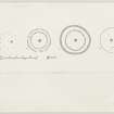
Excavation in the centre of the interior revealed traces of three superimposed circular houses. The earliest of these, 24' in diameter, consisted of a simple ring of six large post-holes, while the second house was represented by a fragmentary groove, about 20' in diameter, with associated post-holes. The latest house comprised a ring of six post-holes surrounded by a concentric trench in which the timbers of the outer wall, 36ft in diameter had been set.
This type of house corresponds to the later of the two found in the pre-Roman Iron Age homestead at West Plean, Stirlingshire, and is exactly paralled in a homestead on Brandon Moor, County Durham. It seems likely that the earliest house, indicated by the ring of large post-holes, was erected before the defences now visible were made, and that the two later houses represent the same two structural periods that are present in the palisaded works.
RCAHMS 1967, visited 1960; R W Feachem 1962
A fine example of a settlement as described.
Visited by OS (JLD) 3 May 1962 and (BS) 25 September 1974
Photographed by the RCAHMS in 1980.
Worn beehive quern; RMS HH 661.
E J MacKie 1971
Sbc Note
Visibility: This site has been excavated.
Information from Scottish Borders Council

