
Posso Tower


Tower House (Medieval)
Site Name Posso Tower
Classification Tower House (Medieval)
Alternative Name(s) Posso House
Canmore ID 51358
Site Number NT23SW 17
NGR NT 20014 33243
Datum OSGB36 - NGR
Permalink http://canmore.org.uk/site/51358


- Council Scottish Borders, The
- Parish Manor
- Former Region Borders
- Former District Tweeddale
- Former County Peebles-shire
NT23SW 17.00 20014 33243
NT23SW 17.01 200 332 garden; sundial
(NT 2000 3324) Posso (NR) (remains of)
OS 6" map (1965)
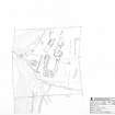
The last vestiges of the old house of Posso comprise a tower-house with associated out-buildings and earthworks but these are now so ruinous that their general disposition can most readily be grasped by reference to the site plan.
The tower itself still the most conspicuous feature of the remains, stands towards the NW corner of the site and measures 30 ft 9 in by 24 ft 6 in over walls having a thickness of 4 ft 1 in at first floor level; the W wall rises in part to a point slightly above second-floor level but the other walls are reduced to no more than a single storey in height, and the interior is choked with debris.
Immediately to the S of the tower, but apparently detached from it, there stood a rectangular building measuring about 35 ft from N to S by 24 ft from W to E over all; this structure is now reduced to the lowest courses of its walls, which are turf-covered. There was a more extensive range of out-buildings a little to the E of the tower, measuring about 68 ft from N to S and 20 ft 6 in from W to E over walls 2ft 7 in in thickness, and having a small wing, perhaps a stair-tower projecting from the centre of its W wall The N end of this building is now represented only by foundations, but the S end of the W wal stands almost to first- floor level, and the S gable-wall to the height of two full storeys.
Immediately to the S of the out-buildings a modern track traverses the site from W to E and between this track and the Tower Burn there are extensive traces of earth- works, perhaps the remains of orchards and gardens. The principal feature of the earthworks is a series of five terraces measuring about 95 ft in length, and varying in width from 45 ft to 10 ft. Facing the centre of the uppermost terrace there is an open-ended rectangular enclosure (A) measuring about 15 ft by 9 ft internally. At the S end of the broadest terrace there is a small, sub-rectangular platform with rounded corners (B) surrounded by a well-preserved ditch and bank. The platform measures 13 ft by 14 ft over all, while the ditch measures 8 ft in width at base, and has a maximum depth of 4 ft below the outer bank. This feature may perhaps best be explained as an ornamental pond, once fed at its SW angle by means of a channel leading from the Tower Burn of which slight traces can still be seen. The remains of an enclosure dyke bound the site on the S running for part of its course upon the N bank of the Tower Burn.
The earliest structure on the site is probably the tower, and this may be ascribed to about the first half of the 16th century, the outbuildings and earthworks may in part be contemporary and in part of slightly later date.
RCAHMS 1967, visited 1962
The two surviving pieces of walls and the grass-covered remains are as described.
Revised at 1/2500.
Visited by OS (WDJ) 17 May 1962 and (BS) 9 October 1974.
Ground Survey (20 March 2008)
Survey of the garden at Posso Tower.
Note (3 November 2015)
This monument was delisted and was removed from the list of buildings of special architectural or historic interest.
The structure is still designated as a scheduled monument under the Ancient Monuments and Archaeological Areas Act 1979.
Information from Historic Environment Scotland, 3rd November 2015
Sbc Note
Visibility: This is an upstanding earthwork or monument.
Information from Scottish Borders Council

