
Wood Hill


Enclosure (Prehistoric), Fort (Prehistoric), Roundhouse (Prehistoric)
Site Name Wood Hill
Classification Enclosure (Prehistoric), Fort (Prehistoric), Roundhouse (Prehistoric)
Alternative Name(s) Macbeth's Castle
Canmore ID 51350
Site Number NT23SW 1
NGR NT 2054 3341
Datum OSGB36 - NGR
Permalink http://canmore.org.uk/site/51350


- Council Scottish Borders, The
- Parish Manor
- Former Region Borders
- Former District Tweeddale
- Former County Peebles-shire
NT23SW 1 2054 3341.
(NT 2054 3341) Macbeth's Castle (NAT) Fort (NR)
OS 6" map (1965)
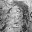
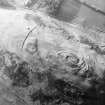
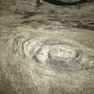
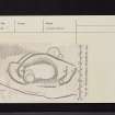
On and around the rocky knoll that crowns the summit of Wood Hill there is an Early Iron Age fort and an enclosure of later date. Locally the remains are collectively known as Macbeth's Castle. The fort, represented on the plan (RCAHMS 1957) by ramparts IA, IB, IC and ID has enclosed an area measuring about 200ft by 100ft.
All the ramparts are heavily denuded, and for the most part they appear simply as scarps. Except on the N where it is represented by a low stony bank measuring 15ft in thickness, the innermost rampart (IA) is overlain by the enclosure wall (II). The entrance in IA was presumably on the SSE in line with gaps in IA and IC, and it is possible that two earthfast boulders visible in this sector of the debris of wall II represent the revetment of one side of the original entrance-passage. The enclosure wall (II) follows the line of rampart IA except on the N where it lies 30 ft inside it, and also on the NW where it runs down the flank of the knoll to form a salient. The wall is now represented by a considerable amount of debris in which several stretches of the outer face, but none of the inner, are visible. The entrance is on the NW. No traces of dwellings of either period are distinguishable in the interior, and the only feature is a quarry of comparatively recent date, surrounded by a now ruinous drystone wall.
The foundation of a circular stone-walled house (1), measuring 20ft in internal diameter, partly overlies rampart IC on the SW while a smal stone-walled enclosure measuring about 60ft across it attached to the outer side of the medial rampart on the SE.
RCAHMS 1967, visited 1962
As described.
Visited by OS (BS) 1 October 1974
Occupying the rocky knoll on the summit of Wood Hill, there are the remains of three successive forts. The first, though largely conjectural, seems to be of univallate type, subsequently strengthened in a second phase by the addition of a further two ramparts. The third fort is closely tailored to the summit with the considerable rubble spread in which several stretches of the outer-face are visible; the entrance was on the NW. The footings of a stone-walled round house, on the SW, partially overlie the outer rampart of the second fort, while on the SE, adjoining the medial rampart, there are the remains of a small enclosure of crab-claw form.
I M Smith 1990, visited July 1981
Note (20 October 2015 - 4 August 2016)
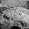
This fort crowns the summit of Wood Hill, which rises out of the floor of the Manor valley between Posso on the W and Glenrath on the E. The defences of the fort comprise two probably successive elements, the later a roughly oval circuit with a thick stone wall, and the earlier a less regular enclosure with up to three ramparts. The wall of the oval enclosure, which measures internally some 53m from N to S by 26m transversely (0.14ha), was thought by RCAHMS investigators in 1962 to largely overlie and mask the inner rampart of the earlier fort, though there is little evidence to demonstrate this is the case, apart from where it cuts across the earlier interior on the N. The whole of this later circuit is characterised by a massive scree of rubble in which occasional outer facing-stones are visible, extending around the flanks of the summit and dismounting only on the NW to either side of an entrance; some of the facing of a possible second entrance was noted in the rubble on the SSE. The N arc of the earlier inner rampart appears to disappear beneath the later wall on the W side of the summit, but while it may follow a similar course on the E side, the extension of its line on the plan follows a stony scarp down the slope and around the E flank, probably forming a rather larger enclosure with what the investigators believed was the second rampart at the S end. This is perhaps a more likely configuration of the earlier defences, with two roughly concentric ramparts around the N, W and S, terminating on the S at an entrance formed with the single rampart on the E. If this is correct, the interior of the fort is rather larger than has been recognised previously, measuring 80m from N to S by about 40m transversely (0.3ha). The outermost element in the defences recorded on the RCAHMS plan lies a further 10m to 20m down the slope on the N and W; projected, this would have formed a much bigger enclosure on the hilltop, but it is uncertain whether this is the remains of a rampart or perhaps no more than a later agricultural boundary on the hill. While the interior of the fort is featureless, a stony ring-bank overlies the defences on the SSW.
Information from An Atlas of Hillforts of Great Britain and Ireland – 04 August 2016. Atlas of Hillforts SC3658
Sbc Note
Visibility: This is an upstanding earthwork or monument.
Information from Scottish Borders Council

