
Following the launch of trove.scot in February 2025 we are now planning the retiral of some of our webservices. Canmore will be switched off on 24th June 2025. Information about the closure can be found on the HES website: Retiral of HES web services | Historic Environment Scotland
Waddenshope


Fort (Prehistoric), Palisade(S) (Period Unassigned), Ring Ditch House(S) (Prehistoric)
Site Name Waddenshope
Classification Fort (Prehistoric), Palisade(S) (Period Unassigned), Ring Ditch House(S) (Prehistoric)
Canmore ID 51242
Site Number NT23NE 14
NGR NT 2673 3680
Datum OSGB36 - NGR
Permalink http://canmore.org.uk/site/51242


- Council Scottish Borders, The
- Parish Peebles
- Former Region Borders
- Former District Tweeddale
- Former County Peebles-shire
NT23NE 14 2673 3680.
(NT 2673 3680) Fort (NR)
OS 6" map (1965)
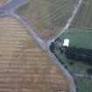
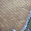
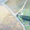
Fort, Waddenshope. A bivallate fort measuring internally 200 ft by 110 ft. For the most part both ramparts are now reduced to mere scarps, but on either side of an entrance at the SE end they appear as low stony banks accompanied in each case by an external quarry-ditch. The broad space that has been left between the ramparts on the SE was possibly designed to provide a corral for beasts.
There is a second entrance to the fort on the W and the interior contains the surface traces of two timber houses. One of them (1) is represented simply by a crescentric scarp and the other (2) by a similar scarp which merges with a shallow, narrow ditch to enclose an area measuring 30 ft in diameter. A quarry has encroached upon the NE part of the fort, and a modern wall overlies the SE sector of the outer rampart. (Information from A McLaren notebook 1951-4, 19)
RCAHMS 1967, visited 1952
This earthwork is generally as described. Although situated on the end of a steep sided spur it is easily approached from the S, and is more likely to be a settlement.
Visited by OS (EGC) 3 August 1961 and (SFS) 3 December 1974
The earthworks of this settlement are generally as described but at SE end palisade trenches cut across the ridge immediately outside both of the ditches. Traces of the outer are also visible as a scarp on the SW side and at the NW end, where it is overlain by the plantation. Within the interior there are at least five ring-ditch houses.
Visited by RCAHMS (SH) 3 July 1989.
Reference (1957)
This site is noted in the ‘List of monuments discovered during the survey of marginal land (1951-5)’ (RCAHMS 1957, xiv-xviii).
Information from RCAHMS (GFG), 24 October 2012.
Note (16 October 2015 - 31 August 2016)
This fort is situated at the N tip of a long spur dropping down from Dead Side between the Waddenshope and Glensax Burns, and is set at the point where the ground falls away more steeply on the N down to the cottage at Waddenshope. Oval on plan, the defences comprise inner and outer enclosures, the inner measuring internally 58m from NW to SE by 30m transversely (0.16ha). The enclosing rampart has been reduced to a low stony bank to either side of the entrance on the SE, and elsewhere to a scarp; on the SE, which is also the easiest line of approach, it is accompanied by an external ditch, 5m beyond which, and unrecognised when RCAHMS investigators drew up a plan in 1952 (RCAHMS 1967, 146-7, no.324, fig 138), are traces of a concentric palisade trench. The outer enclosure is not concentric, its rampart lying from 12m to 28m outside the inner on the NW and SE respectively, and 5m along the flanks, and again is largely reduced to a scarp but forms a low bank to either side of the entrance on the SE. Here too it is accompanied by an external ditch, outside which there is a concentric palisade trench, the latter possibly also visible as a low scarp at the NW end of the fort. A second entrance pierces both ramparts obliquely on the W, exposing the visitor's left side, and within the inner enclosure there are traces of at least five ring-ditch houses, only two of which appear on the plan. Conventionally the inner and outer enclosures have been seen as a contemporary scheme of defence, and the palisades would be regarded as an earlier phase of enclosure. Whether the former hypothesis can be neither demonstrated or contradicted on the basis of the field evidence, it is worth considering also that the palisade trenches here may be complementary elements in a contemporary defensive scheme with both stone and timber components.
Information from An Atlas of Hillforts of Great Britain and Ireland – 31 August 2016. Atlas of Hillforts SC3643
Sbc Note
Visibility: This is an upstanding earthwork or monument.
Information from Scottish Borders Council

