
Charles Hill, Monks' Cave


Building (Medieval), Graffiti (20th Century) - (21st Century), Magazine (Second World War)
Site Name Charles Hill, Monks' Cave
Classification Building (Medieval), Graffiti (20th Century) - (21st Century), Magazine (Second World War)
Alternative Name(s) St Colme House Policies
Canmore ID 50872
Site Number NT18SE 1
NGR NT 18576 83705
Datum OSGB36 - NGR
Permalink http://canmore.org.uk/site/50872


- Council Fife
- Parish Dalgety
- Former Region Fife
- Former District Dunfermline
- Former County Fife
NT18SE 1 1857 8369
Monk's Cave (NR)
OS 6" map, Fife (1928).
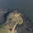
The Monk's Cave, on Charles Hill, is entirely artificial and is really the lower storey of a building, probably a ferry-house and warehouse connected with Inchcolm Abbey (NT18SE 7). The building stands on the edge of a low cliff which has been partly excavated; the doorway, of 15th century date, opens into a vaulted cellar, 15' x 25 1/2'. The upper storey has been reduced to the level of the upper surface of the vault supporting it. The overall dimensions are 69' x 26 1/4'.
RCAHMS 1933, visited 1928.
Monk's Cave, in good condition, is as described above, a flight of modern steps has been erected against the outside of the S wall.
Visited by OS (AC), 11 March 1959.
(NT 1857 8369) Monks' Cave (NR)
OS 6" map, Fife (1967).
No change to previous field report.
Visited by OS (BS), 17 December 1975.
Field Visit (23 July 1928)
The Monk's Cave.
On Charles Hill, a promontory between Barnhill and Braefoot bays opposite Inchcolm, is the structure known as the Monk's Cave. It is entirely artificial and is really the lower storey of a building, which was probably a ferry-house and warehouse in connection with Inchcolm Monastery. Braefoot
Bay provides a sheltered landing for small boats and still contains the remains of a boatslip.
The building stands on the edge of a low cliff, which has been partly excavated to accommodate it, and the entrance faces seaward. The doorway, 3 ½ feet wide and fitted for outer and inner doors, dates from the late 15th century; the head is semi-circular, and its joints are joggled.
The entrance opens into a vaulted cellar, measuring 15 by 25 ½ feet, which is lit only from a small oval window set high up on the west of the entrance. The upper storey has been reduced to the level of the upper surface of the vault supporting it, which is at the general level of the site. No details can be given other than the over-all dimensions of the structure, 69 by 26 ¼ feet.
RCAHMS 1933, visited 23 July 1928.
Field Visit (25 July 2022)
Rockets intended for use in the defence of the battery during the Second World War were stored in the late medieval building known as the Monk’s Cave (for the rocket launch pads see NT18SE 27.05). The architectural details of this building, which largely comprises a vaulted ground floor set into a rock-cut excavation, are as previously described. No internal fittings, including a secure door, from the Second World War remain and the only physical evidence for use at that time is a set of concrete steps installed by the army to provide access from above down the S side of the structure to the level of the entrance.
Visited by HES Archaeological Survey (J. Sherriff; A. McCaig) 25 July 2022.

