
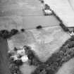
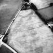
Harestanes


Stone Circle (Neolithic) - (Bronze Age)
Site Name Harestanes
Classification Stone Circle (Neolithic) - (Bronze Age)
Alternative Name(s) Old Harestanes
Canmore ID 50110
Site Number NT14SW 4
NGR NT 1240 4432
Datum OSGB36 - NGR
Permalink http://canmore.org.uk/site/50110


- Council Scottish Borders, The
- Parish Kirkurd
- Former Region Borders
- Former District Tweeddale
- Former County Peebles-shire
NT14SW 4 1240 4432.
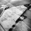
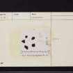
(NT 1240 4432) Stone Circle (NR)
OS 6" map (1968)
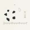
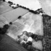
This stone circle conssits of four large conglomerate boulders, varying from 2'-4' in height, and a fifth broken off at ground level, arranged on the circumference of a circle 10' in internal diameter. A sixth stone, 5' E of the truncated one, has probably been broken off the latter and moved to its present position in recent times. A thin sandstone slab protruding through the turf outside the NE arc of the circle is not earthfast, and is unlikely to have formed part of the monument. No comparable monument exists in Peeblesshire, but one near Penmaenmawr, Caernarvonshire, dateable to the Middle Bronze Age, is strikingly similar.
(Information from R W Feachem notebook 1955-7, i, 68)
RCAHMS 1967, visited 1956
A small stone circle as described.
Visited by OS (WDJ) 15 July 1964 and (SFS) 29 October 1974
Sbc Note (15 April 2016)
Visibility: Standing structure or monument.
Information from Scottish Borders Council

