
Yell, Aastack


Stack Site (Period Unassigned)
Site Name Yell, Aastack
Classification Stack Site (Period Unassigned)
Canmore ID 5
Site Number HP40SE 2
NGR HP 477 044
Datum OSGB36 - NGR
Permalink http://canmore.org.uk/site/5


- Council Shetland Islands
- Parish Yell
- Former Region Shetland Islands Area
- Former District Shetland
- Former County Shetland
HP40SE 2 477 044.
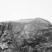
HP 477 044. A very considerable turf or earth parapet is visible around the landware-facing edge of Aastack, an isolated rock stack. The headland opposite is cup off by the remains of two stone dykes, just E (ie landward) of which is a low, grass-grown cairn. The dykes run only a few yards from the cliff edge and do not enclose a significant area, unless it is imagined that they formed an outer boundary to the structure on the stack, which may have been joined to the mainland in antiquity.
This is a likely site for a monastic settlement.
Information from R G Lamb, Edinburgh University, 12 January 1972.
Note (4 March 2016 - 18 May 2016)
An isolated sea stack on the NW coast of Yell, which is now separated from the mainland by a chasm 55m wide and 40m deep, had traces of a substantial bank along its landward lip when first observed by Raymond Lamb in 1971 (1976, 153). No trace of this bank is visible on the available satellite imagery, which shows that the upper part of the sloping seaward side is made up of grass an rock across an irregular area measuring 55m from NE to SW by up to 40m transversely (0.18ha). Beyond this the rocks dip down to the sea over a distance of another 50m. On the landward side of the chasm two old dykes are visible and Lamb suggested that these related to the use of the headland before it became so heavily eroded and possibly when the stack was still connected to the mainland. Certainly the only way of accessing the stack in its present form would be to land by boat on the rocks on its seaward side. While Lamb speculated that this was an early monastic site, its character is quite unknown.
Information from An Atlas of Hillforts of Great Britain and Ireland – 18 May 2016. Atlas of Hillforts SC4198

