
Henry's Brae


Fort (Prehistoric), House Platform(S) (Prehistoric), Ring Groove House(S) (Prehistoric), Sheepfold (Modern)
Site Name Henry's Brae
Classification Fort (Prehistoric), House Platform(S) (Prehistoric), Ring Groove House(S) (Prehistoric), Sheepfold (Modern)
Alternative Name(s) Vane Law
Canmore ID 49913
Site Number NT13SW 22
NGR NT 1395 3410
Datum OSGB36 - NGR
Permalink http://canmore.org.uk/site/49913


- Council Scottish Borders, The
- Parish Drumelzier
- Former Region Borders
- Former District Tweeddale
- Former County Peebles-shire
NT13SW 22 1395 3410
(NT 1395 3410) Fort (NR)
OS 6" map, (1967).
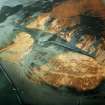
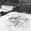
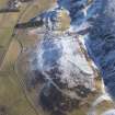
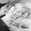
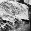
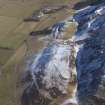
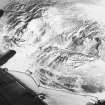
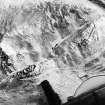
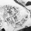
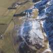
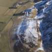
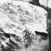
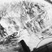
This fort which occupies a ridge cut off from Vane Law by a marginal meltwater channel, measures internally 800ft by 235ft and has been defended by a single stone wall 10ft in thickness. On the W side the wall now appears as a band of tumbled debris from which numerous outer facing stones and one short stretch of the inner face protrude, but elsewhere the faces and the core have either been removed or have fallen down the flanks of the ridge. The entrance, situated in the middle of the W side, is 10ft in width and leads into a hollow measuring 40ft in length by 25ft in width. Another gap in the wall, at the NNE end, may have been broken through comparatively recently, when the NE part of the fort was under cultivation.
Within the interior, which measures 3 1/2 acres in extent, the surface traces of at least twenty-eight house- platforms can be discerned, while a good many more may originally have existed in the ploughed NE portion. A few of the platforms are accompanied by shallow grooves, indicating that the houses were of ring-groove type.
A modern sheepfold overlies the SSW end of the fort.
D Christison 1887; RCAHMS 1967, visited 1956.
Generally as described. Only fifteen house platforms can be identified.
Resurveyed at 1/2500.
Visited by OS (IA) 16 August 1972.
The fort is visible on vertical aerial photographs (OS 71/395/015 and 031, flown 1971).
Information from RCAHMS (RJCM), April 1995.
Note (12 October 2015 - 16 August 2016)
This fort is situated on the SSW end of a ridge formed where a glacial meltwater channel has cut down through the W spur of Vane Law. A elongated triangle on plan, it measures internally some 240m in length and tapers southwards from 70m in breadth at the NNE end (1.4ha). The defences comprise a single wall 3m in thickness which can be followed along the W flank, forming a scree of rubble with occasional runs of the outer face visible; towards the NNE end a single run of inner face can also be seen. The wall seems to have returned along the lip of a steep natural scarp at the NNE end, but no trace of it is visible along the lip of the meltwater channel on the E. An entrance midway along the W side opens into a deeply eroded hollow, and there is possibly a second entrance in the middle of the NNE end, though RCAHMS investigators in 1956 were of the opinion that this may been created to facilitate the cultivation of the NE end of the interior. Why they believed this end had been cultivated is not clear, other than traces of house platforms are only visible on the upper slopes, contrasting with the way they are disposed across the SW end. In all, the plan drawn up in 1956 shows no fewer than twenty-eight platforms, five of which have traces of a groove extending around the uphill side, and while the OS subsequently identified only fifteen, there can be no doubt that the interior has been densely occupied. The only other feature visible within the interior is a stone-walled sheepfold formed out of the southern tip of the defences.
Information from An Atlas of Hillforts of Great Britain and Ireland – 16 August 2016. Atlas of Hillforts SC3620
Sbc Note
Visibility: This is an upstanding earthwork or monument.
Information from Scottish Borders Council

