
Posso Craig


Enclosure(S) (Period Unassigned), Rig And Furrow (Medieval) - (Post Medieval), Site (Period Unassigned)
Site Name Posso Craig
Classification Enclosure(S) (Period Unassigned), Rig And Furrow (Medieval) - (Post Medieval), Site (Period Unassigned)
Canmore ID 49895
Site Number NT13SE 6
NGR NT 1995 3109
Datum OSGB36 - NGR
Permalink http://canmore.org.uk/site/49895


- Council Scottish Borders, The
- Parish Manor
- Former Region Borders
- Former District Tweeddale
- Former County Peebles-shire
NT13SE 6 1995 3109.
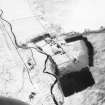
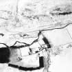
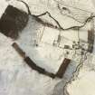
NT 199 311 : Indeterminate Remains, Posso Craig. These remains are situated at the foot of Posso Craig, 290 yds NW of Langhaugh farmhouse. They comprise: (i) two quarried platforms (A and B on RCAHMS 1967 plan, fig.313);
(ii) a U-shaped enclosure (C) measuring 35ft in length by 15ft in width and bounded by a ruined wall 2ft 6in in thickness. From the W end of the enclosure a similar ruined wall runs SW for 50ft to the edge of platform B;
(iii) an enclosure (D) measuring 28ft by 23ft within a low bank 6ft thick; (iv) a small depression (E) measuring 3ft in depth and partly surrounded by a low bank; and (V) three stone-heaps presumably formed in the process of clearing land for cultivation.
RCAHMS 1967, visited 1962; Information from R W Feachem notebook 1961-2, 80.
NT 1995 3109: These remains are situated within an area of rig and furrow and may be the last vestiges of an associated farmstead.
Visited by OS(EGC) 21 June 1961 and (BS) 4 October 1974.
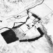
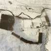
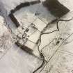
(NT 1996 3112). At the margin of the cultivated ground on the SE side of Posso Craig, on the left bank of the Manor Water opposite Langhaugh, there is an irregular shaped knoll. The summit is enclosed by a low wall, within and around which there are traces of a number of scarps that may be hut-stances. Partially eclipsing the knoll and extending to the haughland to the E, there are several swathes of broad, reverse-S cultivation ridges, while to the W, and extending to the confluence of the Newholmhope Burn and the Manor Water, there is an extensive cairnfield.
In broken ground on the S flank of Posso Craig, there are the turf-covered stone-wall footings of an open-ended rectangular structure (possibly a pen) which is connected by a dyke to the first of two house-platforms set roughly parallel with each other. About 30m to the S, there is an enclosure and what may be a bowl-kiln, and close by there at least three clearance cairns.
I M Smith 1990, visited July 1981
Sbc Note
Visibility: This is an upstanding earthwork or monument.
Information from Scottish Borders Council

