 |
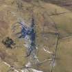
On-line Digital Images |
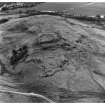
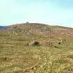
SC 337156 |
RCAHMS Aerial Photography |
Oblique aerial view. |
1981 |
Item Level |
|
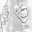 |
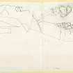
On-line Digital Images |
SC 337268 |
Records of the Royal Commission on the Ancient and Historical Monuments of Scotland (RCAHMS), Edinbu |
Publication drawing; plan of fort and settlements X and Y, Dreva. Photographic copy. |
c. 1958 |
Item Level |
|
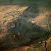 |
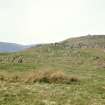
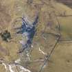
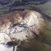
On-line Digital Images |
SC 693979 |
RCAHMS Aerial Photography |
Oblique aerial view of Dreva Craig centred on the reamins of a fort, taken from the ESE.
Digital image of D/69846/CN. |
15/1/2001 |
Item Level |
|
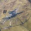
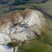 |
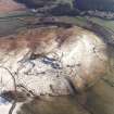
On-line Digital Images |
SC 702714 |
RCAHMS Aerial Photography |
Oblique aerial view of Dreva Craig |
2002 |
Item Level |
|
 |
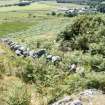
On-line Digital Images |
SC 743498 |
Papers of Helen Cameron Nisbet, geologist and archaeologist, Lasswade, Midlothian, Scotland |
Copy of colour slide showing view of Dreva Fort, Peeblesshire - view from SW showing chevaux de frises
NMRS Survey of Private Collection
Digital Image only |
4/5/1975 |
Item Level |
|
 |
On-line Digital Images |
SC 743501 |
Papers of Helen Cameron Nisbet, geologist and archaeologist, Lasswade, Midlothian, Scotland |
Copy of colour slide showing view of Dreva Fort, Peeblesshire - chevaux de frises on SW side
NMRS Survey of Private Collection
Digital Image only |
4/5/1975 |
Item Level |
|
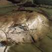 |
On-line Digital Images |
SC 1004855 |
RCAHMS Aerial Photography |
Oblique aerial view centred on the remains of the fort, settlements and field system with the farmsteading adjacent, taken from the N. |
28/2/2002 |
Item Level |
|
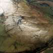 |
On-line Digital Images |
SC 1004856 |
RCAHMS Aerial Photography |
Oblique aerial view centred on the remains of the fort, settlements and field system, taken from the SW. |
28/2/2002 |
Item Level |
|
 |
On-line Digital Images |
DP 085996 |
RCAHMS Aerial Photography Digital |
Oblique aerial view of Dreva Craig fort, settlements and field system, looking WSW. |
2/3/2010 |
Item Level |
|
 |
On-line Digital Images |
DP 085997 |
RCAHMS Aerial Photography Digital |
Oblique aerial view of Dreva Craig fort, settlements and field system, looking SW. |
2/3/2010 |
Item Level |
|
 |
On-line Digital Images |
DP 085998 |
RCAHMS Aerial Photography Digital |
Oblique aerial view of Dreva Craig fort, settlements and field system, looking SSE. |
2/3/2010 |
Item Level |
|
 |
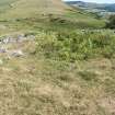
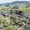
On-line Digital Images |
DP 277261 |
Historic Environment Scotland |
The entrance to the inner wall of the fort at Dreva Craig, clearly modified by later work |
6/7/2018 |
Item Level |
|
 |
On-line Digital Images |
DP 277262 |
Historic Environment Scotland |
Fort interior. The footings of what has been interpreteted as a roundhouse, secondary to the fort wall. |
6/7/2018 |
Item Level |
|
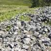 |
On-line Digital Images |
DP 277263 |
Historic Environment Scotland |
General view of the collapsed inner wall along the NE, with later structures |
6/7/2018 |
Item Level |
|
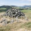 |
On-line Digital Images |
DP 277264 |
Historic Environment Scotland |
The modern marker cairn within the fort at Dreva Craig |
6/7/2018 |
Item Level |
|
 |
On-line Digital Images |
DP 277265 |
Historic Environment Scotland |
The inner wall of the fort along the SW, where it may have been exposed by antiquarian digging |
6/7/2018 |
Item Level |
|
 |
On-line Digital Images |
DP 277266 |
Historic Environment Scotland |
A large and relatively recent structure constructed within the fort wall at the S |
6/7/2018 |
Item Level |
|
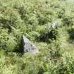 |
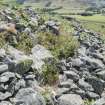
On-line Digital Images |
DP 277267 |
Historic Environment Scotland |
Two stones which form part of the chevaux de frise |
6/7/2018 |
Item Level |
|
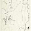 |
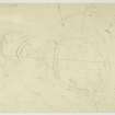
On-line Digital Images |
DP 278368 |
Records of the Royal Commission on the Ancient and Historical Monuments of Scotland (RCAHMS), Edinbu |
Publication drawing; fort, settlements and field system, Dreva |
25/2/1964 |
Item Level |
|
 |
On-line Digital Images |
DP 278369 |
Records of the Royal Commission on the Ancient and Historical Monuments of Scotland (RCAHMS), Edinbu |
Plane table survey: Fort and Settlement, Dreva Hill, p.4 of 10 |
4/1958 |
Item Level |
|
 |
On-line Digital Images |
DP 278371 |
Records of the Royal Commission on the Ancient and Historical Monuments of Scotland (RCAHMS), Edinbu |
Reduced photocopy of detailed plans, to support creation of PBD 101/1 (Fig. 90) |
c. 1964 |
Item Level |
|
 |
On-line Digital Images |
DP 278375 |
Records of the Royal Commission on the Ancient and Historical Monuments of Scotland (RCAHMS), Edinbu |
Plane-table survey: Dreva Hill (Sheet 1 of 10); fort and chevauz de frise. |
9/4/1958 |
Item Level |
|
 |
On-line Digital Images |
SC 1732072 |
RCAHMS Aerial Photography |
Oblique aerial view centred on the remains of the fort, settlements and field system with the farmsteading adjacent, taken from the NNE. |
28/2/2002 |
Item Level |
|
 |
On-line Digital Images |
SC 1732073 |
RCAHMS Aerial Photography |
Oblique aerial view centred on the remains of the fort, settlements and field system with the farmsteading adjacent, taken from the N. |
28/2/2002 |
Item Level |
|


