
Craigluscar


Enclosure (Medieval) - (Post Medieval), Shieling Hut(S) (Medieval) - (Post Medieval)
Site Name Craigluscar
Classification Enclosure (Medieval) - (Post Medieval), Shieling Hut(S) (Medieval) - (Post Medieval)
Canmore ID 49668
Site Number NT09SE 2
NGR NT 0625 9100
NGR Description Centred NT 0625 9100
Datum OSGB36 - NGR
Permalink http://canmore.org.uk/site/49668


- Council Fife
- Parish Dunfermline
- Former Region Fife
- Former District Dunfermline
- Former County Fife
NT09SE 2 centred 0625 9100
The only other structures near the fort (Craigluscar -33 SE) are some rectangular mounds of earth on the ridge a short distance to the east. They may perhaps be an unusual type of cairn, or, more probably, the remains of huts built with thick walls of cob.
A H A Hogg 1953.
Crofts at Craigluscar Hill, Dunfermline.
RCAHMS 1957.
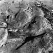
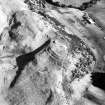
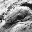
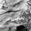
On the summit of the ridge c 200m east of Craigluscar Fort on a gentle north-facing shape, is a cluster of 14 small rectangular foundations of turf, and a small paddock. Most of the foundations are filled in and now appear as low mounds c 0.3m high. The foundations vary from c 4 X3m - c 8 X4m. Very little stonework was encountered in them; and no trace of an enclosing wall or bank was found around the site. These would appear to be the remains of Shielings.
Surveyed at 1/2500.
Visited by OS (JLD) 28 March 1961.
A group of shieling-huts, centred on NT 0625 9100 (Figs 13-27). At NT 0625 9100, there is a square grass covered enclosure (fig.34), with a break in the bank of 0.75m on the S side. The shielings are situated on the flat topped ridge. (figs.13-27)
EUCFA 1988.
Scheduled as Craigluscar, shielings and enclosure.
Information from Historic Scotland, scheduling document dated 18th February 2001.
Field Visit (10 April 1951)
NT 062 910. Crofts, Craigluscar Hill. On Craigluscar hill, 200 yds E of Castle Craig fort and at a height of 700ft OD, there are the foundations of a group of a dozen primitive structures probably dating to medieval times. All the structures are rectangular on plan with rounded corners, and have turf or clay walls, 3ft to 4ft think at the base, in some cases surrounded by a slight drainage ditch. Several double-roomed examples, measuring 32ft by 14ft over the walls, are presumably houses; while the rest, all of which have only a single room, may be either houses or byres. A small, square, turf-walled enclosure on the N side of the group may be contemporary. About 200 yds NE of this group there is a second group of similar structures.
Visited by RCAHMS (KAS) 10 April 1951.
Reference (1957)
This site is noted in the ‘List of monuments discovered during the survey of marginal land (1951-5)’ (RCAHMS 1957, xiv-xviii).
Information from RCAHMS (GFG), 24 October 2012.

