 |
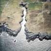
On-line Digital Images |
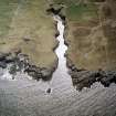
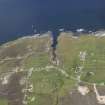
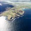
SC 961341 |
RCAHMS Aerial Photography |
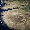
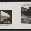
Oblique aerial view centred on the Smoo cave with the remains of the radar station and crofting townships adjacent, taken from the NE. |
28/4/2004 |
Item Level |
|
 |
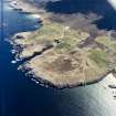
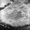
On-line Digital Images |
SC 961342 |
RCAHMS Aerial Photography |
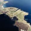
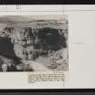
General oblique aerial view centred on the crofting townships, cave and the remains of the radar station, taken from the NNE. |
28/4/2004 |
Item Level |
|
 |
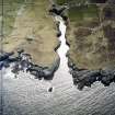
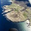
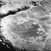
On-line Digital Images |
SC 961343 |
RCAHMS Aerial Photography |
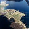
General oblique aerial view centred on the crofting townships, cave and the remains of the radar station, taken from the NW. |
28/4/2004 |
Item Level |
|
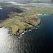 |
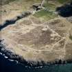
On-line Digital Images |
SC 961344 |
RCAHMS Aerial Photography |
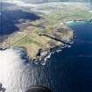
General oblique aerial view looking across the crofting townships, cave and the remains of the radar station towards the Kyle of Durness, taken from the E. |
28/4/2004 |
Item Level |
|
 |
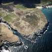
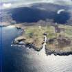
On-line Digital Images |
DP 093017 |
RCAHMS Aerial Photography Digital |
Oblique aerial view of Smoo Cave and Leirinmore, taken from the SSW. |
23/7/2010 |
Item Level |
|
 |
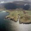
On-line Digital Images |
SC 1676811 |
RCAHMS Aerial Photography |
Oblique aerial view centred on the remains of the radar station with caves and crofting township adjacent, taken from the ENE. |
28/4/2004 |
Item Level |
|
 |
On-line Digital Images |
SC 1676812 |
RCAHMS Aerial Photography |
Oblique aerial view centred on the Smoo cave with the remains of the radar station and crofting townships adjacent, taken from the NE. |
28/4/2004 |
Item Level |
|
 |
On-line Digital Images |
SC 1676813 |
RCAHMS Aerial Photography |
Oblique aerial view centred on the remains of the radar station with caves and crofting township adjacent, taken from the NW. |
28/4/2004 |
Item Level |
|
 |
On-line Digital Images |
SC 1676814 |
RCAHMS Aerial Photography |
Oblique aerial view centred on the remains of the radar station with caves and crofting townships adjacent, taken from the NW. |
28/4/2004 |
Item Level |
|
 |
On-line Digital Images |
SC 1676816 |
RCAHMS Aerial Photography |
General oblique aerial view centred on the crofting townships, cave and the remains of the radar station, taken from the SSE. |
28/4/2004 |
Item Level |
|
 |
On-line Digital Images |
SC 1676817 |
RCAHMS Aerial Photography |
General oblique aerial view centred on the crofting townships, cave and the remains of the radar station, taken from the SSE. |
28/4/2004 |
Item Level |
|
 |
On-line Digital Images |
SC 1676818 |
RCAHMS Aerial Photography |
General oblique aerial view looking across the crofting townships, cave and the remains of the radar station towards the Kyle of Durness, taken from the E. |
28/4/2004 |
Item Level |
|
 |
On-line Digital Images |
SC 1676819 |
RCAHMS Aerial Photography |
General oblique aerial view looking across the crofting townships, cave and the remains of the radar station towards the Kyle of Durness, taken from the E. |
28/4/2004 |
Item Level |
|
 |
On-line Digital Images |
SC 1676820 |
RCAHMS Aerial Photography |
General oblique aerial view centred on the crofting townships, cave and the remains of the radar station, taken from the NNE. |
28/4/2004 |
Item Level |
|
 |
On-line Digital Images |
SC 1676821 |
RCAHMS Aerial Photography |
General oblique aerial view centred on the crofting townships, cave and the remains of the radar station, taken from the NW. |
28/4/2004 |
Item Level |
|
 |
On-line Digital Images |
SC 1676822 |
RCAHMS Aerial Photography |
General oblique aerial view centred on the crofting townships, cave and the remains of the radar station, taken from the NW. |
28/4/2004 |
Item Level |
|
 |
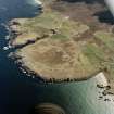
On-line Digital Images |
SC 1692890 |
RCAHMS Aerial Photography |
Oblique aerial view centred on the Smoo cave with the remains of the radar station and crofting townships adjacent, taken from the NNE. |
28/4/2004 |
Item Level |
|
 |
On-line Digital Images |
SC 1780418 |
RCAHMS Aerial Photography |
Oblique aerial view centred on the remains of the radar station with caves and crofting township adjacent, taken from the NNW. |
28/4/2004 |
Item Level |
|
 |
On-line Digital Images |
SC 1780419 |
RCAHMS Aerial Photography |
Oblique aerial view centred on the remains of the radar station with caves and crofting township adjacent, taken from the NW. |
28/4/2004 |
Item Level |
|
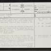 |
On-line Digital Images |
SC 2346949 |
Records of the Ordnance Survey, Southampton, Hampshire, England |
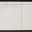
Smoo Cave, NC46NW 6, Ordnance Survey index card, page number 1, Recto |
1958 |
Item Level |
|
 |
On-line Digital Images |
SC 2346950 |
Records of the Ordnance Survey, Southampton, Hampshire, England |
Smoo Cave, NC46NW 6, Ordnance Survey index card, page number 2, Verso |
1958 |
Item Level |
|
 |
On-line Digital Images |
SC 2346951 |
Records of the Ordnance Survey, Southampton, Hampshire, England |
Smoo Cave, NC46NW 6, Ordnance Survey index card, Recto |
1958 |
Item Level |
|
 |
On-line Digital Images |
SC 2346952 |
Records of the Ordnance Survey, Southampton, Hampshire, England |
Smoo Cave, NC46NW 6, Ordnance Survey index card, Verso |
1958 |
Item Level |
|


