
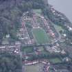
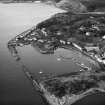
Charlestown, Harbour Road, Limekilns


Lime Kiln(S) (18th Century), Lime Works (18th Century)
Site Name Charlestown, Harbour Road, Limekilns
Classification Lime Kiln(S) (18th Century), Lime Works (18th Century)
Alternative Name(s) East Harbour Road; Charlestown, Limekilns And Associated Features
Canmore ID 49497
Site Number NT08SE 32
NGR NT 06422 83561
NGR Description Centred NT 06422 83561
Datum OSGB36 - NGR
Permalink http://canmore.org.uk/site/49497


First 100 images shown. See the Collections panel (below) for a link to all digital images.
- Council Fife
- Parish Dunfermline
- Former Region Fife
- Former District Dunfermline
- Former County Fife
NT08SE 32.00 06422 83561
NT08SE 32.01 0651 8413 Charlestown, West Quarry Limestone Quarry; Mine
For associated and adjacent (to S) Charlestown harbour, see NT08SE 31.
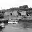
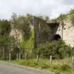
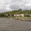
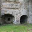
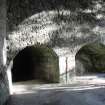
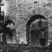
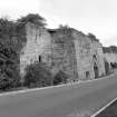
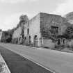
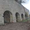
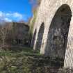
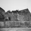
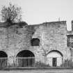
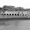
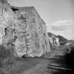
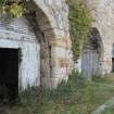
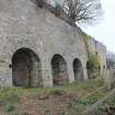
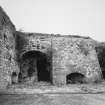
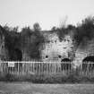
(Location cited as NT 065 835). Limekilns, built from c.1761. A long range of fourteen kilns, of some complexity, all built of dressed stone. Served by Charlestown Harbour (NT08SE 32) and the Elgin Railway (a horse-tramway), and later by a North British Rly branch (now lifted). The largest group of kilns in Scotland.
J R Hume 1976.
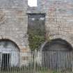
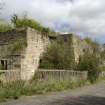
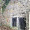
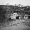
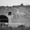
On the N side of East Harbour Road, the massive remains of limekilns, the first nine built in 1777-8, and the other five in 1792.
J Gifford 1988.
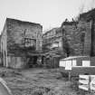
NT 064 835 Prior to the construction of an interpretation centre in the area of the E kilnhead, an archaeological watching brief was carried out by Scotia Archaeology Ltd during the machine removal of overburden. Elements of two buildings constructed of concrete, lime blocks and bricks, and eight separate concrete plinths were uncovered. All of these structures are thought to be of early 20th-century date and to have been associated with a limestone-crushing plant installed within the limits of the easternmost kilns.
Sponsor: Broomhall Estate.
R Murdoch 1996
Site recorded by Maritime Fife during the Coastal Assessment Survey for Historic Scotland, Kincardine to Fife Ness 1996
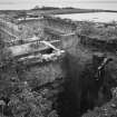
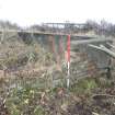
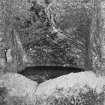
NT 063 835 Three exploratory trenches were excavated by Scotia Archaeology Ltd in advance of the proposed construction of a stair and lift for visitor access between the two levels of the site. The trenches were located in the angle between the E end of the line of kilns and the base of the retaining wall to its rear.
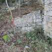
The fragmentary remains of masonry and brick walls near to the retaining wall were probably associated with the building whose roof raggles are still visible in its S face. Part of the concrete floor of this building was also revealed. To the immediate E of the kilns were two narrow brick walls, aligned N-S and barely 1m apart, with a connecting wall at their S ends. Piercing the S wall of this structure was a cast-iron pipe, anchored by a pad of concrete which extended beyond the trench edge. All of the excavated features were probably associated with the crushing plant built over the four easternmost kilns earlier this century.
Limited trenching at the W end of the site failed to confirm whether there was a flight of steps connecting the upper and lower levels of the works.
Sponsor: Broomhall Estate.
R Murdoch 1997
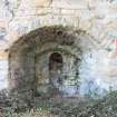
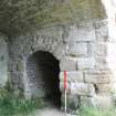
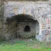
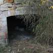
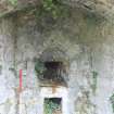
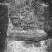
NT 066 835 Excavation to the front (S) of Kiln 11 (numbered from the E) was undertaken following the consolidation of the kiln's masonry and as part of a programme to display the kiln to the public. Kiln 11 is thought to date from the 19th century when four kilns were added to those built a century earlier.
Initially, two exploratory trenches were excavated to assess the nature and depth of the materials deposited since the limeworks was abandoned in 1957 (NMRS NT08SE 32). The main excavation was carried out over an area measuring roughly 10-15 x 10-12m. Below modern debris and kiln waste were several features of interest. These included two rows of three concrete plinths which, together with large beam sockets in the kiln wall, are thought to be elements of a structure once set against the front of the building. Against the faces of Kilns 11 and 12 were the decayed remains of numerous timber sleepers, remnants of the light railways that carried the processed lime away. At the S end of the trench was a crude metalled surface of hard-packed limestone rubble which once had probably extended over a much wider area.
Sponsor: Scottish Lime Centre.
J Lewis 2000.
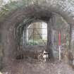
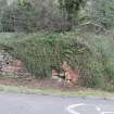
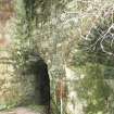
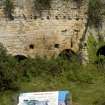
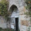
These kilns are open to easy public access, from the road to the S. Explanatory panels have been provided as an aid to visitor interpretation.
These kilns are depicted, but not noted, on the 1975 edition of the OS 1:10,000 map. The available map evidence (GIS AIB) indicates that the frontage of the kilns extends from NT c. 06375 83564 to Nt c. 06500 83549.
Information from RCAHMS (RJCM), 30 March 2006.
Publication Account (1987)
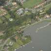
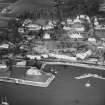
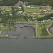
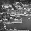
The Charlestown limekilns were part of an early industrial complex based on lime, limestone and coal production on the estate of the Earl of Elgin. The seam of limestone ran parallel to the north shore of the Firth of Forth it was from 6m to 15m thick and produced a white durable freestone capable of taking a fme polish. In the mid 18th century the 5th Earl of Elgin decided to expand his undertakings by the construction of a new harbour, new draw kilns and a tramway between the quarry and the kilns.
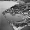
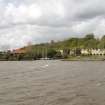
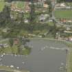
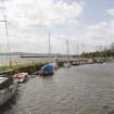
Charles town harbour was the fIrst area to be considered and the existing inner basin was constructed about 1770. The outer basin was added later, the north-west pier from about 1840 and the south-east pier at the end of the 19th century. The harbour was an immediate success and by the early 1790s it was handling 1,300 separate cargoes of manufactured lime in addition to its coal and freestone cargoes.
The Charlestown limekilns were the largest group of limekilns in Scotland and played an important role in the agricultural improvements of the 18th and 19th centuries in providing lime for the improvement of the soil and for the construction of new farm buildings.
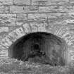
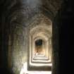
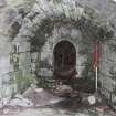
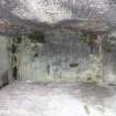
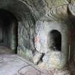
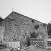
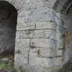
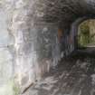
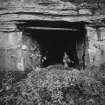
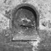
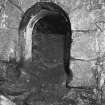
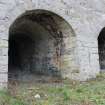
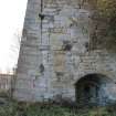
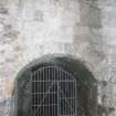
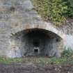
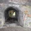
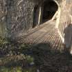
The present range of kilns date from 1777 and 1778 when construction work was started on 9 of the 14 kilns. The limestone was carried to the kilns on a horse-drawn tramway known as the Elgin Railway. This was later replaced by a branch line of the North British Railway which has now been lifted. Of the original kilns, all but the three at the east end of the range have been refaced. They are all draw kilns and constructed of dressed ashlar.
Information from ‘Exploring Scotland’s Heritage: Fife and Tayside’, (1987).
Project (2007)
This project was undertaken to input site information listed in 'Civil engineering heritage: Scotland - Lowlands and Borders' by R Paxton and J Shipway, 2007.
Publication Account (2007)
From 1757 to 1761, as the Industrial and Agricultural Revolutions gathered momentum, the 5th Earl of Elgin developed lime production on his Broomhall Estate by quarrying limestone and building kilns, the village of Charlestown, and its harbour. Prior to this, limestone deposits had been exploited at nearby Limekilns but in a small way. The present pier there seems to be of third quarter18th century construction with roughly squared dry (unmortared) sandstone block facings quarried nearby.
From 1774, with the opening of the original Elgin Wagonway, Charlestown was supplied with coal for lime making via Limekilns, the exporting port for coal from pits west of Dunfermline. In 1799 this wagonway was extended along the shore to Charlestown Harbour, being replaced by 1820 with a more direct line to the west with an inclined plane down to the harbour, including a substantial three-span arch bridge. The rails, at first of wood, were replaced by cast-iron in ca.1804 and malleable iron from ca.1820.
The imposing bank of draw kilns fronting the inner basin of the harbour were more or less continuously developed from 1759–90. The sickle-shaped in plan pier enclosing this basin is of similar construction to Limekilns Pier butwith some large blocks at the west end. Its top contains numerous mooring rings and is partly surfaced with old railway chair blocks. The inner basin entrance is 120 ft wide with an enclosed area 635 ft long by 100 ft to 180 ft wide, with a depth at Spring tides of 1612 ft in 1844.
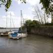
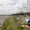
From ca.1813–34, as the Estate was becoming one of the largest industrial operations of its kind in Scotland, the 7th Earl engaged Charles Landale, civil engineer, to superintend work. In addition to maintaining the harbours, Landale introduced numerous improvements for transporting materials in, or to and from, the quarries and mines, including the inclined plane to the harbour and the ingenious inclined planes at Pittencrieff and Colton near Dunfermline. His salary was £250 per annum, plus expenses and the use of a horse! The outer basin was added later, the north-west pier dating from ca.1840 and the south-east pier after 1853. In 1859 the harbour became the property of the North British Railway Company, who provided a passenger service to Charlestown in 1894. The harbour now contains about 10 ft of mud and is unused apart from small sailing boats.
R Paxton and J Shipway 2007
Reproduced from 'Civil Engineering heritage: Scotland - Lowlands and Borders' with kind permission from Thomas Telford Publishers.
Archaeological Evaluation (16 November 2015 - 8 December 2015)
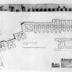
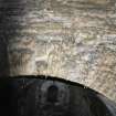
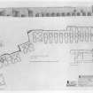
AOC Archaeology Group was commissioned by Historic Environment Scotland (HES) to undertake an exterior measured survey and an archaeological evaluation at the site of the ruined Charlestown Limekilns, Charlestown, Fife, to create a basic understanding of the remains as part of a wider scope of any future conservation works. These works were undertaken in November - December 2015. AOC were then further commissioned to undertake an interior survey of the kilns to complete the record, and these works were undertaken in July 2016.
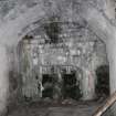
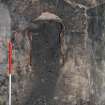
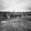
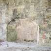
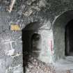
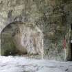
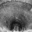
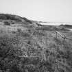
The limekilns were once part of a much wider operation dating as far back as the late 18th century to become one of the largest limeworks in the country by the 19th century. They now survive as ruins, albeit largely accessible, consisting of an array of 14 stone-built limekilns facing the harbour at Charlestown. The measured survey, undertaken using a Faro 3D laser scanner, has created 2D exterior plans, elevations and sections of the limekilns as well as some rendered orthographic images of the meshed laser scan data to display the results of the survey in a more accessible way. The suvey identified a number of features associated with how the limekilns would have originally been laid out and worked, including blocked drawholes, voids in the stonework, fixtures attached to the walls, earlier layers of render and roof scars. A topographic survey of the kilnhead was also undertaken to identify what remained of any features in this area. Although very heavily overgrown - especially to the north side - various mounds, enclosures and platforms were located, together with evidence showing the tops of some of the kiln shafts to the west side, although many were filled-in in the 1950s.
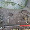
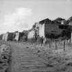
In addition to the exterior measured survey, three archaeological trenches were excavated in front of the limekilns and adjacent to Harbour Road which revealed a limited number of features relating to the operation of the limekilns during the 19th and 20th centuries. Several deposits of crushed quiklime were exposed which appeared to form a series of floors or hard standing. In addition, two concrete sleeper settings were identified associated with the rail transportation of the lime from the kiln openings to the docks. A brick and concrete foundation was also recorded to the east side of the limekilns, which are either the probable remains of the coke kilns shown on the Ordnance Survey map of 1856 or the brick buildings shown on the later Ordnance Survey map of 1896. No small finds relating to the workings of the limekilns were found.
The results of these on site works have been combined with some detailed archive research on the history of the limekilns to place the findings in context and to create a discussion on the interpretation of the features identified.
Information from AOC Archaeology Group
OASIS ID: aocarcha1-234160
Note (September 2017)
Old money, new enterprises and the building of 18th and 19th century Scotland
As you approach Charlestown limekilns, you spy a masonry structure of impressive scale and quality. But it is not a fine house nor a temple to textile wealth, but part of an 18th century industrial complex begun in the late 1750s to maximise the limestone, lime and coal production of the local landowner of the time, Charles Bruce, the 5th Earl of Elgin after whom the village and lime kilns are named. The limekilns at Charlestown were once the largest in Scotland and may arguably have been part of one of the biggest complexes of its kind in the UK. It produced one of the most important commodities of the 18th and 19th centuries in Scotland - lime.
Lime has been used in the construction of buildings, bridges and cities for millennia. From the 18th century lime was widely used by farmers as a soil improver. There was also building boom due to, amongst other things, the Act of Union (1707) which meant that there was an increase in demand throughout the 18th century for lime to make mortar (a mix of lime, water and an aggregate) and plaster (interior wall covering made of pure or 'fat' lime, sand, hair and water).
The 5th Earl's industrial complex also included a harbour (inner harbour built 1770, the pier in the last quarter of the 18th century and the outer basin piers added in the 1840s and 1850s) from which ships carried lime from the kilns, limestone for building and conversion to lime elsewhere and coal from the Elgin's Broomhill Estate coal mines to its customers. An extensive horse-drawn tramway (from 1774 on) was built between the limestone quarries, collieries and the limekilns. The Elgin Railway, as it was called, eventually became part of the national railway network. The village of Charlestown was also created to house the workers. This was a massively expensive undertaking and a financial risk that the 5th Earl was obviously willing to take to ensure the success and continuation of his Estate. By the early 1790s the manufactured lime cargoes from Charlestown reached 1300 per year. Coal and limestone shipments were also leaving from the harbour. From the late 18th to the mid- 19th centuries, most of the lime from Charlestown was exported to North East Scotland, Stirling area and the Lothians but rarely to the West of the country. Export to other countries like Sweden and Canada was not unknown.
From about 1815 until the mid 1830s, Charlestown became extremely successful with the 7th Earl making commissioning further engineering work to improve the harbour and the quarrying and mining infrastructure.
The Kilns, Making Lime and Finis
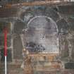
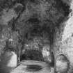
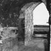
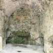
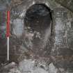
The Charlestown kilns (1759/60 - 1790 and possibly later work) were built into the cliff face to enable the creation of a charging platform from which the kilns could easily be filled or charged with coal and limestone. There are 14 draw kilns with vaulted entrances which when in operation would have burnt continuously during the lime-burning season (March - November). Ten of the kilns have been refaced with a masonry skin or buttress built up against the wall to strengthen the structure possibly because the heat produced during burning may have weakened the masonry. At the east end, a now demolished 20th century stone crushing plant was added.
It is in these kilns that lime was produced. Lime is made by burning layered locally quarried limestone and coal in the kiln to produce a dry material known as 'quicklime' or calcium oxide. Water is added to the quicklime in a controlled process known as 'slaking'. It is this process that produces lime for building works. Un-slaked lime - quicklime - was used as a soil improver.
The lime made at Charlestown had a particular quality resulting from the local limestone. Limestone with a sufficient clay or silica content produces a lime that is 'hydraulic' meaning that it sets under water. Charlestown limestone was sent to Leith Wet Docks (1814) and Dundee Docks (1833) where it was burnt produce quicklime for making mortar on site.
The kilns and quarry were in use until 1935, with parts of the limeworks complex being demolished in the 1960s. The kilns are Category A Listed.
Miriam R McDonald - Industrial Survey, Historic Environment Scotland
Watching Brief (23 July 2018 - 16 August 2018)
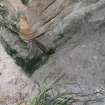
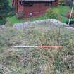
NT 06422 83561 A watching brief was undertaken, 23 – 27 July 2018, on landscaping works within the scheduled monument (SM 3734). Archaeological remains were uncovered on the site, consisting of brick and stone surfaces, and after detailed recording of the features it was agreed with the contractors and HES that the paths would either be moved or the archaeology covered over and protected.
Archive: NRHE (intended). Report: Fife HER
Funder: Historic Environment Scotland
Bethan Gray – CFA Archaeology Ltd
(Source: DES Vol 19)
OASIS ID: cfaarcha1-325952

