
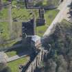
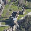
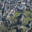
Dunfermline, St Margaret's Street, Dunfermline Abbey, Entrance Gateways And Precinct Wall


Gateway (14th Century), Wall (14th Century)
Site Name Dunfermline, St Margaret's Street, Dunfermline Abbey, Entrance Gateways And Precinct Wall
Classification Gateway (14th Century), Wall (14th Century)
Canmore ID 49316
Site Number NT08NE 1.01
NGR NT 09069 87289
NGR Description NT c.0907 8730
Datum OSGB36 - NGR
Permalink http://canmore.org.uk/site/49316


- Council Fife
- Parish Dunfermline
- Former Region Fife
- Former District Dunfermline
- Former County Fife
NT08NE 1.01 c. 0907 8730
Abbey Park Wall (NR)
OS 6"map, Fifeshire, 1st ed., (1854)
Precinct Wall of Dunfermline Abbey: At the beginning of the 14th century the Abbey property was surrounded by a wall of about 3,000' in circumference, 12' high and 4' - 5' thick, with ports and posterns.
J R Walker 1891.
Remains of the Abbey Wall to the south are still to be seen at the head of the glebe and at the manse gate, where there is also still visible one of the side piers with the spring stone of an archway (South Port - NT08NE 1.3) which crossed the street. A part of the east wall still remains in a garden between Priory Lane and Canmore Street.
P Chalmers 1844-59.
Webster's map of 16th c Dunfermline shows a portion of wall from P through approximately NT 0909 8720 to F (ie. the South Port)
J M Webster 1953.
A - B NT 0906 8736 - NT 0930 8732 Site of Abbey Park Wall (OS 6"map, 1854)
B - C NT 0930 8732 - NT 0931 8715 Site of Abbey Park Wall (OS 6"map, 1854) "75 feet of abbey wall remains" and part shown as still extant from A for c.45m. (P Chalmers 1859)
C - D NT 0931 8715 - NT 0931 8713 Abbey Park Wall (OS 6"map, 1854) 50 feet remains (J M Webster 1953)
D - E NT 0931 8713 - NT 0932 8710 Site of Abbey Park Wall (OS 6"map, 1854; P Chalmers 1859)
E - F NT 0932 8710 - NT 0909 8710 Site of Abbey Park Wall (OS 6"map, 1854) 430' of abbey wall running due west from E still remains (OS 6"map, 1854)
F - G NT 0909 8710 - NT 0902 8714 Palace Wall (OS 6"map, 1854) Abbey Wall shown as extant through G or c. 10m S of it to H (P Chalmers 1859) G - H NT 0902 8714 - NT 0895 8719 Site of Palace Wall (OS 6"map, 1854)
J - K NT 0893 8731 - NT 0894 8737 Abbey Wall shown as extant (P Chalmers 1859).
L - M NT 0895 8724 - NT 0902 8720 Abbey Wall shown as extant (P Chalmers 1859).
N - P NT 0901 8723 - NT 0905 8721 Site of the Abbey Park Wall (OS 6"map, 1854)
The only portions of the wall remaining area:
NT 0917 8735 - NT 0919 8735 (renovated): NT 0908 8710 - NT 0906 8710: and NT 0905 8711 - NT 0897 8720 (renovated).
No further information.
Visited by OS (D W R) 18 February 1974.
Trial excavation by Scottish Urban Archaeological Trust in January 1993 at NT 0931 8719 revealed this wall, running N-S 0.5m below the modern ground surface. (See NT08NE 112 and NT08NE 116 for further details of trial excavations and watching brief in 1994.)
Information from Mr D Bowler, SUAT, March 1993.
R Coleman 1993.
Scheduled lengths:
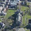
(9276). 'stretch of abbey precinct wall on Canmore Street... a stretch of substantial rubble-built masonry walling... to the NE of the Benedictine abbey church, and thought to be a part of the N wall of the abbey precinct.'
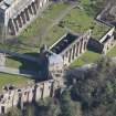
(9279). 'remains in Pittencrieff Glen to NW of Abbey chirch... dog-legged section of medieval wall of carefully constructed masonry rising from a double-chamfered plinth course and supported by five buttresses. The wall is pierced by two levels of rectangular windows with chamfered surrounds, now mostly blocked.'
Information from Historic Scotland, scheduling documents dated 23 february 2001.

