
Weston


Henge (Neolithic) - (Bronze Age)
Site Name Weston
Classification Henge (Neolithic) - (Bronze Age)
Alternative Name(s) Whitewellbrae Wood
Canmore ID 48914
Site Number NT04NW 9
NGR NT 0300 4578
Datum OSGB36 - NGR
Permalink http://canmore.org.uk/site/48914


- Council South Lanarkshire
- Parish Carnwath
- Former Region Strathclyde
- Former District Clydesdale
- Former County Lanarkshire
Field Visit (25 June 1943 - 27 June 1943)
Enclosure, Newbigging.
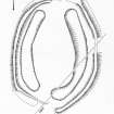
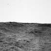
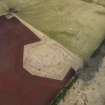
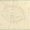
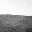
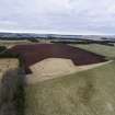
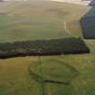
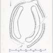
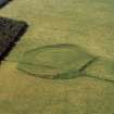
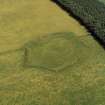
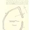
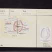
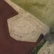
This monument stand prominently on an underfeature one mile E of Newbigging, and about 800ft above sea-level. It commands a wide view over the valley of the South Medwin, which runs past about half a mile away towards the SE. It consists of an almond shaped enclosure (see plan) measuring internally 302 ft from NE to SW – the pointed end being towards the NE – by 200ft from NW to SE. The rampart is made of earth and stones and is everywhere overgrown with grass; it varies in breadth, where undamaged, from 14ft to 26ft and stands to a maximum height of 7ft above the level of the ground outside – this on the SE sector – and from 2ft to 4ft above that interior. There are two large gaps in the rampart, one, in the E sector being 35ft wide, and the other, in the SSW, about 60ft wide; the latter is almost certainly due to the ploughing-out of the rampart, and the former also appears to have been made for agricultural purposes. There is also a small gap, only 8ft wide in the SW sector; a large stone appears in the S side of this gap, but there is no definite evidence that it was an entrance. There is no trace of ditch anywhere. In the SW part of the interior, approximately on the major axis, there is a stony patch of ground some 15ft in diameter which may represent the foundations of a hut.
The interior has all been cultivated, but in two separate divisions – a central ‘island’ and a belt from 25ft to 40ft wide which runs round inside the rampart and in places impinges upon it. This belt appears quite clearly in the section given with the sketch-plan. On the NW sector, where it is 25ft wide, it appears to occupy an artificial hollow about 2ft deep on the outer NW side of which there appears a face of rock, apparently cut artificially to form a step. On top of this there is a berm 9ft wide extending to the base of the rampart. In view of the absence of any ditch, it seems possible that the material of the rampart was obtained by means of shallow excavation and quarrying in a zone running round the interior of the enclosure, and that the existence of the hollow so formed determined the disposition of ploughing in later times.
Visited by RCAHMS (AG) 25 July 1943
Sketch plan in MS, p61, based on compass traverse in notebook MS 124/3, p94.
OS map ref: xxvii NW (‘Earthwork’)
Measured Survey (25 August 1959)
RCAHMS surveyed this site by plane-table on 25 August 1959. The resultant plan was redrawn in ink in 1974 and published at a reduced size in RCAHMS 1978 as Figure 32.
Field Visit (8 July 1971)
NT04NW 9 0300 4578.
(NT 0300 4578) Henge (NR)
OS 25" map (1973)
This henge was in a similar condition (cf. RCAHMS 1978) when seen in 1971.
Surveyed at 1:2500.
Visited by OS (DWR) 8 July 1971
Field Visit (August 1974)
NT04NW 030 457
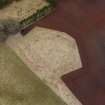
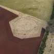
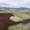
This henge, situated in an arable field 1.8km SSW of Weston farmhouse and at a height of 255m OD, commands a wide view over the South Medwin, which flows past about 850m to the SE. The site has been considerably damaged by cultivation, but the chief characteristics of a Class II henge - a surrounding bank with internal ditch and two opposing entrances - can still be distinguished.
Oval on plan, the henge measures 91m by 66m from crest to crest of the bank, with the longer side aligned about 10deg E of N. Along each side the bank is reasonably well preserved, standing at least 1.8m in height externally and 0.9m internally. Except on the E side of the S entrance, the ends of the bank have, however, been reduced and distorted by the plough. The ditch measures 10.7m in average width and up to 0.5m in depth.
RCAHMS 1978, visited August 1974

