 |
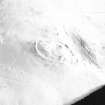
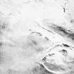
On-line Digital Images |
SC 573012 |
RCAHMS Aerial Photography |
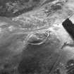
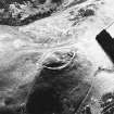
Snaip Hill, oblique aerial view, taken from the N, centred on the remains of fort, with an enclosure and possible hut circle to the left of the photograph. |
|
Item Level |
|
 |
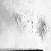
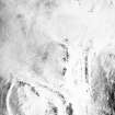
On-line Digital Images |
SC 573013 |
RCAHMS Aerial Photography |
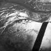
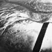
Oblique aerial view. |
1980 |
Item Level |
|
 |
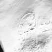
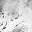
On-line Digital Images |
SC 573014 |
RCAHMS Aerial Photography |
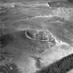
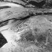
Snaip Hill, oblique aerial view, taken from the W, centred on the remains of fort, enclosure and possible hut circle. |
|
Item Level |
|
 |
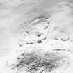
On-line Digital Images |
SC 573015 |
RCAHMS Aerial Photography |
Oblique aerial view. |
1991 |
Item Level |
|
 |
On-line Digital Images |
SC 1730415 |
RCAHMS Aerial Photography |
Oblique aerial view. |
1991 |
Item Level |
|
 |
On-line Digital Images |
SC 1730416 |
RCAHMS Aerial Photography |
Oblique aerial view. |
1991 |
Item Level |
|
 |
On-line Digital Images |
SC 1730417 |
RCAHMS Aerial Photography |
Oblique aerial view. |
1991 |
Item Level |
|
 |
On-line Digital Images |
SC 1730418 |
RCAHMS Aerial Photography |
Oblique aerial view. |
1991 |
Item Level |
|
 |
On-line Digital Images |
SC 1730419 |
RCAHMS Aerial Photography |
Oblique aerial view. |
1991 |
Item Level |
|
 |
On-line Digital Images |
SC 1730420 |
RCAHMS Aerial Photography |
Oblique aerial view. |
1991 |
Item Level |
|
 |
On-line Digital Images |
SC 1730421 |
RCAHMS Aerial Photography |
Oblique aerial view. |
1991 |
Item Level |
|
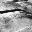 |
On-line Digital Images |
SC 1730461 |
RCAHMS Aerial Photography |
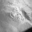
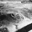
Snaip Hill, oblique aerial view, taken from the NE, centred on the remains of fort, with an enclosure and possible hut circle. |
22/2/1996 |
Item Level |
|
 |
On-line Digital Images |
SC 1730462 |
RCAHMS Aerial Photography |
Snaip Hill, oblique aerial view, taken from the N, centred on the remains of fort, with an enclosure and possible hut circle to the left of the photograph. |
22/2/1996 |
Item Level |
|
 |
On-line Digital Images |
SC 1730463 |
RCAHMS Aerial Photography |
Snaip Hill, oblique aerial view, taken from the W, centred on the remains of fort, enclosure and possible hut circle. |
22/2/1996 |
Item Level |
|
 |
On-line Digital Images |
SC 1730464 |
RCAHMS Aerial Photography |
Snaip Hill, oblique aerial view, taken from the S, centred on the remains of fort, with an enclosure and possible hut circle to the right of the photograph. |
22/2/1996 |
Item Level |
|
 |
On-line Digital Images |
SC 1730522 |
RCAHMS Aerial Photography |
Oblique aerial view. |
1980 |
Item Level |
|
 |
On-line Digital Images |
SC 2436397 |
Records of the Ordnance Survey, Southampton, Hampshire, England |
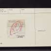
Snaip Hill, NT03SW 44, Ordnance Survey index card, page number 1, Recto |
1958 |
Item Level |
|
 |
On-line Digital Images |
SC 2436398 |
Records of the Ordnance Survey, Southampton, Hampshire, England |
Snaip Hill, NT03SW 44, Ordnance Survey index card, page number 2, Verso |
1958 |
Item Level |
|
 |
On-line Digital Images |
SC 2436399 |
Records of the Ordnance Survey, Southampton, Hampshire, England |
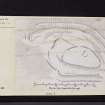
Snaip Hill, NT03SW 44, Ordnance Survey index card, Recto |
1958 |
Item Level |
|
 |
On-line Digital Images |
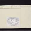
SC 2436400 |
Records of the Ordnance Survey, Southampton, Hampshire, England |
Snaip Hill, NT03SW 44, Ordnance Survey index card, Recto |
1958 |
Item Level |
|
 |
On-line Digital Images |
SC 2436401 |
Records of the Ordnance Survey, Southampton, Hampshire, England |
Snaip Hill, NT03SW 44, Ordnance Survey index card, Recto |
1958 |
Item Level |
|
 |
On-line Digital Images |
SC 2436402 |
Records of the Ordnance Survey, Southampton, Hampshire, England |
Snaip Hill, NT03SW 44, Ordnance Survey index card, Verso |
1958 |
Item Level |
|


