
Beattock Hill


Field System(S) (Prehistoric), Pen(S) (Post Medieval), Ring Ditch House (Prehistoric), Settlement (Iron Age)
Site Name Beattock Hill
Classification Field System(S) (Prehistoric), Pen(S) (Post Medieval), Ring Ditch House (Prehistoric), Settlement (Iron Age)
Alternative Name(s) Stanshiel Rig
Canmore ID 48429
Site Number NT00SE 7
NGR NT 057 016
Datum OSGB36 - NGR
Permalink http://canmore.org.uk/site/48429


- Council Dumfries And Galloway
- Parish Kirkpatrick-juxta
- Former Region Dumfries And Galloway
- Former District Annandale And Eskdale
- Former County Dumfries-shire
NT00SE 7.00 0569 0182
See also NT00SE 8 and NT00SE 101.
NT00SE 7.01 05 01 Field-systems
NT00SE 7.02 0569 0182 Settlement
NT00SE 7.03 0557 0157 and 0558 0158 Hut-circles
NT00SE 7.04 0560 0165 Ring-ditch House
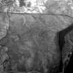
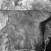
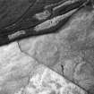
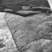
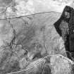
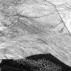
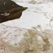
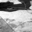
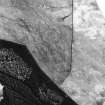
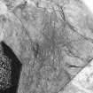
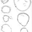
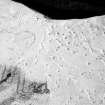
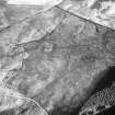
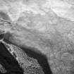
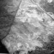
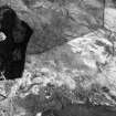
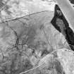
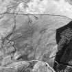
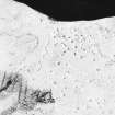
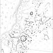
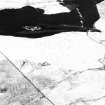
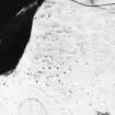
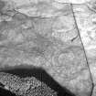
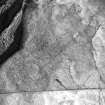
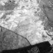
NT 057 018. A small walled homestead, of a type locally datable to the 2nd-4th centuries AD, lies at Stanshiel Rig, about 1/2mile WSW of the summit of Beattock Hill. Lying within an area of cultivation 26.3 ha in extent (which doubtless includes the "cairnfield" noted by Scott-Elliott at NT 054019) (J Scott-Elliot 1967) , it measures some 80 ft N-S by 59 ft within a stone wall, 6 ft thick ('C' on plan showing a sample area of 7.3 ha). Also in this sample area are the sites of timber buildings (A, B) indicated by an annular ditch and by shallow, circular depressions, and a walled enclosure (NT00SE 8 qv). There are irregular small plots defined by lynchets and banks along which clearance cairns are placed, and there are also longer, straighter lynchets and banks, two sets of which form roadways. The roadways lead towards a space among the plots and fields which, if not occupied by enclosure D would recall the open spaces at the focal points of roads which, in southern England, probably indicate Roman influence. Thus the impression given by the remains illustrated is that such part of the system incorporating long lynchets as can be distinguished overlies and has partly obliterated an older system of small, irregular plots. The latter could be assoicated with the timber buildings A and B, while homestead C could, though need not, belong to the field system. Nothing was found when some of the cairns were excavated in 1911 by A H Bishop (RCAHMS 1920).
R W Feachem 1973
NT 0569 0182. A homestead situated in a sheltered hollow on a south east-facing hillslope. It is 23.0m N-S by 14.0m within a turf-covered rubble wall 3.2m wide and up to 0.6m high. There is a 2.6m wide entrance in the east. In the interior on the west side a circular hut foundation abuts the homestead wall. It is sub-circular, 7-5m in diameter, within turf-covered walling 1.2m wide and up to 0.7m high. There is a 1.6m wide entrance in the east. To the south and east of the homestead is an extensive field system occupying about 11.5 hectares. It has numerous clearance cairns, lynchets and evidence of both long and short fields, as described, indicating both hoe and plough cultivation. Stretches of a 4.5m trackway can be seen approaching from the west and north- east. Vague shallow depressions are all that can be seen at the suggested hut sites.
(Homestead surveyed at 1:10 000).
Visited by OS (T R G) 24 September 1978)
Field Visit (October 1990)
NT00SE 7.00 0569 0182
A small field-system occupies a ridge on the SW flank of Beattock Hill. The W edge is defined by a steep natural slope (including vertical rock-faces) the top of which has been planted with conifers; the S and E margins are marked by boggy ground, while on the N, close to the modern track which defines the N edge of the survey area, the ground is uneven and rocky. A thin spread of small cairns is visible between the track and another group of small cairns (NT00SE 33) which lies about 200m to the NE.
Visited by RCAHMS (JRS), 9 October 1990.
Listed as 'Stanshiel Rig, cairnfield and lynchets'.
RCAHMS 1997.

