 |
On-line Digital Images |
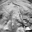
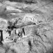
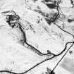
SC 379154 |
|
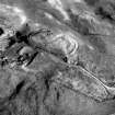
Aerial view. |
|
Item Level |
|
 |
On-line Digital Images |
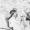
SC 381967 |
Records of the Royal Commission on the Ancient and Historical Monuments of Scotland (RCAHMS), Edinbu |
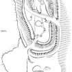
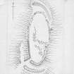
Publication drawing; Plan of Beattock Hill fort and adjacent unenclosed settlement. |
1996 |
Item Level |
|
 |
On-line Digital Images |
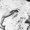
SC 1346391 |
Records of the Royal Commission on the Ancient and Historical Monuments of Scotland (RCAHMS), Edinbu |
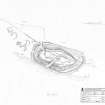
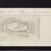
Survey drawing; Plan of Beattock Hill fort |
23/10/1990 |
Item Level |
|
 |
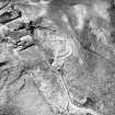
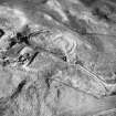
On-line Digital Images |
SC 1729556 |
RCAHMS Aerial Photography |
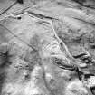
Aerial view. |
1988 |
Item Level |
|
 |
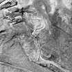
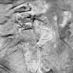
On-line Digital Images |
SC 1729557 |
RCAHMS Aerial Photography |
Aerial view. |
1988 |
Item Level |
|
 |
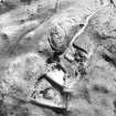
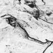
On-line Digital Images |
SC 1729558 |
RCAHMS Aerial Photography |
Aerial view. |
1988 |
Item Level |
|
 |
On-line Digital Images |
SC 1729559 |
RCAHMS Aerial Photography |
Aerial view. |
1988 |
Item Level |
|
 |
On-line Digital Images |
SC 1729560 |
RCAHMS Aerial Photography |
Aerial view. |
1988 |
Item Level |
|
 |
On-line Digital Images |
SC 1729561 |
RCAHMS Aerial Photography |
Aerial view. |
1988 |
Item Level |
|
 |
On-line Digital Images |
SC 1729562 |
RCAHMS Aerial Photography |
Aerial view. |
1988 |
Item Level |
|
 |
On-line Digital Images |
SC 1729563 |
RCAHMS Aerial Photography |
Aerial view. |
1988 |
Item Level |
|
 |
On-line Digital Images |
SC 1729564 |
RCAHMS Aerial Photography |
Aerial view. |
1988 |
Item Level |
|
 |
On-line Digital Images |
SC 1729635 |
RCAHMS Aerial Photography |
Aerial view. |
1991 |
Item Level |
|
 |
On-line Digital Images |
SC 1729636 |
RCAHMS Aerial Photography |
Aerial view. |
1991 |
Item Level |
|
 |
On-line Digital Images |
SC 1729637 |
RCAHMS Aerial Photography |
Aerial view. |
1991 |
Item Level |
|
 |
On-line Digital Images |
SC 1729638 |
RCAHMS Aerial Photography |
Aerial view. |
1991 |
Item Level |
|
 |
On-line Digital Images |
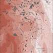
DP 315123 |
Records of the Royal Commission on the Ancient and Historical Monuments of Scotland (RCAHMS), Edinbu |
Upper Annandale landscape case-study area: map showing the monuments of the prehistoric and Roman landscape against the extent of forestry and modern cultivated land. Published in Eastern Dumfriesshire: an archaeological landscape. |
1996 |
Item Level |
|
 |
On-line Digital Images |
DP 380541 |
Records of the Royal Commission on the Ancient and Historical Monuments of Scotland (RCAHMS), Edinbu |
Plan of Fort, Inv. no,401, fig. 96. RCAHMS 1912 1":40' |
1912 |
Item Level |
|
 |
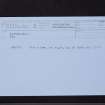
On-line Digital Images |
SC 2435395 |
Records of the Ordnance Survey, Southampton, Hampshire, England |
Beattock Hill, NT00SE 5, Ordnance Survey index card, page number 1, Recto |
1958 |
Item Level |
|
 |
On-line Digital Images |
SC 2435396 |
Records of the Ordnance Survey, Southampton, Hampshire, England |
Beattock Hill, NT00SE 5, Ordnance Survey index card, page number 2, Verso |
1958 |
Item Level |
|
 |
On-line Digital Images |
SC 2435397 |
Records of the Ordnance Survey, Southampton, Hampshire, England |
Beattock Hill, NT00SE 5, Ordnance Survey index card, Recto |
1958 |
Item Level |
|
 |
On-line Digital Images |
SC 2435398 |
Records of the Ordnance Survey, Southampton, Hampshire, England |
Beattock Hill, NT00SE 5, Ordnance Survey index card, Recto |
1958 |
Item Level |
|
 |
On-line Digital Images |
SC 2435399 |
Records of the Ordnance Survey, Southampton, Hampshire, England |
Beattock Hill, NT00SE 5, Ordnance Survey index card, Recto |
1958 |
Item Level |
|


