
Auldton Mote


Motte And Bailey (Medieval), Rig And Furrow (Medieval) - (Post Medieval)
Site Name Auldton Mote
Classification Motte And Bailey (Medieval), Rig And Furrow (Medieval) - (Post Medieval)
Alternative Name(s) Alton; Moffat Motte; Birnock Water; Auldton Motte
Canmore ID 48331
Site Number NT00NE 14
NGR NT 0938 0583
Datum OSGB36 - NGR
Permalink http://canmore.org.uk/site/48331


- Council Dumfries And Galloway
- Parish Moffat
- Former Region Dumfries And Galloway
- Former District Annandale And Eskdale
- Former County Dumfries-shire
NT00NE 14 0938 0583
(NT 0938 0583) Auldton Mote (NR)
OS 6" map, (1957)
The mote and base court at Auldton Hill strongly resembles the Saxon type.
D Christison 1891
Auldton, to the E of Moffat, the original village, has now disappeared except for some foundations.
Trans Dumf Galloway Natur Hist Antiq Soc 1924
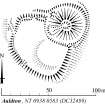
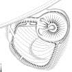
Auldton Mote (name confirmed), a motte and bailey, is situated on a slight knoll overlooking Birnock Water. It measures c. 36.0m in diameter and c. 6.0m high. The summit is 10.0m diameter but has been hollowed out by quarrying. The bailey measures 73.0m NW - SE by 36.0m transversely and is defined by a scarp except in the N where the bank and ditch still survive.
There are no indications that a village was situated nearby.
Surveyed at 1:2500.
Visited by OS (D W R) 20 January 1972.
NT 093 058 Excavation for a septic tank, 35m W of the bailey boundary of Auldton Mote, revealed fluvial gravels and silts overlying glacial gravel.
Sponsor: Dumfries and Galloway Council.
A Nicholson 2000.
[Index no. 12723]. Scheduled as 'Alton, moated site 530m ESE of...'
Information from Historic WScotland, wscheduling document dated 24 March 2010.
Auldton Mote [NAT]
OS (GIS) MasterMap, April 2010.
Measured Survey (4 July 1990)
RCAHMS surveyed the motte and bailey at Auldton Mote on 4 July 1990 with plane-table and self-reducing alidade at a scale of 1:500. The plan was redrawn in ink and published at a scale of 1:1000 (RCAHMS 1997; Fig. 204). A further inked version was produced and published at a scale of 1:2500 alongside comparative plans of mottes and medieval earthwork monuments (RCAHMS 1997, Fig. 202).
Field Visit (4 July 1990)
NT 0938 0583 NT00NE 14
This impressive motte-and-bailey castle stands beside the track to Alton on the eastern outskirts of Moffat (NT00NE 31); it stands to a height of up to 8m and has an oval summit up to 13m in diameter. The SW side of the motte has been severely damaged by a trench which has presumably been opened by an antiquarian to examine the internal structure; on the WNW side of the motte there are traces of a second trench. In each case, the earth removed from the excavation has been dumped in a heap at the foot of the motte.
The motte is enclosed by a ditch (up to 6m broad and at least 1.8m deep) and, except on the side of the bailey, by a counterscarp bank. The bailey encloses an area of raised ground on the SW with the highest part of the interior lying to the E. The enclosing earthwork is most substantial on the NNW, where it comprises a thick inner bank with an external ditch, but elsewhere it has been reduced to little more than a steep external scarp. Breaks in the scarp on the WNW and SSW are probably modern, but a gap in the bank on the NNW may mark the position of the original entrance. If so, the absence of a corresponding causeway across the ditch probably indicates the presence of a timber bridge.
The interior of the bailey bears traces of curving rig-and-furrow cultivation.
Visited by RCAHMS (IMS, PC, SH), 4 July 1990.
Listed as motte-and-bailey.
RCAHMS 1997.
Project (15 April 2019 - 9 May 2019)
Approximately 4ha of magnetometer survey and three test areas of earth electrical resistance survey totalling approximately 0.5ha were undertaken on land at Auldton Mote, Mofat, Dumfries and Galloway prior to proposed residential development.
Series of features which almost certainly represent former water courses have been identified.
Possible other soil-filled features, which could represent anthropogenic features, have also been identified, although the exact nature and origin of these remains uncertain.
Weak anomalies which almost certainly reflect natural variation in the underlying soils and geology have also been detected.
Former ploughing regimes and land drains have been detected.
Information from OASIS ID: archaeol3-350594 (R Villis) 2019
Resistivity (15 April 2019 - 9 May 2019)
Resistivity survey.
Information from OASIS ID: archaeol3-350594 (R Villis) 2019
Magnetometry (15 April 2019 - 9 May 2019)
Magnetometry survey.
Information from OASIS ID: archaeol3-350594 (R Villis) 2019
Field Visit (19 March 2019)
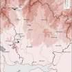
Wardell Armstrong LLP (WA) was commissioned by Mr. Brian Walker to prepare a Heritage Statement relating to the housing masterplan site at Selkirk Road in Moffat (centred on NGR NT 09547 05520) and the development's potential to impact upon Auldton Mote scheduled monument. This assesment is required to support the housing masterplan for the site. This assessment work comprised a consultation of site-specific pre-application documents and professional advice issued by Historic Environment Scotland and included a programme of targeted desk-based research incorporating the results of a site visit. It aims to show the impact on the heritage significance of heritage assets with the potential to be affected by the proposed scheme, primarily Audton Mote, which is located within the northern part of the masterplan site boundary. The potential for encountering sub-surface archaeological remains, and mitigative work associated with this potential, has been addressed separately by a programme of trial trench evaluation and is not considered here.
The masterplan site lies to the east of the historic centre of Moffat, to the north of Selkirk Road and Moffat Hospital, and east of Ballplay Road, occupying land either side of the Crosslaw Burn, an area of potential earlier occupation. Auldton Mote, within the northern part of the masterplan site, is a scheduled monument of national significance. a further four scheduled sites are concentrated along Frenchland Burn, which runs 500m to the east of the site, and to the west of the centre of the site is a fifth scheduled monumnet, all of which have potential visual relationships, and therefore have associations with Auldton Mote. An additional six areas of archaeological interest have been identified in the vicinity.
The assessment has identified that no heritage assets will be directly impacted by a development within the masterplan area, through indirect impacts will occur. The area has already been indirectly affected by the eastern expansion of Moffat in the 19th and 20th centuries. This expansion has had a limited impact on the setting of the monuments. For Auldton Mote, the housing development and its effects on intervisibility with other heritage assets in the vicinity, would result in a 'limited impact' on heritage significance. This impact has been partly addressed through design, and partly offset by the positive impact of the proposed development through improving access and understanding of assets and their setting.
Information from Wardell Archaeology LLP.

