
Garlet House


House (17th Century)
Site Name Garlet House
Classification House (17th Century)
Alternative Name(s) The Garlet
Canmore ID 48314
Site Number NS99SW 20
NGR NS 92612 90115
Datum OSGB36 - NGR
Permalink http://canmore.org.uk/site/48314


- Council Clackmannan
- Parish Clackmannan
- Former Region Central
- Former District Clackmannan
- Former County Clackmannanshire
Only slight foundations remain.
Visited by OS 9 February 1973.
The Garlet is depicted on the OS 2nd Edition map (Clackmannanshire, sheet CXL, 1897). It has since been demolished.
Information from RCAHMS (HMLB), August 2002.
NS 8151 9011 Jacobs Babtie was commissioned to prepare a short report on the archaeological monitoring of selected boreholes and trial pits along the route of the Kincardine Crossing. This monitoring was designed to inform and assess on the implications of sedimentation in the alluvial deposits, primarily on the floodplain of the River Forth.
Boreholes - NS 9199 8857, NS 9214 8907, NS 9216 8931, NS 9222 8956, NS 9236 8985, NS 9255 9018.
Trial Pits - NS 9201 8857, NS 9209 8889, NS 9226 8895, NS 9224 8959, NS 9232 8981, NS 9250 9010.
Monitoring of the coring and the boreholes revealed a similar sequence of stratified deposits across the route of the Kincardine crossing where it crosses the floodplain from the north shore of the River Forth as far as the site of Gartlets House. A fairly uniform stratigraphy along the whole of the monitored section of the proposed route as far as the raised beach above the site of Gartlet was revealed during this progamme of Ground Investigation. A further aim of the fieldwork monitoring was to assess the site at Gartlet and the potential for survival of remains of the former Lairds House. It was noted during fieldwork that damaged enclosure walls survived and foundation deposits and other remains associated with the site of the former house probably survive.
Jacobs Babtie, 2005
NMRS REFERENCE:
Demolished October 1964
Field Visit (20 March 1928)
Garlet.
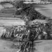
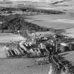
Beside some cottages a quarter of a mile east of Kilbagie Station there is a 17th-century laird's house of pleasing proportions. It is oblong on plan measuring externally 41 feet 8 inches by 19 feet 4 inches, and is two storeys and a garret high. The central portion of the front, which is set slightly forward, is corniced above the entrance and terminates in a gable. Between the two central first-floor windows is a space for a panel which has, however, been removed to Kennet House. The masonry is of rubble, harled; voids, wall-heads and quoins have dressed margins. The main gables are crow-stepped and the roof is pantiled. The entrance is a moulded doorpiece with lugged architrave. The back elevation is concealed by 'outshots.' On the west gable is a mutilated gate-pier of Renaissance design.
RCAHMS 1933, visited 20 March 1928.
Measured Survey (November 1944)
Drawings of Garlet House, Clackmannanshire, by Stanislaw Tyrowicz for the National Buildings Record Scottish Council in November 1944.
Field Visit (August 1977)
Garlet NS 926 901 NS99SW
A laird's house of 17th-century date, demolished in 1964.
RCAHMS 1978, visited August 1977
(RCAHMS 1933, p. 320, No. 609)
Archaeological Evaluation (November 2005 - February 2006)
Headland Archaeology was commissioned by Historic Scotland on behalf of the Scottish Executive to undertake an evaluation of the Upper Forth Crossing at Kincardine in advance of the construction of a new bridge and road, covering the route OS NGR NS 93261 90631 to NS 90419 85656. Phase 1 of the evaluation indicated two sites that would be affected by the proposed road scheme. The first is located at the northern end of the scheme and comprises features of Iron Age and medieval date within an area of 2.1 hectares. The second comprised the remains of a largely demolished 17th century laird’s house and buildings at Garlet. The evaluation has identified archaeological remains that pre-date the existing house and associated structures. Elsewhere within the corridor the remains of rig and furrow cultivation, of probable medieval date, were recorded on the carse areas either side of the River Forth. In addition, the possible remains of Second World War glider traps were recorded on the south side of the River.
Excavation (January 2006 - April 2006)
A programme of site investigations along the route of the New Kincardine Crossing was undertaken between November and December 2005. As mitigation, two set-piece excavations were carried out between January and April 2006.
NS 9261 9012 The first programme of excavation and building recording was undertaken at the remains of the 17th-century laird's house and associated buildings at Garlet, Kilbagie. The initial evaluation identified archaeological remains that possibly pre-dated the existing house and associated structures, which were largely demolished in the 1960s. Upon further investigation however, it was evident that significant structural remains survived below ground. The buildings survey established a number of phases relating to the main house and later extensions and buildings that make up the building complex at Garlet. Further excavation in the vicinity of the house also established the presence of surfaces and structures associated with the main house but no archaeological remains that pre-dated the 17th-century house.
NS 928 904 The second excavation was at Meadowend Farm, near Clackmannan (NS99SW 115).
Archive to be deposited in NMRS.
Sponsor: Scottish Executive
Elizabeth Jones, 2006.

