
Castle Craig


Fort (Prehistoric)(Possible), Quarry (20th Century)
Site Name Castle Craig
Classification Fort (Prehistoric)(Possible), Quarry (20th Century)
Alternative Name(s) Tillicoultry
Canmore ID 48294
Site Number NS99NW 5
NGR NS 9116 9769
Datum OSGB36 - NGR
Permalink http://canmore.org.uk/site/48294


- Council Clackmannan
- Parish Tillicoultry (Clackmannanshire)
- Former Region Central
- Former District Clackmannan
- Former County Clackmannanshire
NS99NW 5 9116 9769.
(NS 9118 9768) Fort (NR) (Site of)
OS 25"map, (1961)
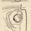
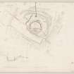
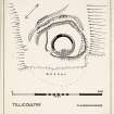
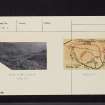
Before its destruction by quarrying (Cruden 1964) Castle Craig fort consisted of a deep rock-cut ditch with a stone wall along the inner tip and the remains of a stony rampart on the outer, cutting off an area of the tip of the promontory measuring 300' in width by at least 200', and probably originally more in length. The interior contains an exactly circular enclosure measuring 82' in diameter within the remains of a very well built stone wall 12' thick. Whether or not the two structures are contemporary cannot be decided from the surface remains which do not coincide at any point, but the probability is that the circular enclosure is an intruder, and may be of post-Roman date.
Maclagan (1875) notes 3 concentric circular walls, 35' apart, the central circle 80' in diameter, and adds that the stones have nearly all been used to build sheepfolds, the square walls of which may be traced within the circular walls.
C Maclagan 1875; RCAHMS 1933; R W Feachem 1963; S Cruden 1964.
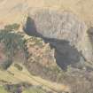
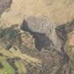
NS 9116 9769: This fort or dun has been greatly destroyed. The course of the wall, some 3 - 4m broad on the NW, can be traced all round the top of the spur on which the site lies. The interior is fairly level except for a slight rise on the S side, and is covered with stone debris. Where the inner face of the wall is visible, it can be seen that it was constructed with large undressed stones. About 10.0m beyond the N face of the wall is the ditch partly artificially cut through rock. At this point, on top of the scarp, is the faint course of a wall some 0.5m wide which is probably a remnant of the later sheepfold. An active quarry is encroaching on the SE of the site.
Visited by OS (J L D) 12 June 1953.
This fort has been totally destroyed by quarrying.
Visited by OS (J P) 11 December 1973.
Field Visit (17 March 1932)
Enclosure and Ditch, Castle Craig.
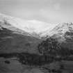
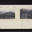
The Castle Craig, a rocky bluff of the Ochil Hills, rises abruptly to an elevation of 500 feet above sea-level on the right bank of a burn at the foot of the Mill Glen near Tillicoultry. On all sides, except at the north-west, it provides a situation of great natural strength. The Statistical Account (1795), vol. xv, p. 214, states: "On the Castle Craig, the foundations of a round circular building are still visible." A note to the passage reads: "Between these and the hills, there has been a ditch by way of defence. The vulgar tradition is, that the Peychts had a strong fortification in this place."
Unfortunately the constructions have been much destroyed and their precise character cannot now be settled. Local information is to the effect that some parts of a detached building, which formerly stood at the south-eastern edge of the cliff overlooking the burn, have been removed in recent years by quarrying operations. This information offers a possible explanation of the denuded remains that survive at a somewhat higher level. These consist of the lower courses of a strongly built semi-circular wall, which nowhere reaches a height of more than 4 feet above inside level and is flush with the natural ground-level on the outside. The wall is 12 feet thick at the central segment but becomes thinner towards the extremities. These at some later time have been linked together by a modern dike to form a D-shaped enclosure, which has its major axis north-north-east and south-south-west and measures roughly 95 feet by 65 feet. Within are traces of dividing walls and other later constructions. About 20 feet to the north-west of this strong wall is the ditch referred to in the Statistical Account. It is well defined, and in places has a depth and width of over 10 feet. Part of it has been cut through rock. The ditch is closely overlooked by higher ground, except towards the north, where a short stretch has its outer margin defined by an artificially constructed bank. No clear indications of an entrance passage could be observed, but the line of approach was probably from the west.
RCAHMS 1933, visited 17 March 1932.
Field Visit (16 June 1952)
This site was included within the RCAHMS Marginal Land Survey (1950-1962), an unpublished rescue project. Site descriptions, organised by county, are available to view online - see the searchable PDF in 'Digital Items'. These vary from short notes, to lengthy and full descriptions. Contemporary plane-table surveys and inked drawings, where available, can be viewed online in most cases - see 'Digital Images'. The original typecripts, notebooks and drawings can also be viewed in the RCAHMS search room.
Information from RCAHMS (GFG) 19 July 2013.
Note (1978)
Castle Craig, Tillicoultry NS 911 976 NS99NW 5
This promontory fort has been destroyed by quarrying. It comprised: (A) a circular enclosure measuring 25 m in diameter within a stone wall 3.7 m thick, with an entrance on the S; abutting onto the inner face of the wall there were the ruins of several apparently secondary stone-walled structures, in one of which a sherd of medieval pottery was found in an unstratified position; (B) some 12m outside the enclosure, a deep rock-cut ditch, accompanied by a stone wall on its inner lip and a stony rampart on its outer lip, cutting off access from the vulnerable NW quarter; a broad gap on the SW may originally have contained an entrance. In the absence of excavation the relationship of A to B was never established.
RCAHMS 1978
(Feachem 1955, 73-4; 1963, 114-15; DES, 1964, 57)
Note (8 September 2014 - 9 August 2016)
This small fortification occupied a low spur projecting from the SE flank of the hill on the W side of the mouth of the glen above Tillicoultry. Unfortunately it has been completely removed by Tillicoultry Quarry, but a plan drawn up by RCAHMS in 1952 shows that its defences comprised two elements: an inner stone walled enclosure; and an outer rampart with an external rock-cut ditch, which were drawn across the neck of the spur to isolate it from the rest of the hill. The inner enclosure was circular on plan, measuring 25m in diameter (0.05ha) within a wall 3.6m in thickness, and a gap in the wall on the SW possibly marked the position of the entrance. The inner face of the wall, still standing up to four courses high, was visible around the western half of the circuit, and a short section of the outer face on the NW. A watching brief was maintained during the demolition and a mechanical shovel was used to uncover a length of the outer face around the E side, revealing that it was built of massive blocks with small pinnings, which were also used to keep the lowest course roughly horizontal (Cruden 1964, 57). While the outer defences across the neck of the spur may have been no more than an outwork protecting the easiest line of approach to the inner enclosure, they might equally represent the remain of an earlier fort in its own right, effectively blocking access to a steep-sided promontory. The rampart had been reduced to a stony bank about 2m in thickness, but the ditch was an impressive feature up to 3.6m in depth, in places with vertical rock-cut sides at the bottom between 0.7m and 1.5m high; there were also remains of an external bank of upcast on the flanks of the spur. The area cut off measured 85m from NE to SW, by at least 85m transversely (0.5ha) at the time that the plan was drawn up, but by then the SE tip of the spur had already been removed. There may have been an entrance between the western end of these defences and the SW margin of the spur. Sherds of what is possibly coarse Roman pottery from 'Tillicoultry Craig' in the National Museum of Antiquities of Scotland (Robertson 1970, 225) possibly come from here, the only other 'Craig' placename nearby being Wester and Easter Kirk Craigs high up above the village on the opposite side of the glen
Information from An Atlas of Hillforts of Great Britain and Ireland – 09 August 2016. Atlas of Hillforts SC1858

