
Castle Campbell


Earthwork (Period Unassigned), Enclosure(S) (Period Unassigned)
Site Name Castle Campbell
Classification Earthwork (Period Unassigned), Enclosure(S) (Period Unassigned)
Canmore ID 48237
Site Number NS99NE 27
NGR NS 96103 99393
Datum OSGB36 - NGR
Permalink http://canmore.org.uk/site/48237


- Council Clackmannan
- Parish Dollar
- Former Region Central
- Former District Clackmannan
- Former County Clackmannanshire
Field Visit (17 April 2012 - 17 April 2012)
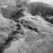
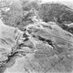
A topographical survey of the earthwork and surrounding area was undertaken by NTS staff. It is aligned E-W and measures 48.8m by 4.6m.
(Information from NTS, February 2013)
Excavation (9 April 2018 - 13 April 2018)
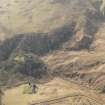
NS 96103 99393 Three trenches were excavated, 9–13 April
2018, at the location of a potential 17th-century siege works
on a hill platform on a slope opposite Castle Campbell in
Dollar Glen. Excavation uncovered one small fragment of
Green Glaze Red Earthenware and a metal detector survey
uncovered various modern picnic accoutrements.
Archive: NTS and NRHE (intended)
Funder: National Trust for Scotland
Daniel Rhodes – National Trust for Scotland
(Source DES, Volume 19)

