 |
On-line Digital Images |
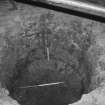
SC 1564164 |
Records of Scotia Archaeology Ltd, Aberfeldy, Perth and Kinross, Scotland |
Kinneil House Excavations
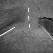
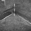
Frame 29 - Early stages of the removal of the infill of the well |
1/1993 |
Item Level |
|
 |
On-line Digital Images |
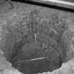
SC 1564165 |
Records of Scotia Archaeology Ltd, Aberfeldy, Perth and Kinross, Scotland |
Kinneil House Excavations
Frame 30 - Early stages of the removal of the infill of the well |
1/1993 |
Item Level |
|
 |
On-line Digital Images |
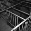
SC 1564166 |
Records of Scotia Archaeology Ltd, Aberfeldy, Perth and Kinross, Scotland |
Kinneil House Excavations
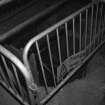
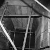
Frame 1 - Safety barriers at the top of the well
|
6/1994 |
Item Level |
|
 |
On-line Digital Images |
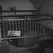
SC 1564167 |
Records of Scotia Archaeology Ltd, Aberfeldy, Perth and Kinross, Scotland |
Kinneil House Excavations
Frame 2 - Safety barriers at the top of the well
|
6/1994 |
Item Level |
|
 |
On-line Digital Images |
SC 1564168 |
Records of Scotia Archaeology Ltd, Aberfeldy, Perth and Kinross, Scotland |
Kinneil House Excavations
Frame 3 - Safety barriers at the top of the well
|
6/1994 |
Item Level |
|
 |
On-line Digital Images |
SC 1564169 |
Records of Scotia Archaeology Ltd, Aberfeldy, Perth and Kinross, Scotland |
Kinneil House Excavations
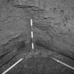
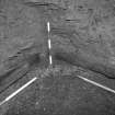
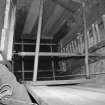
Frame 4 - Timbers in side of well shaft
|
6/1994 |
Item Level |
|
 |
On-line Digital Images |
SC 1564170 |
Records of Scotia Archaeology Ltd, Aberfeldy, Perth and Kinross, Scotland |
Kinneil House Excavations
Frame 5 - Timbers in side of well shaft |
6/1994 |
Item Level |
|
 |
On-line Digital Images |
SC 1564172 |
Records of Scotia Archaeology Ltd, Aberfeldy, Perth and Kinross, Scotland |
Kinneil House Excavations
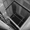
Frame 10 - View down the well shaft |
6/1994 |
Item Level |
|
 |
On-line Digital Images |
SC 1564173 |
Records of Scotia Archaeology Ltd, Aberfeldy, Perth and Kinross, Scotland |
Kinneil House Excavations
Frame 6 - Timbers in side of well shaft
|
6/1994 |
Item Level |
|
 |
On-line Digital Images |
SC 1564174 |
Records of Scotia Archaeology Ltd, Aberfeldy, Perth and Kinross, Scotland |
Kinneil House Excavations
Frame 7 - Timbers in side of well shaft
|
6/1994 |
Item Level |
|
 |
On-line Digital Images |
SC 1564175 |
Records of Scotia Archaeology Ltd, Aberfeldy, Perth and Kinross, Scotland |
Kinneil House Excavations
Frame 8 - View down the well shaft
|
6/1994 |
Item Level |
|
 |
On-line Digital Images |
SC 1564176 |
Records of Scotia Archaeology Ltd, Aberfeldy, Perth and Kinross, Scotland |
Kinneil House Excavations
Frame 9 - View down the well shaft
|
6/1994 |
Item Level |
|
 |
On-line Digital Images |
SC 1669504 |
RCAHMS Aerial Photography |
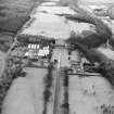
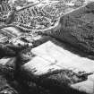
Aerial view of Kinneil House, Old Kinneil Kirk and the Antonine Wall (c. 9800 8052), taken from the NE. |
5/2/1997 |
Item Level |
|
 |
On-line Digital Images |
SC 1669693 |
RCAHMS Aerial Photography |
Aerial view. |
1976 |
Item Level |
|
 |
On-line Digital Images |
SC 1669694 |
RCAHMS Aerial Photography |
Aerial view. |
1976 |
Item Level |
|
 |
On-line Digital Images |
SC 1729304 |
|
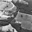
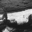
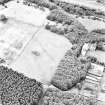
Kinneil, oblique aerial view, taken from the N, centred on the section of the Antonine Wall running adjacent to Old Kinneil Kirk. |
20/2/1996 |
Item Level |
|
 |
On-line Digital Images |
SC 1729305 |
|
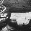
Kinneil, oblique aerial view, taken from the NNW, centred on the section of the Antonine Wall running adjacent to Old Kinneil Kirk. |
20/2/1996 |
Item Level |
|
 |
On-line Digital Images |
SC 1729306 |
|
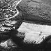
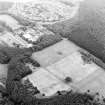
Kinneil, oblique aerial view, taken from the NNW, centred on the section of the Antonine Wall running adjacent to Old Kinneil Kirk. |
20/2/1996 |
Item Level |
|
 |
On-line Digital Images |
SC 1729307 |
|
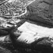
Kinneil, oblique aerial view, taken from the NW, centred on the section of the Antonine Wall running adjacent to Old Kinneil Kirk. |
20/2/1996 |
Item Level |
|
 |
On-line Digital Images |
SC 1729308 |
|
Kinneil, oblique aerial view, taken from the NW, centred on the section of the Antonine Wall running adjacent to Old Kinneil Kirk. |
20/2/1996 |
Item Level |
|
 |
On-line Digital Images |
SC 1729309 |
|
Kinneil, oblique aerial view, taken from the WNW, centred on the section of the Antonine Wall running adjacent to Old Kinneil Kirk. |
20/2/1996 |
Item Level |
|
 |
On-line Digital Images |
SC 1729320 |
|
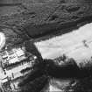
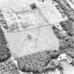
Oblique aerial view, taken from the SE, centred on a linear cropmark cutting across the route of the Antonine Wall. |
27/7/1996 |
Item Level |
|
 |
On-line Digital Images |
SC 1729321 |
|
Oblique aerial view, taken from the E, centred on a linear cropmark cutting across the route of the Antonine Wall. |
29/7/1996 |
Item Level |
|
 |
On-line Digital Images |
SC 1729326 |
RCAHMS Aerial Photography |
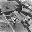
Oblique aerial view of Bo'ness, Kinneil, centred on the cropmarks of the Antonine Wall with a church and tower-house adjacent, taken from the NW. |
20/8/1997 |
Item Level |
|


