
Bo'ness, Church Wynd, Churchyards


Burial Ground (17th Century), Churchyard (17th Century)
Site Name Bo'ness, Church Wynd, Churchyards
Classification Burial Ground (17th Century), Churchyard (17th Century)
Alternative Name(s) Bo'ness Parish Churchyard
Canmore ID 48149
Site Number NS98SE 28
NGR NS 99710 81476
NGR Description NS 99689 81488 and NS 99726 81478
Datum OSGB36 - NGR
Permalink http://canmore.org.uk/site/48149


- Council Falkirk
- Parish Bo'ness And Carriden
- Former Region Central
- Former District Falkirk
- Former County West Lothian
NS98SE 28 99689 81488 and 99726 81478
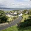
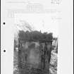
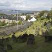
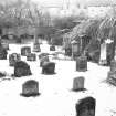
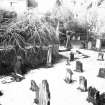
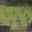
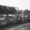
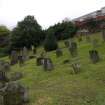
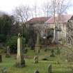
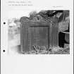
Stepped ashlar-coped rubble enclosing walls to E (Upper) and W (Lower) of Church Wynd. Many finely carved 17th and 18th century headstones, some re-used in 19th century, and mural monuments.
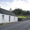
The graveyards flanking Church Wynd originally formed the burying ground of the former Bo'ness Old Kirk. The shore road often flooded at 'Corbie's Point', so Church Wynd was built during the 18th century at the Duke of Hamilton's request. The subsequent division of the burying ground led to the custom for people from Bo'ness to be buried in the Lower (W) ground and those from the Kinneil Estate in the Upper (E) ground. Owing to the parish church at Kinneil being some distance from the expanding seaport of Ness, a church was built at Corbiehall in 1634. The congregations were served by the minister from Kinneil until 1649 when Bo'ness was erected into a full charge. In 1669 an Act was passed declaring the church to be the 'Kirk of the Barony of Kinneil and Borrowstouness'. This Act suppressed the church of Kinneil and its parish and tiends were transferred to Bo'ness. The Duke of Hamilton added an aisle in 1672, the church was rebuilt in 1775 and again in 1820. Sold to the Episcopal Church in 1887, and subsequently to a private company, the building was converted to the Star Cinema by Matthew Steele in 1915, with the addition of an early Modern Movement façade. By 1964 the building was in use as a bingo hall, and was sold for conversion to a store and private dwelling during the 1990s. Category changed from B to A, 31 March 2004
Characterisation
This site falls within the Corbiehall and Snab Area of Townscape Character (NS98SE 207), which was defined as part of the RCAHMS Urban Survey Programme 2013. Text relating to the historical development and topography, and present character of the Corbiehall and Snab Area of Townscape Character can be viewed at site NS98SE 207.
Information from RCAHMS (LK), January 2014

